Category:Topographic maps of Ariège
Jump to navigation
Jump to search
Departments of Metropolitan France: Ain [01] · Aisne [02] · Allier [03] · Alpes-de-Haute-Provence [04] · Hautes-Alpes [05] · Alpes-Maritimes [06] · Ardèche [07] · Ardennes [08] · Ariège [09] · Aube [10] · Aude [11] · Aveyron [12] · Bouches-du-Rhône [13] · Calvados [14] · Cantal [15] · Charente [16] · Charente-Maritime [17] · Cher [18] · Corrèze [19] · Corse-du-Sud [2A]† · Haute-Corse [2B]† · Côte-d’Or [21] · Côtes-d'Armor [22] · Creuse [23] · Dordogne [24] · Doubs [25] · Drôme [26] · Eure [27] · Eure-et-Loir [28] · Finistère [29] · Gard [30] · Haute-Garonne [31] · Gers [32] · Gironde [33] · Hérault [34] · Ille-et-Vilaine [35] · Indre [36] · Indre-et-Loire [37] · Isère [38] · Jura [39] · Landes [40] · Loir-et-Cher [41] · Loire [42] · Haute-Loire [43] · Loire-Atlantique [44] · Loiret [45] · Lot [46] · Lot-et-Garonne [47] · Lozère [48] · Maine-et-Loire [49] · Manche [50] · Marne [51] · Haute-Marne [52] · Mayenne [53] · Meurthe-et-Moselle [54] · Meuse [55] · Morbihan [56] · Moselle [57] · Nièvre [58] · Nord [59] · Oise [60] · Orne [61] · Pas-de-Calais [62] · Puy-de-Dôme [63] · Pyrénées-Atlantiques [64] · Hautes-Pyrénées [65] · Pyrénées-Orientales [66] · Bas-Rhin [67] · Haut-Rhin [68] · departmental district of the Rhône [69] · Haute-Saône [70] · Saône-et-Loire [71] · Sarthe [72] · Savoie [73] · Haute-Savoie [74] · Paris [75] · Seine-Maritime [76] · Seine-et-Marne [77] · Yvelines [78] · Deux-Sèvres [79] · Somme [80] · Tarn [81] · Tarn-et-Garonne [82] · Var [83] · Vaucluse [84] · Vendée [85] · Vienne [86] · Haute-Vienne [87] · Vosges [88] · Yonne [89] · Territoire de Belfort [90] · Essonne [91] · Hauts-de-Seine [92] · Seine-Saint-Denis [93] · Val-de-Marne [94] · Val-d'Oise [95]
Overseas departments and regions: Guadeloupe [971] · Martinique [972] · French Guiana [973] · Réunion [974] · Mayotte [976]
Overseas collectivities: Saint Pierre and Miquelon [975] · Saint Barthélemy [977] · Saint-Martin [978] · Wallis and Futuna [986] · French Polynesia [987]
Sui generis territories: New Caledonia [988]
Subcategories
This category has the following 3 subcategories, out of 3 total.
O
S
- Soil shrink swell maps of Ariège (327 F)
Media in category "Topographic maps of Ariège"
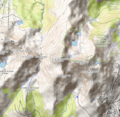
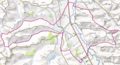
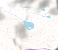
The following 114 files are in this category, out of 114 total.
-
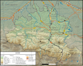
 759x599-Carte-09-Ariege-R.jpg 759 × 599; 181 KB
-
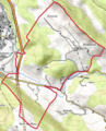
 Carte Ariege routes.svg 550 × 432; 3.63 MB
-
 Carte de l'Ariège.png 1,650 × 1,296; 3.02 MB
-
 Ariège department relief location map.jpg 1,054 × 858; 1.03 MB
-
 Aigues-Juntes OSM 02.png 1,276 × 864; 2.25 MB
-
 Aigues-Vives (Ariège) OSM 02.png 1,312 × 1,346; 2.82 MB
-
 Alos (Ariège) OSM 02.png 656 × 862; 1.35 MB
-
 Antras (Ariège) OSM 02.png 996 × 778; 1.82 MB
-
 Arabaux OSM 02.png 640 × 790; 1.1 MB
-
 Arac (rivière) OSM.png 1,384 × 756; 1.72 MB
-
 Argein OSM 02.png 900 × 1,468; 2.61 MB
-
 Arget (rivière) OSM.png 2,056 × 864; 3.24 MB
-
 Arnave (rivière).png 772 × 492; 510 KB
-
 Artigues (Ariège) OSM 02.png 718 × 886; 1.49 MB
-
 Artix (Ariège) OSM 02.png 663 × 435; 360 KB
-
 Aston (Ariège) OSM 02.png 774 × 1,044; 1.96 MB
-
 Aston (rivière) OSM.png 828 × 1,098; 1.65 MB
-
 Aucazein OSM 02.png 644 × 1,260; 1.79 MB
-
 Augirein OSM 02.png 916 × 1,136; 2.37 MB
-
 Axiat OSM 02.png 922 × 1,196; 2.52 MB
-
 Bagert OSM 02.png 882 × 724; 439 KB
-
 Balaguères OSM 02.png 1,466 × 1,356; 4.29 MB
-
 Barjac (Ariège) OSM 02.png 954 × 1,184; 1.26 MB
-
 Barrage du Sisca OSM.png 1,296 × 1,062; 1.87 MB
-
 Baulou OSM 02.png 965 × 770; 1.21 MB
-
 Betchat OSM 02.png 824 × 780; 1.35 MB
-
 Bethmale (Ariège) OSM 02.png 754 × 1,328; 2.35 MB
-
 Bompas (Ariège) OSM 02.png 686 × 600; 446 KB
-
 Bonnac (Ariège) OSM 02.png 849 × 400; 408 KB
-
 Bouan (Ariège) OSM 02.png 490 × 1,032; 1.17 MB
-
 Brassac (Ariège) OSM 02.png 898 × 822; 1.73 MB
-
 Brie (Ariège) OSM 02.png 966 × 968; 1.34 MB
-
 Buzan OSM 02.png 558 × 579; 534 KB
-
 Bédeille (Ariège) OSM 02.png 1,172 × 832; 1.89 MB
-
 Bélesta (Ariège) OSM 02.png 836 × 848; 1.24 MB
-
 Bénac (Ariège) OSM 02.png 974 × 672; 1.15 MB
-
 Bézac OSM 02.png 960 × 760; 1.53 MB
-
 Camarade (Ariège) OSM 02.png 858 × 772; 1.36 MB
-
 Camon (Ariège) OSM 02.png 1,058 × 1,128; 2.45 MB
-
 Cap de Bouirex OSM.png 519 × 469; 346 KB
-
 Castex (Ariège) OSM 02.png 529 × 415; 259 KB
-
 Caumont (Ariège) OSM 02.png 700 × 657; 602 KB
-
 Cazaux (Ariège) OSM 02.png 782 × 856; 1.16 MB
-
 Cazavet OSM 02.png 892 × 759; 1.04 MB
-
 Celles (Ariège) OSM 02.png 309 × 308; 239 KB
-
 Cescau (Ariège) OSM 02.png 585 × 452; 381 KB
-
 Château-Verdun (Ariège) OSM 02.png 540 × 756; 722 KB
-
 Clermont (Ariège) OSM 02.png 1,158 × 758; 1.52 MB
-
 Col de la Crouzette OSM.png 783 × 570; 546 KB
-
 Col de Port OSM.png 599 × 561; 347 KB
-
 Col de Portel OSM.png 807 × 654; 609 KB
-
 Col de Péguère OSM.png 736 × 572; 486 KB
-
 Cos (Ariège) OSM 02.png 752 × 942; 1.36 MB
-
 Dalou (Ariège) OSM 02.png 844 × 1,098; 1.69 MB
-
 Dourne.png 919 × 573; 806 KB
-
 Dun (Ariège) OSM 02.png 1,064 × 1,012; 2.54 MB
-
 Durfort (Ariège) OSM 02.png 1,076 × 1,158; 2.54 MB
-
 Engomer OSM 02.png 266 × 421; 208 KB
-
 Ercé (Ariège) OSM 02.png 684 × 585; 796 KB
-
 Erp OSM 02.png 623 × 581; 590 KB
-
 Eycheil OSM 02.png 453 × 574; 495 KB
-
 Fabas (Ariège) OSM 02.png 597 × 459; 526 KB
-
 Ferrières-sur-Ariège OSM 02.png 735 × 737; 431 KB
-
 Foix OSM 02.png 682 × 962; 1.3 MB
-
 Forêt de Bélesta (Ariège) OSM.png 1,972 × 1,318; 5.46 MB
-
 Fougax-et-Barrineuf OSM 02.png 670 × 433; 452 KB
-
 Gajan (Ariège) OSM 02.png 516 × 725; 484 KB
-
 Gestiès OSM 02.png 956 × 1,052; 2.39 MB
-
 Justiniac OSM 02.png 792 × 794; 1.26 MB
-
 La Bastide-de-Sérou OSM 02.png 790 × 494; 621 KB
-
 Labatut (Ariège) OSM 02.png 966 × 738; 891 KB
-
 Lacave (Ariège) OSM 02.png 1,716 × 1,274; 3.19 MB
-
 Lacourt OSM 02.png 736 × 758; 970 KB
-
 Lagarde (Ariège) OSM 02.png 1,450 × 970; 2.62 MB
-
 Lanoux OSM 02.png 1,618 × 888; 2.06 MB
-
 Lapenne OSM 02.png 1,858 × 1,228; 3.62 MB
-
 Larnat OSM 02.png 297 × 419; 155 KB
-
 Lasserre (Ariège) OSM 02.png 347 × 395; 154 KB
-
 Lassur OSM 02.png 270 × 499; 242 KB
-
 Le Bosc (Ariège) OSM 02.png 732 × 842; 1.37 MB
-
 Lercoul OSM 02.png 866 × 1,074; 2.21 MB
-
 Les Cabannes (Ariège) OSM 02.png 798 × 838; 1.33 MB
-
 Lescure (Ariège) OSM 02.png 816 × 1,092; 1.79 MB
-
 Lesparrou OSM 02.png 1,948 × 1,058; 3.33 MB
-
 Lez (affluent du Salat) OSM.png 1,230 × 1,192; 2.71 MB
-
 Lissac (Ariège) OSM 02.png 1,064 × 868; 1.37 MB
-
 Lordat OSM 02.png 1,690 × 1,334; 4.12 MB
-
 Lorp-Sentaraille OSM 02.png 816 × 926; 1.3 MB
-
 Loubaut OSM 02.png 1,262 × 886; 1.14 MB
-
 Loubens (Ariège) OSM 02.png 791 × 616; 951 KB
-
 Loubières OSM 02.png 1,222 × 984; 1.76 MB
-
 Léran OSM 02.png 1,364 × 1,224; 2.93 MB
-
 Massif de Tabe OSM.png 1,520 × 1,222; 4.47 MB
-
 Mont Fourcat OSM.png 1,018 × 990; 2.26 MB
-
 Montoulieu (Ariège) OSM 02.png 985 × 689; 717 KB
-
 Orgibet OSM 02.png 237 × 505; 144 KB
-
 Orle (rivière) OSM.png 534 × 1,264; 1.47 MB
-
 Pic de Saint-Barthélemy OSM.png 1,018 × 990; 2.38 MB
-
 Quiol OSM.png 750 × 1,030; 1.73 MB
-
 Quié de Lujat OSM.png 1,060 × 830; 1.63 MB
-
 Ruisseau d'Artiès OSM.png 662 × 1,288; 1.65 MB
-
 Ruisseau d'Escalès OSM.png 550 × 1,066; 1.13 MB
-
 Ruisseau de Carol OSM.png 1,794 × 1,266; 3.36 MB
-
 Ruisseau de Dalou OSM.png 608 × 674; 568 KB
-
 Ruisseau de Liers OSM.png 1,169 × 727; 1.29 MB
-
 Ruisseau de Senesse OSM.png 1,044 × 1,024; 1.79 MB
-
 Ruisseau de Siguer OSM.png 550 × 1,006; 1.02 MB
-
 Sainte-Suzanne (Ariège) OSM 02.png 1,662 × 902; 2.74 MB
-
 Tarascon-sur-Ariège OSM 02.png 861 × 669; 633 KB
-
 Troye-d'Ariège OSM 02.png 998 × 1,242; 2.16 MB
-
 Étang d'Appy OSM.png 1,018 × 990; 2 MB
-
 Étang de Réglisse OSM.png 779 × 674; 329 KB
-
 Étang des Truites OSM.png 644 × 602; 320 KB
-
 Étang du Diable OSM.png 796 × 696; 527 KB


_OSM_02.png)
_OSM_02.png)
_OSM_02.png)

_OSM.png)

_OSM.png)
.png)
_OSM_02.png)
_OSM_02.png)
_OSM_02.png)
_OSM.png)


_OSM_02.png)


_OSM_02.png)
_OSM_02.png)
_OSM_02.png)
_OSM_02.png)
_OSM_02.png)
_OSM_02.png)

_OSM_02.png)
_OSM_02.png)
_OSM_02.png)

_OSM_02.png)
_OSM_02.png)

_OSM_02.png)
_OSM_02.png)
_OSM_02.png)

_OSM_02.png)
_OSM_02.png)
_OSM_02.png)
_OSM_02.png)


_OSM_02.png)
_OSM_02.png)

_OSM_02.png)
_OSM_02.png)

_OSM_02.png)


_OSM_02.png)


_OSM.png)

_OSM_02.png)


_OSM_02.png)
_OSM_02.png)

_OSM_02.png)


_OSM_02.png)

_OSM_02.png)

_OSM_02.png)
_OSM_02.png)

_OSM.png)
_OSM_02.png)


_OSM_02.png)


_OSM_02.png)

_OSM.png)


_OSM_02.png)


