Category:Tickencote
Jump to navigation
Jump to search
village in Rutland, England, UK  | |||||
| Upload media | |||||
| Instance of | |||||
|---|---|---|---|---|---|
| Location | Rutland, East Midlands, England | ||||
| Area |
| ||||
| official website | |||||
 | |||||
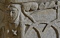
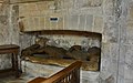
English: Tickencote is a small village in the county of Rutland in the East Midlands of England. It is famous for its church of St. Peter, which possesses a superb Norman chancel arch and unusual chancel roof ribbing.
Subcategories
This category has only the following subcategory.
Media in category "Tickencote"
The following 141 files are in this category, out of 141 total.
-
 A bit of welcome shade west of Tickencote - geograph.org.uk - 3085007.jpg 1,024 × 768; 188 KB
-
 A1 - on the Roman road - geograph.org.uk - 2643743.jpg 640 × 428; 91 KB
-
 A1 - turning for Woolfox Depot - geograph.org.uk - 2643760.jpg 640 × 428; 76 KB
-
 A1 - turning for Woolfox Depot ahead - geograph.org.uk - 2643752.jpg 640 × 428; 72 KB
-
 A1 along Ermine Street - geograph.org.uk - 3456569.jpg 1,590 × 961; 918 KB
-
 A1 approaching Empingham and Pickworth turn off - geograph.org.uk - 3553243.jpg 1,983 × 1,170; 1.27 MB
-
 A1 Great North Road - geograph.org.uk - 4217295.jpg 640 × 480; 300 KB
-
 A1 Great North Road - geograph.org.uk - 4217298.jpg 640 × 480; 250 KB
-
 A1 junction at Bloody Oaks - geograph.org.uk - 3996424.jpg 1,600 × 1,219; 574 KB
-
 A1 near Tickencote - geograph.org.uk - 3184751.jpg 640 × 430; 38 KB
-
 A1 northbound, rain ahead - geograph.org.uk - 3456559.jpg 1,584 × 958; 904 KB
-
 A1 slip road for Empingham and Woolfox Depot - geograph.org.uk - 3553528.jpg 1,920 × 1,122; 1.08 MB
-
 A1 Southbound, junction for Stamford B1081 - geograph.org.uk - 3456510.jpg 1,779 × 1,024; 792 KB
-
 B1081 northbound - geograph.org.uk - 6249762.jpg 640 × 480; 80 KB
-

-
 Bloody Oaks Quarry - geograph.org.uk - 166460.jpg 640 × 480; 96 KB
-
 Bloody Oaks Quarry - geograph.org.uk - 3996629.jpg 1,600 × 1,209; 654 KB
-
 Church of St Peter, Tickencote - geograph.org.uk - 5968305.jpg 3,776 × 2,520; 3.98 MB
-
 Close up of the Information board at Bloody Oaks Quarry - geograph.org.uk - 3996556.jpg 1,600 × 1,073; 445 KB
-
 Cyclist on national cycle route 63 - geograph.org.uk - 3085024.jpg 1,024 × 768; 149 KB
-
 Diner at Bloody Oaks services - geograph.org.uk - 3264254.jpg 1,024 × 768; 115 KB
-
 Driveway to Tickencote Warren - geograph.org.uk - 3996382.jpg 1,600 × 1,179; 808 KB
-
 East Wood from the road - geograph.org.uk - 350838.jpg 640 × 480; 119 KB
-
 Empingham Lane leaving Tickencote - geograph.org.uk - 5968248.jpg 3,776 × 2,520; 4.16 MB
-
 Empingham Lane passing the entrance to Tickencote Lodge Farm - geograph.org.uk - 5968237.jpg 3,776 × 2,520; 4.09 MB
-
 Empingham Road - geograph.org.uk - 6249768.jpg 640 × 480; 83 KB
-
 Empingham Road - geograph.org.uk - 6249772.jpg 640 × 480; 79 KB
-
 Empingham Road - geograph.org.uk - 6249779.jpg 640 × 480; 57 KB
-
 Empingham turning, A1 - geograph.org.uk - 3184754.jpg 640 × 430; 40 KB
-

-
 Entrance to Tickencote Warren - geograph.org.uk - 3350282.jpg 640 × 375; 56 KB
-
 Farmland north of Tickencote - geograph.org.uk - 5968282.jpg 3,776 × 2,520; 4.23 MB
-
 Field by Tickencote Laund - geograph.org.uk - 3350301.jpg 640 × 467; 42 KB
-
 Gates leading into Wing Plantations - geograph.org.uk - 3996661.jpg 1,600 × 1,200; 607 KB
-
 Information board at Bloody Oaks Quarry - geograph.org.uk - 3996551.jpg 1,600 × 1,200; 694 KB
-
 Layby on the A1 near Tickencote - geograph.org.uk - 4217297.jpg 640 × 427; 258 KB
-
 Looking south down the Great North Road - geograph.org.uk - 5443346.jpg 3,776 × 2,520; 4.21 MB
-
 Lorry in the sky - geograph.org.uk - 2131294.jpg 1,024 × 768; 137 KB
-
 Northbound A1 (Great North Road) - geograph.org.uk - 4217300.jpg 640 × 480; 272 KB
-
 Northbound A1, Exit at Bloody Oaks - geograph.org.uk - 4217305.jpg 640 × 480; 250 KB
-
 Northbound A1, Tickencote - geograph.org.uk - 4217292.jpg 640 × 480; 257 KB
-
 Northbound A1, Tickencote Services - geograph.org.uk - 4217293.jpg 640 × 480; 262 KB
-
 Oat field bounded by Tickencote Laund - geograph.org.uk - 3085014.jpg 1,024 × 768; 133 KB
-
 Oat field on a sunny day - geograph.org.uk - 3085018.jpg 1,024 × 768; 215 KB
-
 Services by the A1 at Tickencote - geograph.org.uk - 2621913.jpg 640 × 430; 49 KB
-
 Signpost by the A1 overbridge - geograph.org.uk - 2131299.jpg 1,024 × 768; 204 KB
-
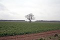 Solitary tree in a field - geograph.org.uk - 138082.jpg 640 × 427; 61 KB
-
 Somewhere under here is a Roman road - geograph.org.uk - 2131306.jpg 1,024 × 768; 190 KB
-
 South-bound slip road - geograph.org.uk - 2131311.jpg 1,024 × 768; 166 KB
-

-

-
 St Peter ^ St Paul, Tickencote - Corbel - geograph.org.uk - 4470536.jpg 622 × 900; 214 KB
-
 St Peter ^ St Paul, Tickencote - Corbel - geograph.org.uk - 4470537.jpg 706 × 900; 271 KB
-
 St Peter ^ St Paul, Tickencote - Corbel - geograph.org.uk - 4470541.jpg 684 × 900; 270 KB
-
 St Peter ^ St Paul, Tickencote - Corbel - geograph.org.uk - 4470542.jpg 734 × 900; 242 KB
-

-

-

-
 St Peter ^ St Paul, Tickencote - geograph.org.uk - 4470512.jpg 900 × 657; 258 KB
-
 St Peter ^ St Paul, Tickencote - geograph.org.uk - 4470513.jpg 900 × 558; 211 KB
-
 St Peter ^ St Paul, Tickencote - geograph.org.uk - 4470515.jpg 900 × 599; 202 KB
-
 St Peter ^ St Paul, Tickencote - geograph.org.uk - 4470516.jpg 640 × 458; 86 KB
-
 St Peter ^ St Paul, Tickencote - geograph.org.uk - 4470518.jpg 900 × 628; 361 KB
-

-

-

-

-
 St Peter's church, Tickencote - geograph.org.uk - 2959974.jpg 1,600 × 1,067; 277 KB
-
 The A1 northbound at the Tickencote services - geograph.org.uk - 4070131.jpg 2,000 × 1,500; 1.04 MB
-
 The A1 northbound near Tickencote - geograph.org.uk - 5968346.jpg 3,776 × 2,520; 3.95 MB
-
 The churchyard, Tickencote - geograph.org.uk - 3365946.jpg 1,024 × 768; 208 KB
-
 The drive to Tickencote Warren - geograph.org.uk - 2131302.jpg 1,024 × 768; 227 KB
-
 The road to Cross Roads Farm - geograph.org.uk - 3084995.jpg 1,024 × 768; 168 KB
-
 The road to the A1 - geograph.org.uk - 3090279.jpg 1,024 × 768; 184 KB
-
 The road to Tickencote and Great Casterton - geograph.org.uk - 3084990.jpg 1,024 × 768; 190 KB
-
 The southbound A1, approaching Stamford - geograph.org.uk - 3748877.jpg 2,592 × 1,944; 1.84 MB
-
 The Tickencote trunk road services - geograph.org.uk - 4070143.jpg 2,000 × 1,475; 993 KB
-
 Tickencote St Peter's Church - geograph.org.uk - 4280598.jpg 3,660 × 2,286; 4.53 MB
-
 Tickencote St Peter's Church - geograph.org.uk - 4280603.jpg 3,106 × 2,984; 4.35 MB
-
 Tickencote St Peter's Church - geograph.org.uk - 4280661.jpg 2,842 × 3,646; 5.61 MB
-
 Tickencote St Peter's Church - geograph.org.uk - 4280664.jpg 2,857 × 3,655; 2.83 MB
-
 Tickencote, chancel arch details - geograph.org.uk - 1884785.jpg 800 × 600; 178 KB
-
 Tickencote, Church Lane - geograph.org.uk - 5906815.jpg 4,592 × 3,448; 5.55 MB
-
 Tickencote, St Peter - chancel ceiling - geograph.org.uk - 4466951.jpg 1,024 × 1,024; 1.41 MB
-
 Tickencote, St Peter's Church - geograph.org.uk - 4396304.jpg 4,168 × 2,586; 6.77 MB
-
 Tickencote, St Peter's Church - geograph.org.uk - 4396312.jpg 5,419 × 3,188; 7.72 MB
-
 Tickencote, St Peter's Church - geograph.org.uk - 4396319.jpg 3,277 × 2,185; 3.48 MB
-
 Tickencote, St. Peter's Church - geograph.org.uk - 4504790.jpg 3,627 × 2,373; 4.6 MB
-
 Tickencote, St. Peter's Church - geograph.org.uk - 4504797.jpg 3,670 × 2,432; 5.09 MB
-
 Tickencote, St. Peter's Church - geograph.org.uk - 4504805.jpg 3,678 × 2,456; 4.89 MB
-
 Tickencote, St. Peter's Church - geograph.org.uk - 4504816.jpg 3,620 × 2,365; 4.74 MB
-
 Tickencote, St. Peter's Church - geograph.org.uk - 4504819.jpg 3,592 × 2,316; 4.2 MB
-
 Tickencote, St. Peter's Church and Lych Gate - geograph.org.uk - 4504812.jpg 3,678 × 2,456; 4.79 MB
-

-

-

-

-
-

-

-

-

-

-

-

-

-
 Tickencote, St. Peter's Church, Stained glass window - geograph.org.uk - 4504890.jpg 2,235 × 3,243; 4.75 MB
-

-

-

-

-
-

-
 Tickencote, St. Peter's Church, The nave from the chancel - geograph.org.uk - 4505224.jpg 4,593 × 3,018; 6.66 MB
-

-

-

-

-

-
 Towards Exton - geograph.org.uk - 3350302.jpg 640 × 480; 52 KB
-
 Towards the south - geograph.org.uk - 3350285.jpg 640 × 444; 55 KB
-
 Towards Wing Plantations - geograph.org.uk - 3350281.jpg 640 × 467; 48 KB
-
 Towards Woolfox Depot - geograph.org.uk - 3350286.jpg 640 × 520; 62 KB
-
 Track towards Tickencote Lodge Farm - geograph.org.uk - 3350279.jpg 640 × 466; 50 KB
-
 Turn off the A1 near Bloody Oaks - geograph.org.uk - 2511211.jpg 640 × 332; 33 KB
-
 Wild's Lodge in the Gwash valley - geograph.org.uk - 3973737.jpg 1,600 × 1,102; 505 KB
-

-
 Bridleway across the fields to Ingthorpe - geograph.org.uk - 350861.jpg 640 × 480; 133 KB
-
 Bridleway from Mounts Lodge - geograph.org.uk - 350850.jpg 640 × 480; 142 KB
-

-
 Field - geograph.org.uk - 379118.jpg 640 × 480; 102 KB
-
 Field and Stream - geograph.org.uk - 379122.jpg 640 × 480; 112 KB
-
 Footpath and bridleway junction - geograph.org.uk - 488160.jpg 640 × 477; 110 KB
-
 Grazing land above Empingham - geograph.org.uk - 488172.jpg 640 × 477; 70 KB
-

-
 Lose Coat Field - geograph.org.uk - 116176.jpg 640 × 427; 95 KB
-

-
 Rutland Round circular walk - geograph.org.uk - 350852.jpg 640 × 480; 130 KB
-
 Stile and footpath near Tickencote - geograph.org.uk - 138085.jpg 640 × 427; 77 KB
-
 Tickencote Park - geograph.org.uk - 138086.jpg 640 × 427; 40 KB
-
 Towards A1 Gt North Road - geograph.org.uk - 166463.jpg 640 × 480; 83 KB


_-_geograph.org.uk_-_4217300.jpg)


