Category:Tiansiang
Jump to navigation
Jump to search
a village in Hualien County  | |||||
| Upload media | |||||
| Instance of |
| ||||
|---|---|---|---|---|---|
| Named after |
| ||||
| Location | Fushi Village, Xiulin, Hualien County, Taiwan Province, ROC | ||||
 | |||||
English: Tianhsiang(or Tianxiang)is one of the landmarks within the Taroko National Park. It is a river terrace, which occupies the area in between Central Cross-Island Highway in Xiulin Town and east side of the spectacular Taroko Gorge at juncture area of Dasha River, Liwu River, and Daxi Jili River.Scenic spots at Tianxiang include Hsiang-Te Temple, Tianfeng Pagoda, a suspension bridge, the Wen Tianxiang Memorial Garden, the Plum Garden, and Tiansiang Church.
日本語: 天祥は太魯閣峡谷の見所の終点です。ここの地名は宋代末の忠臣、文天祥にちなんだもので、彼の石像もあります。また吊り橋で沢を越えると向かいの山腹に七重の塔、天峰塔と祥德寺か立つています。
中文:天祥,舊名塔比多、塔比督、得比督,戰後初期則譯作大北投,海拔485公尺,台灣旅遊景點,位於台8線169.7公里處,是太魯閣國家公園景點之一,行政區域轄屬花蓮縣秀林鄉富世村。
中文(繁體):天祥,舊名塔比多、塔比督、得比督,戰後初期則譯作大北投,海拔485公尺,台灣旅遊景點,位於台8線169.7公里處,是太魯閣國家公園景點之一,行政區域轄屬花蓮縣秀林鄉富世村。
中文(臺灣):天祥,舊名塔比多、塔比督、得比督,戰後初期則譯作大北投,海拔485公尺,台灣旅遊景點,位於台8線169.7公里處,是太魯閣國家公園景點之一,行政區域轄屬花蓮縣秀林鄉富世村。
Subcategories
This category has the following 10 subcategories, out of 10 total.
H
P
S
- Sakuma Shrine (5 F)
- Silks Place Taroko Hotel (13 F)
T
- Tianxiang Police Station (1 F)
- Tianxiang Terrace (12 F)
W
- Wen Tianxiang Park (5 F)
Z
- Zhihui Bridge (31 F)
Media in category "Tiansiang"
The following 19 files are in this category, out of 19 total.
-
 2010-02-16 Dinnertime in Taroko National Park.jpg 2,112 × 2,816; 1.46 MB
-
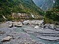
 A rocky valley in Tiansiang Taroko.jpg 1,920 × 1,080; 852 KB
-
 Central Cross-lsland Highway Museum.jpg 4,032 × 3,024; 3.37 MB
-
 Hotel Grand Formosa, Tianxiang 天祥晶華酒店 - panoramio.jpg 2,444 × 1,712; 2.25 MB
-
 Information board in Tienhsiang Youth Activity Center.jpg 1,920 × 1,080; 788 KB
-
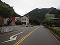
 Road in Tiansiang 01.jpg 1,920 × 1,080; 913 KB
-
 Road in Tiansiang.jpg 1,920 × 1,080; 865 KB
-
 Taiwan Taroko-Schlucht 125.jpg 4,576 × 3,428; 6.53 MB
-
 Taiwan Taroko-Schlucht 126.jpg 4,550 × 3,392; 7.21 MB
-
 Tiansiang approach.jpg 2,848 × 2,136; 1.5 MB
-
 Tianxiang at noon on 21 October 2017.jpg 3,840 × 2,160; 2.12 MB
-
 Tien-Shiang Hotel in Hualien 198806.jpg 1,937 × 1,012; 1.77 MB
-
 Tien-Shiang Hotel in Hualien.jpg 2,051 × 1,376; 2.47 MB
-
 Tienhsiang in Taroko National Park (5450771577).jpg 2,000 × 3,008; 2.94 MB
-
 Tienhsiang in Taroko National Park (5450775639).jpg 2,000 × 3,008; 2.96 MB
-
 View at Tienhsiang Youth Activity Center.jpg 1,920 × 1,080; 837 KB
-
 天祥 Tianxiang - panoramio.jpg 1,846 × 1,384; 901 KB
-
 天祥梅園 Tianxiang Plum Garden - panoramio.jpg 4,402 × 3,302; 3.75 MB
-
 天祥管理站 - Tianxiang Service Station - 2012.02 - panoramio.jpg 3,200 × 2,400; 3.05 MB


.jpg)
.jpg)


