Category:Thornton Hough Village Smithy
Jump to navigation
Jump to search
| Object location | | View all coordinates using: OpenStreetMap |
|---|
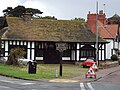
Grade II listed smithy in Wirral, England  | |||||
| Upload media | |||||
| Instance of | |||||
|---|---|---|---|---|---|
| Location | Wirral, Merseyside, North West England, England | ||||
| Heritage designation |
| ||||
 | |||||
Media in category "Thornton Hough Village Smithy"
The following 4 files are in this category, out of 4 total.
-
 Benkid77 Thornton Hough Smithy 240709.JPG 3,648 × 2,736; 3.52 MB
-
 The Smithy.jpg 3,008 × 2,000; 1.55 MB
-
 Thornton Hough Village Smithy sign.jpg 3,349 × 4,897; 18.57 MB
-
 Thornton Hough Village Smithy.jpg 4,802 × 2,895; 14.8 MB


