Category:The Grey Mare and her colts
Jump to navigation
Jump to search
This is a category about listed building number 1002671. |
| Object location | | View all coordinates using: OpenStreetMap |
|---|
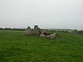
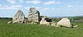
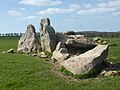
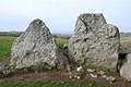
dolmen in England  | |||||
| Upload media | |||||
| Instance of |
| ||||
|---|---|---|---|---|---|
| Location | Long Bredy, Dorset, South West England, England | ||||
| Heritage designation | |||||
 | |||||
Media in category "The Grey Mare and her colts"
The following 12 files are in this category, out of 12 total.
-
-
 Grey Mare & Her Colts - 46756737014.jpg 4,833 × 2,176; 2.33 MB
-
 Grey Mare & Her Colts.jpg 4,896 × 3,672; 6.12 MB
-
 Grey Mare and her Colts - geograph.org.uk - 180692.jpg 640 × 426; 80 KB
-
 Grey Mare and her Colts - geograph.org.uk - 995.jpg 640 × 480; 148 KB
-
 Grey Mare and Her Colts 2.jpg 2,368 × 1,371; 747 KB
-
 Grey Mare and her Colts 3.jpg 2,592 × 1,552; 764 KB
-
 Grey Mare and her Colts.jpg 2,592 × 1,552; 1.54 MB
-
 The Grey Mare and Her Colts - geograph.org.uk - 4172664.jpg 1,737 × 1,158; 700 KB
-
 The Grey Mare and her Colts - geograph.org.uk - 5118961.jpg 640 × 480; 63 KB
-
-


