Category:Thames Down Link
Jump to navigation
Jump to search
| Upload media | |||||
| Instance of | |||||
|---|---|---|---|---|---|
| Location |
| ||||
| Length |
| ||||
| Terminus | |||||
 | |||||
The Thames Down Link is an official walking route linking the Thames Path and the North Downs Way.
Media in category "Thames Down Link"
The following 19 files are in this category, out of 19 total.
-
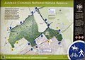 Ashtead Common Nature Reserve Information board.jpg 2,500 × 1,771; 1,014 KB
-
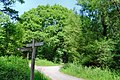 Ashtead Common, Thames Downs Link path.jpg 3,000 × 2,001; 2.4 MB
-
 Ashtead Park Nature Reserve information board.jpg 2,000 × 1,412; 840 KB
-
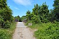
 Castle Hill Nature Reserve, Chessington.jpg 2,000 × 1,524; 979 KB
-
 Epsom Common, Thames Downs Link path.jpg 2,500 × 1,666; 2.02 MB
-
 Hobbledown Children's Farm, Bactrian Camels.jpg 2,000 × 1,337; 401 KB
-
 Hobbledown Children's Farm, Nilgai.jpg 2,000 × 1,280; 527 KB
-
 Hogsmill River Park.jpg 3,000 × 2,250; 3.56 MB
-
 Hogsmill river, Tolworth.jpg 2,500 × 1,662; 1.73 MB
-
 Hogsmill, Loop, TDL sign.jpg 1,200 × 322; 136 KB
-
 Horton Country Park car park.jpg 2,000 × 1,423; 845 KB
-
 Kingston, Clattern Bridge, Hogsmill river.jpg 2,250 × 3,000; 1.14 MB
-
 Stane Street crossing the M25.jpg 2,500 × 1,662; 1.47 MB
-
 Stane Street, Tyrrell's Wood.jpg 3,000 × 1,995; 3.11 MB
-
 Thames Down Link sign.jpg 905 × 943; 228 KB
-
 Thames Downs Link, Ashtead.jpg 3,000 × 1,995; 3.34 MB
-
 Thames Downs Link, Tolworth.jpg 2,001 × 3,000; 1.26 MB
-
 Upper Pond, Ashtead Park.jpg 3,000 × 1,995; 2.08 MB
-
 West Park Water Tower from Horton Country Park.jpg 3,000 × 1,995; 1.23 MB


