Category:Tallebudgera Creek
river in Queensland, Australia  | |||||
| Upload media | |||||
| Instance of | |||||
|---|---|---|---|---|---|
| Location | Queensland, AUS | ||||
| Mouth of the watercourse | |||||
 | |||||
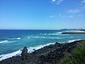
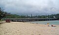
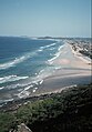
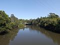
The Tallebudgera Creek is a creek located in South East Queensland, Australia. Its catchment lies within the Gold Coast local government area and covers an area of 98 square kilometres (38 sq mi). The river is approximately 25 kilometres (16 mi) in length and is known for good fishing.
The Tallebudgera Creek rises from the Springbrook Plateau below Burleigh Mountain in the Springbrook National Park near Upper Tallebudgera and north of the New South Wales/Queensland border. The creek flows generally north by east through the Tallebudgera Valley towards Burleigh Heads where it is crossed by the Pacific Motorway and the Gold Coast Highway, before reaching its mouth south of the Burleigh Head National Park and emptying into the Coral Sea. The creek descends 100 metres (330 ft) over its 25-kilometre (16 mi) course. The name Tallebudgera comes from the Yugambeh word "Jalubay-ngagam", which means "dingo's urine".
Media in category "Tallebudgera Creek"
The following 26 files are in this category, out of 26 total.
-
 A Rescue Boat Exits Tallebudgera Creek - panoramio.jpg 3,264 × 2,448; 3.17 MB
-
 Burleigh Heads and Tallebudgera Creek 2.JPG 2,048 × 1,536; 1.8 MB
-
 Burleigh Heads and Tallebudgera Creek.JPG 2,048 × 1,536; 1.82 MB
-
 Cannon Rock and Tallebudgera Creek Mouth - panoramio.jpg 3,264 × 2,448; 3.01 MB
-
 GC Burleigh Head NP from palm beach.jpg 1,600 × 1,200; 634 KB
-
 GC Burleigh Heads entrance sign.jpg 1,600 × 1,200; 902 KB
-
 GC Burleigh Heads tallebudgera creek foreshore.jpg 1,600 × 1,200; 620 KB
-
 Gold Coast Highway over Tallebudgera Creek.JPG 2,003 × 1,204; 1.55 MB
-
 My Sea Eagle 330 at Tallebudgera Creek (2099452582).jpg 800 × 600; 116 KB
-

-

-
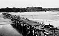 StateLibQld 1 109100 Tallebudgera Creek Bridge, Burleigh Heads, 1926.jpg 1,000 × 617; 78 KB
-
 Tallebudgera Creek (before beach groyne), Gold Coast, ca.early 1970s QUT-425.jpg 2,404 × 3,460; 3.02 MB
-
 Tallebudgera Creek and beach groyne, Gold Coast, early 1980s QUT-428.jpg 5,243 × 3,502; 2.72 MB
-
 Tallebudgera Creek at Coplicks Lane 2, Tallebudgera, Queensland.jpg 3,264 × 2,448; 4.69 MB
-
 Tallebudgera Creek at Coplicks Lane 3, Tallebudgera, Queensland.jpg 3,264 × 2,448; 4.65 MB
-
 Tallebudgera Creek at Coplicks Lane, Tallebudgera, Queensland.jpg 3,264 × 2,448; 3.91 MB
-
 Tallebudgera Creek Gold Coast 1980s IMG 0071.jpg 6,339 × 4,293; 22.24 MB
-
 Tallebudgera Creek Gold Coast 1980s IMG 0078.jpg 6,441 × 4,306; 21 MB
-
 Tallebudgera Creek looking W from GC Hwy 1.jpg 1,600 × 1,200; 555 KB
-
 Tallebudgera Creek looking W from GC Hwy 2.jpg 1,600 × 1,200; 585 KB
-
 Tallebudgera Creek Mouth - panoramio (1).jpg 2,448 × 3,264; 3.12 MB
-
 Tallebudgera Creek Mouth - panoramio.jpg 3,264 × 2,448; 3.11 MB
-
 Tallebudgera creek, qld.jpg 2,048 × 1,151; 1.61 MB
-
 Tallebudgera creek.jpeg 3,264 × 2,040; 1.72 MB
-
 View Up Tallebudgera Creek to Hinterland - panoramio.jpg 3,264 × 1,744; 1.46 MB


.jpg)


,_Gold_Coast,_ca.early_1970s_QUT-425.jpg)


.jpg)


