Category:Taganana
Jump to navigation
Jump to search
| Camera location | | View all coordinates using: OpenStreetMap |
|---|
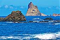
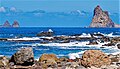
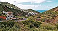
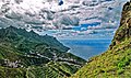
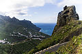
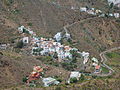
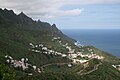
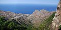
English: Pictures of Taganana, a village belongs to the municipality of Santa Cruz de Tenerife, in the northeastern part of the island of Tenerife one of the islands of the Canary Islands in Spain. Taganana is near the Anaga Massif and the mountain range Macizo de Anaga. Taganana is near the road TF-134
 | |||||
| Upload media | |||||
| Instance of | |||||
|---|---|---|---|---|---|
| Location | Santa Cruz de Tenerife, Santa Cruz de Tenerife Province, Canary Islands, Spain | ||||
 | |||||
Subcategories
This category has the following 3 subcategories, out of 3 total.
- Maps of Taganana (1 F)
R
- Roque de las Bodegas (12 F)
Media in category "Taganana"
The following 51 files are in this category, out of 51 total.
-
 'Taganana - Tenerife' by Orestes Anatolio, Hotel Nacional de Cuba.JPG 3,244 × 2,112; 970 KB
-
 -ERMITA DE LA CARIDAD DEL COBRE-TENERIFE, ISLAS CANARIAS - panoramio.jpg 1,200 × 1,600; 318 KB
-
 700 Menschen leben im größten Ort des Anaga Gebirges. 01.jpg 1,319 × 758; 557 KB
-
 700 Menschen leben im größten Ort des Anaga Gebirges. 02.jpg 1,235 × 810; 625 KB
-
 700 Menschen leben im größten Ort des Anaga Gebirges. 03.jpg 858 × 1,165; 657 KB
-
 700 Menschen leben im größten Ort des Anaga Gebirges. 04.jpg 834 × 1,199; 497 KB
-
 700 Menschen leben im größten Ort des Anaga Gebirges. 05.jpg 816 × 1,225; 502 KB
-
 700 Menschen leben im größten Ort des Anaga Gebirges. 06.jpg 1,225 × 816; 460 KB
-
 700 Menschen leben im größten Ort des Anaga Gebirges. 07.jpg 1,225 × 816; 430 KB
-
 700 Menschen leben im größten Ort des Anaga Gebirges. 08.jpg 1,318 × 759; 491 KB
-
 700 Menschen leben im größten Ort des Anaga Gebirges. 09.jpg 853 × 1,172; 486 KB
-
 700 Menschen leben im größten Ort des Anaga Gebirges. 10.jpg 828 × 1,208; 449 KB
-
 700 Menschen leben im größten Ort des Anaga Gebirges. 11.jpg 1,225 × 816; 505 KB
-
 700 Menschen leben im größten Ort des Anaga Gebirges. 12.jpg 816 × 1,225; 582 KB
-
 700 Menschen leben im größten Ort des Anaga Gebirges. 13.jpg 845 × 1,183; 695 KB
-
 700 Menschen leben im größten Ort des Anaga Gebirges. 14.jpg 1,295 × 772; 1.18 MB
-
 700 Menschen leben im größten Ort des Anaga Gebirges. 15.jpg 1,380 × 725; 490 KB
-
 700 Menschen leben im größten Ort des Anaga Gebirges. 16.jpg 1,225 × 816; 572 KB
-
 700 Menschen leben im größten Ort des Anaga Gebirges. 17.jpg 1,358 × 737; 588 KB
-
 700 Menschen leben im größten Ort des Anaga Gebirges. 18.jpg 1,296 × 772; 542 KB
-
 Atardecer en Anaga.JPG 3,648 × 2,736; 1.56 MB
-
 Azanos (Tenerife).JPG 2,048 × 1,536; 1.43 MB
-
 Bajando por Taganana.jpg 4,272 × 2,848; 3.9 MB
-
 Caserío de Azanos (Taganana).JPG 3,648 × 2,736; 2.53 MB
-
 Cerca de Taganana, Anaga.JPG 3,648 × 2,736; 1.58 MB
-
 Ensenada roque de las bodegas.jpg 4,928 × 3,264; 7.8 MB
-
 Ermita de Ntra. Señora de La Caridad Del Cobre. Taganana.jpg 3,648 × 2,736; 1.53 MB
-
 Iglesia antigua de Taganana.jpg 3,000 × 1,893; 3.17 MB
-
 J00 726 Taganana.jpg 5,610 × 3,740; 9.75 MB
-
 J00 727 Taganana.jpg 5,706 × 3,804; 9.39 MB
-
 J00 728 Taganana.jpg 5,931 × 3,954; 6.65 MB
-
 J00 729 Taganana, Terrassenfelder.jpg 5,604 × 3,736; 10.6 MB
-
 León de Piedra -Taganana.jpg 533 × 400; 127 KB
-
 Monte de Las Vueltas (Tenerife).JPG 2,112 × 2,816; 1.39 MB
-
 Perenquen canario (Tarentola delalandii), en Taganana - panoramio.jpg 1,221 × 876; 155 KB
-
 Playa del Draguillo - panoramio.jpg 5,184 × 3,456; 2.17 MB
-
 Portugal (Taganana, Tenerife).JPG 2,112 × 2,816; 860 KB
-
 Risco de Guayosa, Anaga.JPG 3,648 × 2,736; 1.59 MB
-
 Roques de Anaga desde Taganana.jpg 1,849 × 942; 300 KB
-
 Tagana2008.jpg 1,024 × 684; 359 KB
-
 Taganana (Tenerife).jpg 600 × 377; 32 KB
-
 Taganana - panoramio (1).jpg 2,592 × 1,728; 536 KB
-
 Taganana - panoramio.jpg 2,592 × 1,728; 968 KB
-
 Taganana 2.jpg 5,380 × 2,667; 3.52 MB
-
 Taganana, Tenerife.JPG 4,176 × 2,784; 4.44 MB
-
 Taganana.JPG 2,560 × 1,920; 3.16 MB
-
 Tagananadragoypalmera.jpg 1,990 × 3,000; 3.08 MB
-
 Teneriffa - Anaga-Gebirge - Taganana - panoramio.jpg 4,320 × 3,240; 2.72 MB
-
 Teneriffa Küste Taganana.jpg 3,072 × 2,304; 4.39 MB
-
 Teneriffa – Mercedeswald – Blick von der TF-12 auf Taganana Andrés - panoramio.jpg 3,232 × 4,320; 3.04 MB
-
 Viñas en Taganana (Tenerife).JPG 2,048 × 1,536; 1.42 MB


.JPG)

.JPG)


.JPG)
,_en_Taganana_-_panoramio.jpg)

.JPG)


.jpg)
.jpg)


.JPG)