Category:TIF versions of Sanborn maps of Manhattan published in 1903
Jump to navigation
Jump to search
Maps from: Insurance Maps of the City of New York Borough of Manhattan. Volume Two. (New York: Sanborn Map Company, 1903). Comprising title page, street index, volume index, and 56 plates (maps).
Online at The New York Public Library Digital Collections website, Atlas 110. Vol. 2, 1903.
Media in category "TIF versions of Sanborn maps of Manhattan published in 1903"
The following 59 files are in this category, out of 59 total.
-
 Index NYPL1996099.tiff 5,383 × 7,177, 2 pages; 110.59 MB
-

-
 Key NYPL1996100.tiff 5,398 × 7,197, 2 pages; 111.21 MB
-
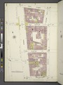 Manhattan, V. 2, Plate No. 1 (Map bounded by 1st St., Chrystie St., Rivington St., Bowery) NYPL1996101.tiff 5,383 × 7,177, 2 pages; 110.59 MB
-
 Manhattan, V. 2, Plate No. 2 (Map bounded by 1st St., Allen St., Rivington St., Chrystie St.) NYPL1996102.tiff 5,399 × 7,198, 2 pages; 111.25 MB
-
 Manhattan, V. 2, Plate No. 3 (Map bounded by 1st St., Essex St., Rivington St., Allen St.) NYPL1996103.tiff 5,383 × 7,177, 2 pages; 110.59 MB
-
 Manhattan, V. 2, Plate No. 4 (Map bounded by Houston St., Clinton St., Rivington St., Essex St.) NYPL1996104.tiff 5,391 × 7,189, 2 pages; 110.94 MB
-
 Manhattan, V. 2, Plate No. 5 (Map bounded by 2nd St., Pitt St., Rivington St., Clinton St.) NYPL1996105.tiff 5,321 × 7,094, 2 pages; 108.06 MB
-
 Manhattan, V. 2, Plate No. 6 (Map bounded by 2nd St., Columbia St., Rivington St., Pitt St.) NYPL1996106.tiff 5,391 × 7,189, 2 pages; 110.94 MB
-
 Manhattan, V. 2, Plate No. 7 (Map bounded by E. 3rd St., Goerck St., Rivington St., Columbia St.) NYPL1996107.tiff 5,349 × 7,132, 2 pages; 109.21 MB
-
 Manhattan, V. 2, Plate No. 8 (Map bounded by E. 3rd St., East River, Rivington St., Goerck St.) NYPL1996108.tiff 5,403 × 7,204, 2 pages; 111.42 MB
-
 Manhattan, V. 2, Plate No. 9 (Map bounded by 5th St., 2nd Ave., 1st St., Bowery) NYPL1996109.tiff 5,309 × 7,079, 2 pages; 107.59 MB
-
 Manhattan, V. 2, Plate No. 10 (Map bounded by 5th St., 1st Ave., 1st St., 2nd Ave.) NYPL1996110.tiff 5,403 × 7,204, 2 pages; 111.42 MB
-
 Manhattan, V. 2, Plate No. 11 (Map bounded by 5th St., Avenue A, 1st St., 1st Ave.) NYPL1996111.tiff 5,305 × 7,073, 2 pages; 107.41 MB
-
 Manhattan, V. 2, Plate No. 12 (Map bounded by 5th St., Avenue B, E. Houston St., Avenue A) NYPL1996112.tiff 5,408 × 7,210, 2 pages; 111.62 MB
-
 Manhattan, V. 2, Plate No. 13 (Map bounded by 6th St., Avenue C, 2nd St., Avenue B) NYPL1996113.tiff 5,321 × 7,095, 2 pages; 108.07 MB
-
 Manhattan, V. 2, Plate No. 14 (Map bounded by 6th St., Avenue D, 2nd St., Avenue C) NYPL1996114.tiff 5,408 × 7,210, 2 pages; 111.62 MB
-
 Manhattan, V. 2, Plate No. 15 (Map bounded by Avenue D, 6th St., Marginal St., E. 3rd St.) NYPL1996115.tiff 5,340 × 7,120, 2 pages; 108.84 MB
-
 Manhattan, V. 2, Plate No. 16 (Map bounded by Avenue D, E. 9th St., Tompkins St., 6th St.) NYPL1996116.tiff 5,408 × 7,210, 2 pages; 111.62 MB
-
 Manhattan, V. 2, Plate No. 17 (Map bounded by E. 10th St., 3rd Ave., 4th Ave.) NYPL1996117.tiff 5,354 × 7,138, 2 pages; 109.4 MB
-
 Manhattan, V. 2, Plate No. 18 (Map bounded by E. 10th St., 2nd Ave., 5th St., 3rd Ave.) NYPL1996118.tiff 5,396 × 7,194, 2 pages; 111.12 MB
-
 Manhattan, V. 2, Plate No. 19 (Map bounded by E. 10th St., 1st Ave., 5th St., 2nd Ave.) NYPL1996119.tiff 5,354 × 7,138, 2 pages; 109.4 MB
-
 Manhattan, V. 2, Plate No. 20 (Map bounded by E. 10th St., Avenue A, 5th St., 1st Ave.) NYPL1996120.tiff 5,403 × 7,204, 2 pages; 111.42 MB
-
 Manhattan, V. 2, Plate No. 21 (Map bounded by E. 10th St., Avenue B, 5th St., Avenue A) NYPL1996121.tiff 5,381 × 7,174, 2 pages; 110.51 MB
-
 Manhattan, V. 2, Plate No. 22 (Map bounded by E. 11th St., Avenue C, 6th St., Avenue B) NYPL1996122.tiff 5,380 × 7,174, 2 pages; 110.49 MB
-
 Manhattan, V. 2, Plate No. 23 (Map bounded by E. 11th St., Avenue D, 6th St., Avenue C) NYPL1996123.tiff 5,381 × 7,174, 2 pages; 110.51 MB
-
 Manhattan, V. 2, Plate No. 24 (Map bounded by E. 13th St., East River, E. 9th St., Avenue D) NYPL1996124.tiff 5,373 × 7,164, 2 pages; 110.19 MB
-
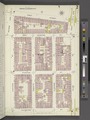
 Manhattan, V. 2, Plate No. 25 (Map bounded by E. 14th St., 3rd Ave., E. 10th St., 4th Ave.) NYPL1996125.tiff 5,381 × 7,174, 2 pages; 110.51 MB
-
 Manhattan, V. 2, Plate No. 26 (Map bounded by E. 14th St., 2nd Ave., E. 10th St., 3rd Ave.) NYPL1996126.tiff 5,373 × 7,164, 2 pages; 110.19 MB
-
 Manhattan, V. 2, Plate No. 27 (Map bounded by E. 14th St., 1st Ave., E. 10th St., 2nd Ave.) NYPL1996127.tiff 5,381 × 7,174, 2 pages; 110.51 MB
-
 Manhattan, V. 2, Plate No. 28 (Map bounded by E. 14th St., Avenue A, E. 10th St., 1st Ave.) NYPL1996128.tiff 5,373 × 7,164, 2 pages; 110.19 MB
-
 Manhattan, V. 2, Plate No. 29 (Map bounded by E. 14th St., Avenue B, E. 10th St., Avenue A) NYPL1996129.tiff 5,381 × 7,174, 2 pages; 110.51 MB
-
 Manhattan, V. 2, Plate No. 30 (Map bounded by E. 15th St., Avenue C, E. 11th St., Avenue B) NYPL1996130.tiff 5,373 × 7,164, 2 pages; 110.19 MB
-
 Manhattan, V. 2, Plate No. 31 (Map bounded by E. 15th St., Avenue D, E. 11th St., Avenue C) NYPL1996131.tiff 5,387 × 7,183, 2 pages; 110.77 MB
-
 Manhattan, V. 2, Plate No. 32 (Map bounded by E. 17th St., Avenue D, E. 13th St., Avenue C) NYPL1996132.tiff 5,361 × 7,148, 2 pages; 109.7 MB
-
 Manhattan, V. 2, Plate No. 33 (Map bounded by 6th Ave., W. 17th St., 5th Ave., W. 14th St.) NYPL1996133.tiff 5,387 × 7,183, 2 pages; 110.77 MB
-
 Manhattan, V. 2, Plate No. 34 (Map bounded by 5th Ave., E. 17th St., Union East., E. 14th St.) NYPL1996134.tiff 5,342 × 7,123, 2 pages; 108.93 MB
-
 Manhattan, V. 2, Plate No. 35 (Map bounded by Union Sq. East, E. 17th St., 3rd Ave., E. 14th St.) NYPL1996135.tiff 5,387 × 7,183, 2 pages; 110.77 MB
-
 Manhattan, V. 2, Plate No. 36 (Map bounded by E. 18th St., 2nd Ave., E. 14th St., 3rd Ave.) NYPL1996136.tiff 5,373 × 7,164, 2 pages; 110.19 MB
-
 Manhattan, V. 2, Plate No. 37 (Map bounded by E. 18th St., 1st Ave., E. 14th St., 2nd Ave.) NYPL1996137.tiff 5,387 × 7,183, 2 pages; 110.77 MB
-
 Manhattan, V. 2, Plate No. 38 (Map bounded by E. 18th St., Avenue A, E. 14th St., 1st Ave.) NYPL1996138.tiff 5,373 × 7,164, 2 pages; 110.19 MB
-
 Manhattan, V. 2, Plate No. 39 (Map bounded by E. 18th St., Avenue B, E. 14th St., Avenue A) NYPL1996139.tiff 5,363 × 7,151, 2 pages; 109.78 MB
-
 Manhattan, V. 2, Plate No. 40 (Map bounded by E. 20th St., Avenue C, E. 15th St., Avenue B) NYPL1996140.tiff 5,373 × 7,164, 2 pages; 110.19 MB
-
 Manhattan, V. 2, Plate No. 41 (Map bounded by 6th Ave., W. 20th St., 5th Ave., W. 17th St.) NYPL1996141.tiff 5,363 × 7,151, 2 pages; 109.78 MB
-
 Manhattan, V. 2, Plate No. 42 (Map bounded by 6th Ave., W. 22nd St., 5th Ave., W. 20th St.) NYPL1996142.tiff 5,373 × 7,164, 2 pages; 110.19 MB
-
 Manhattan, V. 2, Plate No. 43 (Map bounded by E. 22nd St., Broadway, E. 17th St., 5th Ave.) NYPL1996143.tiff 5,363 × 7,151, 2 pages; 109.78 MB
-
 Manhattan, V. 2, Plate No. 44 (Map bounded by E. 22nd St., 4th Ave., E. 17th St., Broadway) NYPL1996144.tiff 5,381 × 7,175, 2 pages; 110.52 MB
-
 Manhattan, V. 2, Plate No. 45 (Map bounded by E. 22nd St., Irving Place, E. 17th St., 4th Ave.) NYPL1996145.tiff 5,363 × 7,151, 2 pages; 109.78 MB
-
 Manhattan, V. 2, Plate No. 46 (Map bounded by E. 22nd St., 3rd Ave., E. 17th St., Irving Place) NYPL1996146.tiff 5,381 × 7,175, 2 pages; 110.52 MB
-
 Manhattan, V. 2, Plate No. 47 (Map bounded by E. 22nd St., 2nd Ave., E. 18th St., 3rd Ave.) NYPL1996147.tiff 5,404 × 7,206, 2 pages; 111.47 MB
-
 Manhattan, V. 2, Plate No. 48 (Map bounded by E. 22nd St., 1st Ave., E. 18th St., 2nd Ave.) NYPL1996148.tiff 5,381 × 7,175, 2 pages; 110.52 MB
-
 Manhattan, V. 2, Plate No. 49 (Map bounded by E. 22nd St., Avenue A, E. 18th St., 1st Ave.) NYPL1996149.tiff 5,386 × 7,181, 2 pages; 110.72 MB
-
 Manhattan, V. 2, Plate No. 50 (Map bounded by E. 22nd St., Avenue B, E. 18th St., Avenue A) NYPL1996150.tiff 5,381 × 7,175, 2 pages; 110.52 MB
-
 Manhattan, V. 2, Plate No. 51 (Map bounded by East River, Rivington St.) NYPL1996151.tiff 5,386 × 7,181, 2 pages; 110.72 MB
-
 Manhattan, V. 2, Plate No. 52 (Map bounded by East River, 3rd St., 7th St.) NYPL1996152.tiff 5,381 × 7,175, 2 pages; 110.52 MB
-
 Manhattan, V. 2, Plate No. 53 (Map bounded by East River, Marginal St.) NYPL1996153.tiff 5,386 × 7,181, 2 pages; 110.72 MB
-
 Manhattan, V. 2, Plate No. 54 (Map bounded by East River, E. 11th St., E. 15th St.) NYPL1996154.tiff 5,381 × 7,175, 2 pages; 110.52 MB
-
 Manhattan, V. 2, Plate No. 55 (Map bounded by East River, E. 15th St., Avenue E) NYPL1996155.tiff 5,386 × 7,181, 2 pages; 110.72 MB
-
 Manhattan, V. 2, Plate No. 56 (Map bounded by East River, Marfinal St.) NYPL1996156.tiff 5,381 × 7,175, 2 pages; 110.52 MB