Category:Stubwieswipfel
Jump to navigation
Jump to search
mountain in the Totes Gebirge in Upper Austria  | |||||
| Upload media | |||||
| Instance of | |||||
|---|---|---|---|---|---|
| Location | Spital am Pyhrn, Kirchdorf District, Upper Austria, Austria | ||||
| Mountain range | |||||
| Elevation above sea level |
| ||||
 | |||||
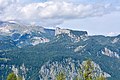
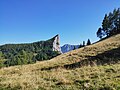
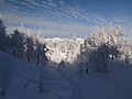
Deutsch: Der Stubwieswipfel (1786 m) befindet sich in östlichen Teil des Toten Gebirges auf dem Gebiet der Gemeinde Spital am Pyhrn.
English: Stubwieswipfel (1786 m) is located in the eastern part of the mountain ridge Totes Gebirge in the local authority area of Spital am Pyhrn.
Media in category "Stubwieswipfel"
The following 25 files are in this category, out of 25 total.
-
 Linzer Haus Wurzeralm1.jpg 4,708 × 3,135; 4.4 MB
-
 Ramesch Totes Gebirge 20051029c.jpg 2,272 × 1,704; 1.34 MB
-
 Sengsengebirge from Stubwieswipfel.jpg 3,648 × 2,048; 2.32 MB
-
 Snow-covered trees near Stubwieswipfel, Totes Gebirge (1).jpg 3,648 × 2,736; 2.53 MB
-
 Snow-covered trees near Stubwieswipfel, Totes Gebirge (2).jpg 3,648 × 2,736; 4.67 MB
-
 Snow-covered trees near Stubwieswipfel, Totes Gebirge (3).jpg 2,736 × 3,648; 2.51 MB
-
 Snow-covered trees near Stubwieswipfel, Totes Gebirge, (4).jpg 3,648 × 2,736; 5.04 MB
-
 Snow-covered trees near Stubwieswipfel, Totes Gebirge, (5).jpg 3,648 × 2,736; 4.89 MB
-
 Spital am Pyhrn Stubwies Naturfreundehaus Wurzeralm.jpg 5,817 × 3,938; 6.06 MB
-
 Spital am Pyhrn, Hals-Sattel (2).jpg 4,896 × 3,672; 4.89 MB
-
 Spital aP Warscheneckgebiet Arlingsattel.jpg 6,000 × 4,000; 9.32 MB
-
 Stubwies Arlingsattel.jpg 6,000 × 4,000; 9.27 MB
-
 Stubwieswifel 360° Panorama.jpg 4,482 × 1,024; 5.81 MB
-
 Stubwieswifel.jpg 1,024 × 683; 274 KB
-
 Stubwieswipfel 20060203a.jpg 2,272 × 1,704; 1.94 MB
-
 Stubwieswipfel Schwarzeck Wurzeralm.JPG 4,288 × 2,848; 3.1 MB
-
 Stubwieswipfel Totes Gebirge 20050205a.jpg 2,048 × 1,536; 2.83 MB
-
 Stubwieswipfel winter.jpg 3,648 × 2,048; 4.49 MB
-
 Stubwieswipfel Wurzeralm 20060203a.jpg 2,272 × 1,704; 887 KB
-
 Stubwieswipfel ze sedla.jpg 4,080 × 3,072; 6.12 MB
-
 Stubwieswipfel20210213.jpg 4,608 × 3,456; 4.18 MB
-
 Totes Gebirge winter.jpg 3,648 × 2,736; 2.19 MB
-
 Warscheneck winter.jpg 3,648 × 2,048; 4.68 MB
-
 Wolken über der Wurzeralm 20070623.jpg 3,607 × 1,679; 3.39 MB
-
 Wurzeralm02.jpg 2,272 × 1,704; 2.66 MB


.jpg)
.jpg)
.jpg)
.jpg)
.jpg)
.jpg)


