Category:Streets in Oxford
Jump to navigation
Jump to search
Wikimedia category | |||||
| Upload media | |||||
| Instance of | |||||
|---|---|---|---|---|---|
| Category combines topics | |||||
| Oxford | |||||
city in Oxfordshire, England      | |||||
| Pronunciation audio | |||||
| Instance of |
| ||||
| Patron saint | |||||
| Location | Oxford, Oxfordshire, South East England, England | ||||
| Located in or next to body of water | |||||
| Inception |
| ||||
| Significant event |
| ||||
| Population |
| ||||
| Area |
| ||||
| Different from | |||||
| official website | |||||
 | |||||
Streets in Oxford
Subcategories
This category has the following 2 subcategories, out of 2 total.
*
Media in category "Streets in Oxford"
The following 200 files are in this category, out of 225 total.
(previous page) (next page)-
 Abbey Road - geograph.org.uk - 1408070.jpg 640 × 480; 77 KB
-

-

-
 Abbey Walk - Osney Lane - geograph.org.uk - 3605325.jpg 480 × 640; 78 KB
-
 Across Quaking Bridge, Oxford - geograph.org.uk - 3400315.jpg 640 × 503; 106 KB
-
 Adelaide Street, Oxford - geograph.org.uk - 2726231.jpg 2,000 × 1,336; 488 KB
-
 AlexanderDennis Enviro200 SN10 CCX Cowley.jpg 1,280 × 1,023; 606 KB
-
 Alexandra Road - Oxford - geograph.org.uk - 313311.jpg 640 × 480; 90 KB
-
 Alexandra Road seen from New Botley recreation ground - geograph.org.uk - 5855916.jpg 5,184 × 3,456; 3.09 MB
-
 Alfred Street - High Street - geograph.org.uk - 3602486.jpg 480 × 640; 91 KB
-
 Alley to the river - geograph.org.uk - 1103023.jpg 640 × 480; 58 KB
-
 Alma Place - geograph.org.uk - 3967224.jpg 640 × 430; 77 KB
-
 Annesley Road, Rose Hill - geograph.org.uk - 3871926.jpg 1,600 × 1,200; 449 KB
-
 Aristotle Lane canal bridge - geograph.org.uk - 1751884.jpg 1,500 × 1,000; 265 KB
-
 Atterbury Rd - geograph.org.uk - 3948350.jpg 640 × 430; 77 KB
-
 Back down the mead - geograph.org.uk - 1103285.jpg 640 × 480; 57 KB
-
 Bailey Road - geograph.org.uk - 1090563.jpg 640 × 480; 63 KB
-
 Bardwell Rd - geograph.org.uk - 4001584.jpg 640 × 430; 72 KB
-
 Barracks Lane - geograph.org.uk - 3329986.jpg 1,024 × 683; 161 KB
-
 Barrett Street - Mill Street - geograph.org.uk - 3605295.jpg 640 × 480; 68 KB
-
 Bartlemas Road - geograph.org.uk - 3314720.jpg 640 × 425; 74 KB
-
 Bartlemas Road - geograph.org.uk - 3314721.jpg 640 × 425; 75 KB
-

-
 Becket Street - Osney Lane - geograph.org.uk - 3605408.jpg 640 × 480; 71 KB
-
 Becket Street from the bridge - geograph.org.uk - 1382501.jpg 450 × 600; 56 KB
-
 Beechcoft Road, Oxford.JPG 4,288 × 3,216; 3.13 MB
-
 Biking past - geograph.org.uk - 1408270.jpg 640 × 480; 62 KB
-
 Binsey Lane - Oxford - geograph.org.uk - 313305.jpg 640 × 480; 90 KB
-
 Bridge Street Osney - geograph.org.uk - 1590405.jpg 640 × 480; 60 KB
-
 Bulwarks Lane - geograph.org.uk - 2113961.jpg 600 × 800; 105 KB
-
 Bus IMG 0896 (15735611524).jpg 2,288 × 1,716; 946 KB
-
 Bus img 4075 (15991408677) (2).jpg 2,549 × 1,912; 1.58 MB
-
 Busses in Oxford (5563404377).jpg 3,264 × 1,952; 1.64 MB
-
 Campbell Road, Cowley - geograph.org.uk - 3244945.jpg 2,560 × 1,920; 768 KB
-
 Car electronics - geograph.org.uk - 1103281.jpg 640 × 480; 66 KB
-
 Cardigan Street - geograph.org.uk - 2008972.jpg 1,600 × 1,067; 701 KB
-
 Cardigan Street - geograph.org.uk - 504217.jpg 640 × 426; 283 KB
-
 Cardigan Street, Jericho, Oxford - geograph.org.uk - 4088897.jpg 800 × 585; 106 KB
-
 Cardigan Street, Jericho, Oxford - geograph.org.uk - 4090016.jpg 800 × 597; 119 KB
-
 Castle Tavern - geograph.org.uk - 2787291.jpg 800 × 600; 141 KB
-
 Catherine St - geograph.org.uk - 3953109.jpg 640 × 430; 68 KB
-
 Catherine St - geograph.org.uk - 3958814.jpg 640 × 430; 69 KB
-
 Cecil Sharp Place, Headington - geograph.org.uk - 1220260.jpg 640 × 480; 69 KB
-
 Centre Mead - geograph.org.uk - 1102955.jpg 640 × 480; 63 KB
-
 Charles St - geograph.org.uk - 3953111.jpg 640 × 430; 68 KB
-
 Charles St - geograph.org.uk - 3953117.jpg 640 × 430; 75 KB
-
 Chucking it down - geograph.org.uk - 1410504.jpg 640 × 480; 82 KB
-
 Church Walk looking west, Oxford.JPG 4,288 × 3,216; 3.69 MB
-
 Church Walk, Oxford.JPG 4,288 × 3,216; 3.51 MB
-
 Circus Street - geograph.org.uk - 3314740.jpg 640 × 425; 73 KB
-
 Circus Street - geograph.org.uk - 722928.jpg 640 × 480; 59 KB
-
 Circus Street, Oxford - geograph.org.uk - 4835771.jpg 2,304 × 1,728; 847 KB
-
 City Sightseeing bus in Oxford, England 03 - Butterwyke Place.jpg 3,072 × 2,304; 2.42 MB
-
 Community litter-picking at Waterways - geograph.org.uk - 1740343.jpg 3,872 × 2,592; 3.67 MB
-

-
 Conservative Party Archive Oxford.jpg 2,592 × 1,944; 813 KB
-
 Coppock Close, Headington Quarry - geograph.org.uk - 3323572.jpg 1,600 × 1,174; 298 KB
-
 Corner of Wellington Street and Nelson Street - geograph.org.uk - 2181755.jpg 1,000 × 632; 126 KB
-
 Cowley Place - geograph.org.uk - 3967246.jpg 640 × 430; 74 KB
-
 Cowley StLuke Wright Streetdeck.jpg 1,268 × 1,280; 716 KB
-
 Between Towns Road - geograph.org.uk - 1090595.jpg 640 × 480; 61 KB
-
 Cranham Street - geograph.org.uk - 2007692.jpg 1,600 × 1,042; 521 KB
-
 Cranham Street Jericho Oxford.JPG 2,048 × 1,536; 1.38 MB
-
 Cycle Parking, Saint Giles - geograph.org.uk - 2009168.jpg 1,600 × 1,099; 817 KB
-
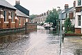
 Earl Street, 2007 floods - geograph.org.uk - 5856720.jpg 1,840 × 1,232; 918 KB
-
 Earl Street, 2007 floods - geograph.org.uk - 5856741.jpg 1,840 × 1,232; 919 KB
-
 Earl Street, 2007 floods - geograph.org.uk - 5856750.jpg 1,840 × 1,232; 1,007 KB
-
 East on Walton Well Road, Oxford.jpg 3,600 × 2,160; 1.06 MB
-
 EF International Academy, Oxford Campus.JPG 4,288 × 3,216; 3.96 MB
-
 Elmthorpe Rd - geograph.org.uk - 5618198.jpg 640 × 426; 69 KB
-
 ENG Oxford Alma Lane 01.jpg 4,008 × 3,006; 1.41 MB
-
 ENG Oxford Bartlemas Close 01.jpg 4,032 × 3,024; 3.76 MB
-
 ENG Oxford Between Towns Road 01.jpg 4,032 × 3,024; 1.51 MB
-
 ENG Oxford Bullingdon Road 02.jpg 4,032 × 3,024; 1.29 MB
-
 ENG Oxford Cheney Lane 02.jpg 3,918 × 2,939; 2.13 MB
-
 ENG Oxford Crescent Road 001.jpg 4,032 × 3,024; 1.26 MB
-
 ENG Oxford Crescent Road 003.jpg 4,032 × 3,024; 1.14 MB
-
 ENG Oxford Dawson Street 01.jpg 4,032 × 3,024; 728 KB
-
 ENG Oxford Divinity Road 01.jpg 4,016 × 3,012; 1.67 MB
-
 ENG Oxford Divinity Road 03.jpg 4,016 × 3,012; 2.67 MB
-
 ENG Oxford Divinity Road 04.jpg 3,918 × 2,939; 2.68 MB
-
 ENG Oxford Divinity Road 11.jpg 4,016 × 3,012; 2.53 MB
-
 ENG Oxford Divinity Road 12.jpg 4,016 × 3,012; 1.89 MB
-
 ENG Oxford Finch Close 01.jpg 4,032 × 3,024; 2.72 MB
-
 ENG Oxford Gipsy Lane 02.jpg 4,032 × 3,024; 1.79 MB
-
 ENG Oxford Headington Road 01.jpg 3,024 × 4,032; 3.39 MB
-
 ENG Oxford Headington Road 06.jpg 4,032 × 3,024; 2.57 MB
-
 ENG Oxford Headington Road 09.jpg 4,032 × 3,024; 2.03 MB
-
 ENG Oxford Headington Road 11.jpg 4,032 × 3,024; 2.58 MB
-
 ENG Oxford Hilltop Road 05.jpg 4,032 × 3,024; 2.41 MB
-
 ENG Oxford Hilltop Road 06.jpg 4,008 × 3,006; 2.02 MB
-
 ENG Oxford Old High Street 01.jpg 4,032 × 3,024; 1.45 MB
-
 ENG Oxford Rose Lane 03.jpg 4,016 × 3,012; 2.12 MB
-
 ENG Oxford Salegate Lane 01.jpg 4,008 × 3,006; 2.22 MB
-
 ENG Oxford Unidentified 012.jpg 3,955 × 2,966; 1.95 MB
-
 ENG Oxford Unidentified 014.jpg 4,032 × 3,024; 1.82 MB
-
 ENG Oxford Unidentified 04.jpg 4,032 × 3,024; 701 KB
-
 ENG Oxford Unidentified 05.jpg 4,032 × 3,024; 1.07 MB
-
 ENG Oxford Union Street 01.jpg 4,032 × 3,024; 1.82 MB
-
 Entrance to Cotuit Hall on Pullens Lane, Oxford.JPG 4,288 × 3,216; 3.7 MB
-
 Entrance to University College annex, Oxford.JPG 4,288 × 3,216; 3.79 MB
-
 Far From the Madding Crowd - geograph.org.uk - 1416231.jpg 450 × 600; 62 KB
-
 Five Mile Drive blossom - geograph.org.uk - 717086.jpg 480 × 640; 153 KB
-
 Floyd's Row - geograph.org.uk - 5561704.jpg 640 × 426; 61 KB
-
 Fox Crescent - geograph.org.uk - 5515294.jpg 640 × 426; 68 KB
-
 Foxwell Drive - geograph.org.uk - 1087377.jpg 640 × 480; 64 KB
-
 Friars Entry - geograph.org.uk - 1457202.jpg 480 × 640; 88 KB
-
 Friars Entry Scene - geograph.org.uk - 1457207.jpg 480 × 640; 69 KB
-
 Friars Wharf - geograph.org.uk - 1391051.jpg 640 × 480; 85 KB
-
 Ghost Bike Oxford.jpg 2,686 × 1,873; 3.54 MB
-
 Goldfrapp Oxford (4687027821).jpg 3,872 × 2,592; 2.67 MB
-
 Grunsell Close, Headington - geograph.org.uk - 338758.jpg 640 × 390; 59 KB
-
 Harley Road - Oxford - geograph.org.uk - 313319.jpg 640 × 480; 103 KB
-
 Harpsichord Place, Oxford - geograph.org.uk - 1399546.jpg 640 × 480; 107 KB
-
 St Andrew's Church - geograph.org.uk - 1087392.jpg 640 × 480; 68 KB
-
 Helen Road - Oxford - geograph.org.uk - 313299.jpg 640 × 480; 90 KB
-
 Helen Road, 2007 floods - geograph.org.uk - 5856388.jpg 1,840 × 1,232; 906 KB
-
 Helen Road, 2007 floods - geograph.org.uk - 5856763.jpg 1,840 × 1,232; 1,016 KB
-
 Holly Bush Row - geograph.org.uk - 1408202.jpg 640 × 480; 68 KB
-
 Howard St - geograph.org.uk - 3953100.jpg 640 × 430; 95 KB
-
 Howard St - geograph.org.uk - 3953106.jpg 640 × 430; 78 KB
-
 Hubble Close - geograph.org.uk - 337561.jpg 640 × 480; 191 KB
-
 Inott Furze, Headington - geograph.org.uk - 325469.jpg 640 × 480; 76 KB
-
 Jubilee Street Party in Jericho, Oxford.JPG 3,456 × 5,184; 6.26 MB
-
 Kendal Crescent Shops - geograph.org.uk - 51929.jpg 640 × 427; 34 KB
-
 Lamb and Flag Passage - geograph.org.uk - 719486.jpg 480 × 640; 120 KB
-
 Lamb and flag passage in Oxford.jpg 3,264 × 2,448; 2.86 MB
-
 Lamb ^ Flag Passage - geograph.org.uk - 4328375.jpg 600 × 800; 112 KB
-
 Lane by the house - geograph.org.uk - 1384031.jpg 450 × 600; 65 KB
-
 Lane in Oxford.jpg 2,336 × 3,504; 3.87 MB
-
 Last part of the mead - geograph.org.uk - 1103175.jpg 640 × 480; 56 KB
-
 Lights on Park End - geograph.org.uk - 1403535.jpg 640 × 480; 60 KB
-
 Lomooxford.jpg 800 × 530; 125 KB
-
 Looking at Barrett street - geograph.org.uk - 1380870.jpg 450 × 600; 53 KB
-
 Looking back down the lane - geograph.org.uk - 1384099.jpg 450 × 600; 63 KB
-
 Looking down the place - geograph.org.uk - 1385706.jpg 640 × 480; 79 KB
-
 Looking down the street - geograph.org.uk - 1407073.jpg 640 × 480; 73 KB
-
 Looking east along Church Walk, Oxford.JPG 4,288 × 3,216; 3.83 MB
-
 Looking past the gate - geograph.org.uk - 1385945.jpg 640 × 480; 70 KB
-
 Looking past the gates - geograph.org.uk - 1385791.jpg 640 × 480; 78 KB
-
 Looking up Divinity road - geograph.org.uk - 767458.jpg 640 × 480; 90 KB
-
 Looking west along Church Walk, Oxford.JPG 4,288 × 3,216; 3.48 MB
-
 Looking west along Walton Well Road, Oxford.JPG 4,288 × 3,216; 3.63 MB
-
 Magdalene College from St. Giles. Wellcome L0002244.jpg 1,616 × 1,186; 1 MB
-
 Middle Way, Summertown, Oxford (6544823393).jpg 3,150 × 2,393; 2.25 MB
-
 Morris Dancers at Jericho Street Fair Oxford.JPG 5,184 × 3,456; 6.76 MB
-
-
 Navigation Way - geograph.org.uk - 1758107.jpg 1,500 × 971; 176 KB
-
 New building along the street - geograph.org.uk - 1385735.jpg 450 × 600; 51 KB
-
 New College School Oxford pupils in regalia.jpg 320 × 240; 18 KB
-
 NewMarston StMichael&AllAngels southeast.JPG 2,950 × 1,967; 2.03 MB
-
 NewMarston StMichael&AllAngels southwest.JPG 2,880 × 1,920; 2.24 MB
-
 Norfolk Street - geograph.org.uk - 2787272.jpg 800 × 600; 138 KB
-
 Oatlands Road - Oxford - geograph.org.uk - 313314.jpg 640 × 480; 104 KB
-
 Oatlands Road, Oxford under snow - geograph.org.uk - 4425341.jpg 640 × 480; 199 KB
-
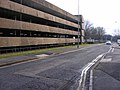
 Westgate multi-storey - geograph.org.uk - 1410423.jpg 640 × 480; 97 KB
-
 Old High St, Headington - geograph.org.uk - 1385769.jpg 640 × 480; 76 KB
-
 Osney Lane - geograph.org.uk - 1382512.jpg 450 × 600; 66 KB
-
 Osney Lane - geograph.org.uk - 1412482.jpg 450 × 600; 51 KB
-
 Osney Mead, Oxford - geograph.org.uk - 1391160.jpg 640 × 426; 78 KB
-
 Other side of the school - geograph.org.uk - 1415905.jpg 640 × 480; 66 KB
-
 Modern post box in Tackley Place - geograph.org.uk - 1760570.jpg 1,500 × 1,000; 216 KB
-
 Oxford - Rose Lane - Merton College T.S. Eliot Theatre 2010 01.jpg 3,532 × 1,903; 7.46 MB
-
 Oxford - Rose Lane - Merton College T.S. Eliot Theatre 2010 02.jpg 5,832 × 3,887; 17.51 MB
-
 Oxford - Rose Lane - Merton College T.S. Eliot Theatre 2010 03.jpg 5,746 × 3,830; 18.13 MB
-
 Oxford - Rose Lane - View ENE on University of Oxford Botanic Garden & Magdalen Tower 1509.jpg 5,746 × 3,830; 18.57 MB
-

-

-
-
 Oxford - Rose Lane - View SSW - In the back Merton College T.S. Eliot Theatre 2010.jpg 5,891 × 3,926; 19.59 MB
-
-

-
 Oxford's streets.jpg 1,518 × 1,029; 253 KB
-
 Oxford, Fry's Hill - geograph.org.uk - 661887.jpg 640 × 480; 69 KB
-
 SS. Philip and James - geograph.org.uk - 10054.jpg 635 × 640; 190 KB
-
 Oxford. - geograph.org.uk - 148318.jpg 640 × 428; 281 KB
-
 Park End - geograph.org.uk - 1408095.jpg 640 × 480; 71 KB
-
 Parks road next broad street.jpg 1,944 × 2,592; 780 KB
-
 PlaxtonPresident PJ02PZN NewHeadington.jpg 839 × 598; 283 KB
-
 Richmond Road, Oxford, May 2023.jpg 4,032 × 3,024; 7.68 MB
-
 Ridgefield Road - geograph.org.uk - 774466.jpg 640 × 480; 54 KB
-
 Ridgefield Road - geograph.org.uk - 774474.jpg 640 × 480; 61 KB
-

-
 Shaftesbury Road, Barton - geograph.org.uk - 338760.jpg 640 × 420; 57 KB
-
 Shirelake Close - geograph.org.uk - 1410489.jpg 640 × 480; 102 KB
-
 Shoe Lane, Oxford.jpg 3,264 × 2,448; 2.89 MB
-
 Short street - geograph.org.uk - 1384126.jpg 450 × 600; 83 KB
-
 Snowy Oxford on November 24 2010.JPG 1,797 × 1,208; 2.25 MB
-
 Southmoor Place from Kingston Road - geograph.org.uk - 1760568.jpg 1,500 × 1,000; 159 KB
-
 St Hugh's College, Oxford - rear gates.JPG 2,592 × 1,944; 997 KB
-
 St John's College playing field, Bainton Road, Oxford.JPG 4,288 × 3,216; 3.82 MB
-
 St Thomas Street - geograph.org.uk - 1384120.jpg 450 × 600; 75 KB
-
 St Thomas Street towards the Gaol - geograph.org.uk - 1392766.jpg 450 × 600; 61 KB
-
 St Thomas' Street - geograph.org.uk - 2108886.jpg 800 × 600; 112 KB
-
 Stapleton Road - geograph.org.uk - 1416534.jpg 640 × 480; 79 KB
-
 Starting to rain - geograph.org.uk - 1410499.jpg 640 × 480; 81 KB
-
 Stubbs Avenue - geograph.org.uk - 772424.jpg 640 × 480; 47 KB
-
 Thames Street - geograph.org.uk - 1410472.jpg 640 × 480; 84 KB
-
 The Bear, Alfred Street, Oxford - geograph.org.uk - 2308918.jpg 800 × 562; 437 KB
-


.jpg)
_(2).jpg)
.jpg)


.jpg)


.jpg)


.jpg)


