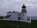
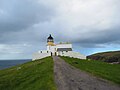
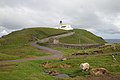
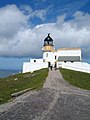
Category:Stoer Head Lighthouse
Jump to navigation
Jump to search

| Object location | | View all coordinates using: OpenStreetMap |
|---|
English: Stoer Head Lighthouse
lighthouse in Sutherland, Scotland  Stoer Head Lighthouse 2016 | |||||
| Upload media | |||||
| Instance of | |||||
|---|---|---|---|---|---|
| Made from material | |||||
| Location | |||||
| Owned by | |||||
| Operator | |||||
| Heritage designation |
| ||||
| Inception |
| ||||
| Significant event |
| ||||
| Source of energy | |||||
| Height |
| ||||
| official website | |||||
 | |||||
|
This is a category about listed building number 1833. |
Media in category "Stoer Head Lighthouse"
The following 45 files are in this category, out of 45 total.
-
 2011 Schotland Stoer Head lighthouse 30-05-2011 13-12-48.png 3,706 × 2,316; 11.75 MB
-
 2011 Schotland Stoer Head lighthouse 30-05-2011 16-41-46.png 3,706 × 2,316; 12.65 MB
-
 2011 Sutherland Stoer Head lighthouse 30-05-2011 13-12-48.jpg 3,706 × 2,316; 1.18 MB
-
 2011 Sutherland Stoer Head lighthouse 30-05-2011 16-41-46.jpg 3,706 × 2,316; 1.49 MB
-

-
 Cliffs at the Point of Stoer - geograph.org.uk - 2003170.jpg 960 × 643; 172 KB
-
 Cliffs by Stoer Lighthouse - geograph.org.uk - 995432.jpg 640 × 429; 48 KB
-
 Cluas Deas Lighthouse (geograph 2143953).jpg 640 × 480; 25 KB
-
 Coastline towards Stoer lighthouse - geograph.org.uk - 448957.jpg 640 × 427; 63 KB
-
 Le phare de Stoer Head, Écosse.jpg 4,608 × 3,456; 1.4 MB
-
 Metal Cross at Stoer Lighthouse - geograph.org.uk - 2663267.jpg 425 × 640; 99 KB
-
 Ordnance Survey One-Inch Sheet 13 Loch Inver & Loch Assynt, Published 1959.jpg 7,750 × 9,218; 10.28 MB
-
 Point of Stoer Lighthouse - geograph.org.uk - 949189.jpg 640 × 431; 51 KB
-
 Point of Stoer Lighthouse, Sutherland, Scotland-14April2011 (1).jpg 3,810 × 2,366; 1.42 MB
-
 Point of Stoer Lighthouse, Sutherland, Scotland-14April2011 (2).jpg 4,288 × 2,848; 1.4 MB
-
 Point of Stoer Lighthouse, Sutherland, Scotland-14April2011.jpg 3,810 × 2,366; 1.47 MB
-
 Sea cliffs north of Stoer Lighthouse - geograph.org.uk - 878049.jpg 640 × 439; 54 KB
-

-

-

-
 Stoer Head Lighthouse (4062034164).jpg 1,600 × 1,065; 126 KB
-
 Stoer Head Lighthouse (7955442614).jpg 1,280 × 960; 719 KB
-
 Stoer Head lighthouse - geograph.org.uk - 2037646.jpg 3,296 × 2,472; 1.87 MB
-
 Stoer Head Lighthouse - geograph.org.uk - 3299311.jpg 1,200 × 803; 155 KB
-
 Stoer Head Lighthouse at Sunset from East 1990.jpg 4,850 × 3,182; 10.37 MB
-
 Stoer Head Lighthouse light tower.jpg 2,689 × 3,313; 3.74 MB
-
 Stoer Head Lighthouse.jpg 4,396 × 2,857; 6.08 MB
-
 Stoer Lighthouse - geograph.org.uk - 1337374.jpg 640 × 480; 47 KB
-
 Stoer lighthouse - geograph.org.uk - 1461685.jpg 480 × 640; 80 KB
-
 Stoer Lighthouse - geograph.org.uk - 428597.jpg 640 × 480; 69 KB
-
 Stoer lighthouse - geograph.org.uk - 449403.jpg 640 × 427; 65 KB
-
 Stoer Lighthouse - geograph.org.uk - 870488.jpg 640 × 435; 75 KB
-
 Stoer Lighthouse - geograph.org.uk - 878047.jpg 640 × 440; 90 KB
-
 Stoer Lighthouse - geograph.org.uk - 9411.jpg 640 × 512; 90 KB
-
 Stoer lighthouse approach - geograph.org.uk - 877197.jpg 1,000 × 675; 262 KB
-
 Stoer peninsula (2499054452).jpg 2,039 × 1,523; 2.57 MB
-
 StoerHeadScotland.jpg 2,866 × 1,859; 3.86 MB
-
 The track from Sidhean Beag to Stoer Head Lighthouse - geograph.org.uk - 2039947.jpg 3,296 × 2,472; 1.87 MB
-

-
 Coastline north of Stoer lighthouse - geograph.org.uk - 448956.jpg 640 × 423; 83 KB
-
 Lighthouse keepers' garden, Stoer - geograph.org.uk - 449402.jpg 640 × 427; 73 KB
-

-
 Stoer Lighthouse - geograph.org.uk - 22474.jpg 480 × 640; 83 KB
-
 Turn Off to Stoer Lighthouse - geograph.org.uk - 228883.jpg 640 × 384; 82 KB
-
 View From Stoer Lighthouse - geograph.org.uk - 228450.jpg 640 × 384; 69 KB


.jpg)


.jpg)
.jpg)


.jpg)
.jpg)


.jpg)


_Lighthouse_-_geograph.org.uk_-_2277446.jpg)


Categories:
- Stoer
- Lighthouses in Highland council area
- National Trust for Scotland properties
- 1870s lighthouses in the United Kingdom
- Built in Scotland in 1870
- Lighthouses built in 1870
- Listed lighthouses in Scotland
- Lighthouses built by Stevenson family
- Lighthouses in Scotland by name
- Lighthouses by height, 11 to 20 meters
- Category B listed buildings in Highland council area
- Lighthouses by range, 20 to 24 nm
- Landfall lights in the United Kingdom