Category:State Highway 80 (New Zealand)
Jump to navigation
Jump to search
road in New Zealand   | |||||
| Upload media | |||||
| Instance of | |||||
|---|---|---|---|---|---|
| Location | Mackenzie District, Canterbury Region, New Zealand | ||||
| Transport network |
| ||||
| Length |
| ||||
| |||||
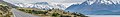
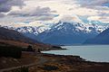
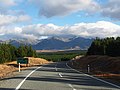
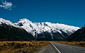
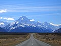
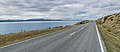
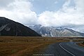
English: State Highway 80 is a New Zealand State Highway connecting State Highway 8 just north of Twizel with Mount Cook Village in the Aoraki/Mount Cook National Park. It runs north for 55 km, mostly along the western shore of Lake Pukaki. The road is a two-lane single carriageway, with several one-lane bridges closer to its dead end. (→New Zealand State Highway 80)
Media in category "State Highway 80 (New Zealand)"
The following 23 files are in this category, out of 23 total.
-
 Driving in NZ banner 1.jpg 2,841 × 406; 893 KB
-
 En route vers le Mount Cook National Park.jpg 3,278 × 2,185; 669 KB
-
 Lake Pukaki 10.jpg 2,988 × 1,453; 3.19 MB
-
 Lake pukaki and mt cook (8321347439).jpg 2,048 × 1,536; 4.17 MB
-
 Mount Cook from lower Tasman Valley - panoramio.jpg 2,451 × 1,534; 1.48 MB
-
 Mount Cook Road - 2013.04 - panoramio.jpg 4,608 × 3,456; 3.76 MB
-
 Mount Cook, New Zealand.jpg 5,184 × 3,456; 8.34 MB
-
 Mount Cook, NZ.jpg 3,921 × 2,353; 6.63 MB
-
 Mount Sefton. Mt Cook National Park. NZ (26267135705).jpg 4,000 × 2,213; 4.49 MB
-
 Mount Sefton. Mt Cook NP. NZ (32754540606).jpg 2,400 × 1,408; 2.59 MB
-
 Mt cook road New Zealand (Unsplash).jpg 4,711 × 2,961; 6.72 MB
-
 Mt Sefton. Mt Cook NP. NZ (22441711649).jpg 2,400 × 1,514; 2.97 MB
-
 Mt Sefton. New Zealand. (14382565847).jpg 2,400 × 1,800; 3.62 MB
-
 Road to mount cook new zealand.jpg 3,072 × 2,304; 4.43 MB
-
 Road to Mount Cook. NZ (15143746653).jpg 2,400 × 1,563; 3.18 MB
-
 Road to Mount Cook.NZ (13046770814).jpg 2,400 × 1,476; 3.65 MB
-
 Road towards Mount Cook (Unsplash).jpg 5,184 × 2,916; 7.99 MB
-
 SH80 in winter next to fog lifting over Lake Pukaki.jpg 4,896 × 3,264; 6.19 MB
-
 State Highway 80 and Lake Pukaki 01.jpg 2,841 × 1,581; 2.75 MB
-
 State Highway 80 and Lake Pukaki 02.jpg 2,989 × 1,284; 3.14 MB
-
 The Aroarokaehe Range. Mt Cook NP. NZ (32215055714).jpg 4,000 × 2,242; 6.68 MB
-
 View of Mount Cook Range 02.jpg 2,905 × 881; 1.72 MB
-
 通往隐士酒店的路 Hwy 80 - panoramio.jpg 2,200 × 1,467; 1.72 MB


.jpg)


.jpg)
.jpg)
.jpg)
.jpg)
.jpg)

.jpg)
.jpg)
.jpg)


.jpg)
