Category:Starston
Jump to navigation
Jump to search
English: Starston is a small village in Norfolk. It covers an area of and had a population of 321 in 123 households as of the 2001 census.
village in the United Kingdom  | |||||
| Upload media | |||||
| Instance of | |||||
|---|---|---|---|---|---|
| Location | South Norfolk, Norfolk, East of England, England | ||||
| Area |
| ||||
 | |||||
Subcategories
This category has the following 7 subcategories, out of 7 total.
B
E
- Environs of Starston (1 F)
M
S
- Starston village sign (5 F)
- Starston railway station (6 F)
- Starston windpump (4 F)
Media in category "Starston"
The following 181 files are in this category, out of 181 total.
-
 A muddy Green Lane, Starston - geograph.org.uk - 4339886.jpg 640 × 468; 113 KB
-

-

-
 Autumnal trees beside Clintergate Road - geograph.org.uk - 2149905.jpg 480 × 640; 198 KB
-
 Beck Hall - geograph.org.uk - 1593335.jpg 640 × 505; 175 KB
-

-
 Bleach Farm, Hardwick - geograph.org.uk - 4339880.jpg 640 × 480; 223 KB
-
 Bunn's Lane footpath to Railway Hill ^ Grove Road - geograph.org.uk - 4186538.jpg 2,206 × 2,944; 1.53 MB
-
 Chicken at Starston - geograph.org.uk - 2058151.jpg 800 × 531; 194 KB
-
 Church Hill - geograph.org.uk - 4798200.jpg 1,024 × 768; 258 KB
-
 Church Hill, Starston - geograph.org.uk - 4186457.jpg 2,965 × 2,227; 2.29 MB
-
 Cottage by Oaks Farm - geograph.org.uk - 2149677.jpg 640 × 480; 122 KB
-
 Cottages on The Street - geograph.org.uk - 1593341.jpg 640 × 452; 149 KB
-
 Cottages on The Street - geograph.org.uk - 1593344.jpg 640 × 564; 169 KB
-
 Cottages on The Street - geograph.org.uk - 1593346.jpg 640 × 555; 185 KB
-
 Cross Road sign - geograph.org.uk - 4388863.jpg 3,007 × 2,253; 5.29 MB
-
 Cross Road ^ Crossroads Victorian Postbox - geograph.org.uk - 4388858.jpg 3,072 × 2,304; 1.87 MB
-
 Cross Road, Starston - geograph.org.uk - 4388797.jpg 3,072 × 2,304; 3.08 MB
-
 Cross Road, Starston - geograph.org.uk - 4388870.jpg 3,072 × 2,304; 2.86 MB
-
 Crossroads Victorian Postbox - geograph.org.uk - 4388859.jpg 3,072 × 2,304; 5.31 MB
-
 Crossroads Victorian Postbox - geograph.org.uk - 4388860.jpg 2,304 × 3,072; 3.88 MB
-
 Crossroads Victorian Postbox - geograph.org.uk - 4388874.jpg 2,304 × 3,072; 4.06 MB
-
 Cultivated fields west of Starston - geograph.org.uk - 1593365.jpg 640 × 480; 148 KB
-
 Eggs for sale on Hardwick Road - geograph.org.uk - 4339881.jpg 640 × 480; 110 KB
-
 Entering Harleston on Rushall Road - geograph.org.uk - 4388753.jpg 3,072 × 2,304; 1.89 MB
-
 Entering Harleston on The Street - geograph.org.uk - 4186529.jpg 3,030 × 2,276; 1.55 MB
-
 Entering Sparston on Pulham Road - geograph.org.uk - 4260104.jpg 2,983 × 2,241; 2.32 MB
-
 Entering Starston - geograph.org.uk - 4798208.jpg 768 × 1,024; 225 KB
-
 Entrance to Beck Hall - geograph.org.uk - 1593334.jpg 640 × 485; 184 KB
-
 Entrance to Coniferhill, Starston - geograph.org.uk - 2185799.jpg 640 × 480; 131 KB
-
 Entrance to Starston Hall - geograph.org.uk - 2185770.jpg 640 × 480; 86 KB
-
 Entrance to Walnut Tree Cottage - geograph.org.uk - 4402651.jpg 3,072 × 2,304; 1.87 MB
-
 Evidence of the railway - geograph.org.uk - 1226431.jpg 480 × 640; 104 KB
-
 Field entrance ^ footpath off Low Road - geograph.org.uk - 4402521.jpg 3,072 × 2,304; 1.83 MB
-
 Footpath marker in hedge - geograph.org.uk - 1593372.jpg 640 × 480; 188 KB
-
 Footpath to the Beck - geograph.org.uk - 1593234.jpg 640 × 445; 160 KB
-
 Footpath west of Starston - geograph.org.uk - 1593370.jpg 640 × 450; 119 KB
-

-
 Gate into pasture north of Bleach Farm - geograph.org.uk - 2149657.jpg 640 × 480; 192 KB
-
 Green Lane sign - geograph.org.uk - 4402648.jpg 3,072 × 2,304; 1.95 MB
-
 Green Lane, Redenhall - geograph.org.uk - 4339921.jpg 640 × 480; 218 KB
-
 Green Lane, Starston - geograph.org.uk - 4402650.jpg 3,072 × 2,304; 1.93 MB
-
 Green Lane, Starston - geograph.org.uk - 4402652.jpg 3,072 × 2,200; 1.72 MB
-
 Hall Cottages, Starston - geograph.org.uk - 2185764.jpg 640 × 480; 78 KB
-
 Hallwong Lane, Harleston - geograph.org.uk - 4401846.jpg 3,072 × 2,304; 1.72 MB
-
 Hallwong Lane, Harleston - geograph.org.uk - 4402396.jpg 3,072 × 2,304; 1.81 MB
-
 Hardwick Road - geograph.org.uk - 4798386.jpg 1,024 × 768; 247 KB
-
 Hardwick Road past Bleach Farm - geograph.org.uk - 2149662.jpg 480 × 640; 145 KB
-
 Hardwick Road, Hardwick - geograph.org.uk - 4186419.jpg 3,072 × 2,304; 1.82 MB
-
 Hardwick Road, North Green - geograph.org.uk - 4186435.jpg 2,872 × 2,157; 1.08 MB
-
 Hardwick Road, North Green - geograph.org.uk - 4186439.jpg 2,948 × 2,214; 1.56 MB
-
 Hardwick Road, North Green - geograph.org.uk - 4186440.jpg 3,072 × 2,304; 1.77 MB
-
 Hardwick Road, North Green - geograph.org.uk - 4402659.jpg 3,072 × 2,304; 1.92 MB
-
 Hardwick Road, North Green - geograph.org.uk - 4404000.jpg 3,072 × 2,304; 1.67 MB
-
 Hardwick Road, Starston - geograph.org.uk - 4186445.jpg 3,072 × 2,246; 1.19 MB
-
 Harleston Village Name sign on Rushall Road - geograph.org.uk - 4388758.jpg 2,304 × 3,072; 2.92 MB
-
 Heading west on Lonely Road - geograph.org.uk - 2149685.jpg 640 × 480; 138 KB
-

-
 House at the end of a track - geograph.org.uk - 1592880.jpg 640 × 471; 129 KB
-

-
 Lonely Lane, North Green - geograph.org.uk - 4186438.jpg 3,072 × 2,304; 1.85 MB
-
 Low Road sign - geograph.org.uk - 4402422.jpg 3,072 × 2,304; 2.02 MB
-
 Low Road ^ entrances - geograph.org.uk - 4402478.jpg 3,072 × 2,227; 2.67 MB
-
 Low Road, Starston - geograph.org.uk - 4186512.jpg 3,072 × 2,304; 1.86 MB
-
 Low Road, Starston - geograph.org.uk - 4402404.jpg 3,072 × 2,304; 1.84 MB
-
 Low Road, Starston - geograph.org.uk - 4402415.jpg 3,072 × 2,304; 1.92 MB
-
 Low Road, Starston - geograph.org.uk - 4402530.jpg 3,072 × 2,304; 1.95 MB
-

-

-
 Mull's Loke - geograph.org.uk - 4798379.jpg 1,024 × 768; 290 KB
-
 Mull's Loke footpath - geograph.org.uk - 4402660.jpg 3,072 × 2,304; 2.11 MB
-
 Mull's Loke footpath - geograph.org.uk - 4403946.jpg 2,304 × 3,072; 2.51 MB
-
 Narrow path skirting a field's edge - geograph.org.uk - 1593367.jpg 640 × 448; 136 KB
-
 Oaks Farm - geograph.org.uk - 2149671.jpg 640 × 480; 177 KB
-
 One of many on Mull's Loke - geograph.org.uk - 562728.jpg 521 × 640; 153 KB
-
 Open country - geograph.org.uk - 4339901.jpg 640 × 480; 111 KB
-
 Parish Church of St Margaret - geograph.org.uk - 5702777.jpg 2,104 × 1,184; 258 KB
-
 Path along the Beck - geograph.org.uk - 1593236.jpg 640 × 450; 144 KB
-
 Pond and Wood Farm, Starston - geograph.org.uk - 4339885.jpg 640 × 480; 246 KB
-
 Private 'road' to Gawdy Hall - geograph.org.uk - 4339918.jpg 640 × 480; 177 KB
-
 Pulham Road sign - geograph.org.uk - 4260112.jpg 3,011 × 2,262; 2.73 MB
-
 Railway Hill, Starston - geograph.org.uk - 4186533.jpg 2,316 × 2,305; 1.63 MB
-
 River ^ Bridge - geograph.org.uk - 4402429.jpg 3,072 × 2,304; 1.97 MB
-
 Road Junction - geograph.org.uk - 4798424.jpg 1,024 × 768; 172 KB
-
 Road junction near Gillows Willows Farm - geograph.org.uk - 4339874.jpg 640 × 480; 176 KB
-
 Roadsign off Hardwick Road - geograph.org.uk - 4403957.jpg 2,304 × 3,072; 2.43 MB
-
 Roadsign on Hallwong Lane - geograph.org.uk - 4401852.jpg 2,253 × 2,995; 2.42 MB
-
 Roadsign on Upper Harman's Lane - geograph.org.uk - 4388881.jpg 2,216 × 2,947; 4.54 MB
-
 Roadsign ^ Cross Road sign - geograph.org.uk - 4388867.jpg 2,216 × 2,947; 4.45 MB
-
 Roadsign ^ Cross Road sign - geograph.org.uk - 4388875.jpg 2,253 × 2,995; 1.83 MB
-
 Rouse's Lane, Starston - geograph.org.uk - 4402518.jpg 2,304 × 2,484; 1.73 MB
-
 Rouse's Lane, Starston - geograph.org.uk - 4402535.jpg 3,072 × 2,304; 1.79 MB
-
 Rushall Road - geograph.org.uk - 4388774.jpg 3,072 × 2,304; 1.83 MB
-
 Rushall Road near Crane's Watering Farm - geograph.org.uk - 4339869.jpg 640 × 480; 131 KB
-
 Rushall Road sign - geograph.org.uk - 4388750.jpg 3,007 × 2,253; 4.06 MB
-
 Rushall Road, Harleston - geograph.org.uk - 4388747.jpg 3,072 × 2,277; 3.5 MB
-
 Rushall Road, Harleston - geograph.org.uk - 4388761.jpg 3,072 × 2,304; 3.64 MB
-
 Rushall Road, Starston - geograph.org.uk - 4388795.jpg 3,072 × 2,304; 1.88 MB
-
 Rushall Road, Starston - geograph.org.uk - 4388872.jpg 3,072 × 2,304; 1.82 MB
-
 Rushall Road, Starston - geograph.org.uk - 4388873.jpg 3,072 × 2,304; 1.75 MB
-
 Rushall Road, Starston - geograph.org.uk - 4388877.jpg 3,072 × 2,304; 1.96 MB
-
 Rushall Road, Starston - geograph.org.uk - 4388882.jpg 3,072 × 2,304; 1.72 MB
-
 Skinner's Lane - geograph.org.uk - 4798447.jpg 1,024 × 768; 306 KB
-
 Skinner's Lane, Starston - geograph.org.uk - 2185761.jpg 640 × 480; 85 KB
-
 Skinner's Lane, Starston - geograph.org.uk - 4186447.jpg 3,072 × 2,304; 2.06 MB
-
 Sparston Village Name sign on Pulham Road - geograph.org.uk - 4260107.jpg 2,885 × 2,173; 3.08 MB
-
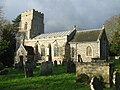 St Margaret Starston - geograph.org.uk - 4798183.jpg 1,024 × 768; 237 KB
-
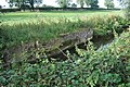 Starston Beck - geograph.org.uk - 2058170.jpg 800 × 531; 186 KB
-
 Starston Bridge on The Street - geograph.org.uk - 4402455.jpg 3,072 × 2,304; 1.98 MB
-
 Starston Hollow Windpump - geograph.org.uk - 2058125.jpg 800 × 524; 114 KB
-
 Starston Jubilee Hall - geograph.org.uk - 1593317.jpg 640 × 447; 121 KB
-
 Starston Jubilee Hall - geograph.org.uk - 1593318.jpg 640 × 457; 148 KB
-
 Starston Jubilee Hall - geograph.org.uk - 4186514.jpg 2,961 × 2,229; 1.61 MB
-
 Starston the Village - geograph.org.uk - 1226398.jpg 640 × 480; 52 KB
-
 Starston village sign (detail) - geograph.org.uk - 4432420.jpg 2,600 × 3,467; 2.5 MB
-
 Starston Village sign - geograph.org.uk - 2185780.jpg 640 × 480; 129 KB
-
 Starston Village sign - geograph.org.uk - 4186504.jpg 2,233 × 2,980; 1.97 MB
-
 Starston Village sign - geograph.org.uk - 4186506.jpg 2,270 × 3,030; 1.48 MB
-
 Starston Village sign on The Street - geograph.org.uk - 4260305.jpg 2,304 × 3,072; 1.86 MB
-
 Starston War Memorials - geograph.org.uk - 4516479.jpg 3,456 × 2,592; 3.71 MB
-
 Starston Wind Pump - geograph.org.uk - 5294530.jpg 1,003 × 633; 115 KB
-
 Starston Windpump - geograph.org.uk - 2058135.jpg 800 × 531; 118 KB
-
 Starston Windpump - geograph.org.uk - 2058140.jpg 800 × 531; 139 KB
-
 Starston Windpump - geograph.org.uk - 2058155.jpg 800 × 531; 63 KB
-
 Starston, St Margaret - geograph.org.uk - 4423935.jpg 3,264 × 2,448; 1.62 MB
-

-
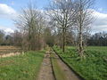 The dismantled Waveney railway - geograph.org.uk - 1226413.jpg 640 × 480; 108 KB
-

-

-
 The Street - geograph.org.uk - 4798219.jpg 768 × 1,024; 253 KB
-
 The Street Postbox - geograph.org.uk - 4260347.jpg 2,215 × 2,956; 3.16 MB
-
 The Street Postbox - geograph.org.uk - 4260349.jpg 2,304 × 3,072; 1.89 MB
-
 The Street Postbox ^ Starston Village Map - geograph.org.uk - 4260348.jpg 2,760 × 2,168; 2.45 MB
-
 The Street sign - geograph.org.uk - 4186467.jpg 3,072 × 2,304; 1.67 MB
-
 The Street ^ Starston Village sign - geograph.org.uk - 4260337.jpg 3,072 × 2,304; 2.07 MB
-
 The Street ^ Starston Village sign - geograph.org.uk - 4260391.jpg 3,029 × 2,276; 2.95 MB
-
 The Street, Starston - geograph.org.uk - 4186461.jpg 3,072 × 2,304; 1.98 MB
-
 The Street, Starston - geograph.org.uk - 4186462.jpg 3,072 × 2,105; 1.88 MB
-
 The Street, Starston - geograph.org.uk - 4260321.jpg 2,948 × 2,214; 2.79 MB
-
 The Street, Starston - geograph.org.uk - 4260489.jpg 2,776 × 2,086; 2.42 MB
-
 The Street, Starston - geograph.org.uk - 4339839.jpg 640 × 480; 147 KB
-
 The view down Church Hill, Starston - geograph.org.uk - 4577088.jpg 1,152 × 2,048; 1.59 MB
-
 This road used to lead to Redenhall - geograph.org.uk - 2185792.jpg 640 × 480; 135 KB
-
 To Hardwick Road on Lonely Road - geograph.org.uk - 2150460.jpg 640 × 480; 112 KB
-
 Track to Clintergate - geograph.org.uk - 4339892.jpg 640 × 480; 221 KB
-
 Track to Oaklands Farm - geograph.org.uk - 4339888.jpg 640 × 480; 134 KB
-
 Traditional wind turbine - geograph.org.uk - 1226441.jpg 640 × 480; 51 KB
-
 Transformer supplying Willow Farm - geograph.org.uk - 2149898.jpg 640 × 480; 107 KB
-
-

-
 Upper Harman's Lane sign - geograph.org.uk - 4388880.jpg 3,033 × 2,272; 4.42 MB
-
 Upper Harmans Lane - geograph.org.uk - 2033381.jpg 640 × 480; 72 KB
-
 Victorian Postbox at Cross Road - geograph.org.uk - 4339851.jpg 640 × 480; 157 KB
-
 Victorian Postbox at Cross Road - geograph.org.uk - 4339853.jpg 480 × 640; 215 KB
-
 View across the Beck - geograph.org.uk - 1593374.jpg 480 × 640; 148 KB
-
 View across the Beck - geograph.org.uk - 1593379.jpg 640 × 480; 177 KB
-
 View along Hardwick Road - geograph.org.uk - 2149592.jpg 640 × 480; 169 KB
-
 View along the Beck - geograph.org.uk - 1593375.jpg 640 × 454; 144 KB
-
 View east along Clintergate Road - geograph.org.uk - 2149904.jpg 640 × 480; 153 KB
-
 View north up Church Hill - geograph.org.uk - 1593248.jpg 480 × 640; 171 KB
-

-
 View south up Railway Hill - geograph.org.uk - 1593339.jpg 640 × 480; 142 KB
-
 View west along the Beck - geograph.org.uk - 1593243.jpg 640 × 480; 187 KB
-
 View west along The Street in Starston - geograph.org.uk - 1593320.jpg 640 × 457; 150 KB
-
 Village sign at Starston - geograph.org.uk - 4432415.jpg 1,024 × 768; 664 KB
-
 Walnut Tree Cottage sign - geograph.org.uk - 4402649.jpg 2,159 × 2,871; 4.01 MB
-

-
 Weeping Willow near Wood Farm - geograph.org.uk - 4339905.jpg 640 × 480; 194 KB
-
 Wet leaves littering pavement - geograph.org.uk - 1593324.jpg 640 × 514; 151 KB
-
 White-out at Starston - geograph.org.uk - 2185754.jpg 700 × 525; 129 KB
-
 Willows growing by the Beck - geograph.org.uk - 1593378.jpg 480 × 640; 167 KB
-
 Wind Turbine at White House Farm - geograph.org.uk - 4388890.jpg 3,072 × 2,304; 1.95 MB
-
 Wind Turbine at White House Farm - geograph.org.uk - 4388891.jpg 2,170 × 2,885; 1.78 MB
-
 Wood Lane sign - geograph.org.uk - 4402657.jpg 3,007 × 2,253; 6.07 MB
-
 Wood Lane sign - geograph.org.uk - 4403939.jpg 3,072 × 2,304; 3.36 MB
-
 Wood Lane, North Green - geograph.org.uk - 4186441.jpg 3,072 × 2,304; 1.8 MB
-
 Wood Lane, North Green - geograph.org.uk - 4402654.jpg 3,072 × 2,304; 1.9 MB
-
 Wood Lane, North Green - geograph.org.uk - 4402658.jpg 3,072 × 2,304; 1.87 MB
-
 Wood Lane, North Green - geograph.org.uk - 4403966.jpg 3,072 × 2,304; 1.83 MB
-
 Wood Lane, Starston - geograph.org.uk - 4403985.jpg 3,072 × 2,304; 1.79 MB
-
 Looking towards White House Farm Lane - geograph.org.uk - 351511.jpg 640 × 480; 86 KB


_-_geograph.org.uk_-_4432420.jpg)


