Category:Stadtkirche Büren an der Aare
Jump to navigation
Jump to search
| Object location | | View all coordinates using: OpenStreetMap |
|---|
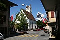
church building in Büren an der Aare in the canton of Bern, Switzerland  | |||||
| Upload media | |||||
| Instance of | |||||
|---|---|---|---|---|---|
| Part of | |||||
| Location | Büren an der Aare, Seeland administrative district, Seeland administrative region, Bern, Switzerland | ||||
| Street address |
| ||||
| Heritage designation | |||||
| Inception |
| ||||
 | |||||
Media in category "Stadtkirche Büren an der Aare"
The following 6 files are in this category, out of 6 total.
-
 Bueren ref Kirche.jpg 3,456 × 2,304; 1.37 MB
-
 Bueren-a-A-Laendti.jpg 800 × 1,200; 832 KB
-
 Bueren-a-A-Stadtkirche.jpg 800 × 1,200; 760 KB
-
 CH-NB - Büren an der Aare - Collection Gugelmann - GS-GUGE-WEIBEL-D-24a.tif 5,700 × 3,745, 2 pages; 33.57 MB
-
 CH-NB - Büren an der Aare - Collection Gugelmann - GS-GUGE-WEIBEL-D-24b.tif 5,700 × 3,770, 2 pages; 43.15 MB
-
 Swiss buren 02.JPG 2,048 × 1,536; 619 KB


