Category:Stadswaag (Buren)
Jump to navigation
Jump to search
| Object location | | View all coordinates using: OpenStreetMap |
|---|
.jpg) | |||||
| Upload media | |||||
| Instance of | |||||
|---|---|---|---|---|---|
| Location | Buren, Gelderland, Netherlands | ||||
| Street address |
| ||||
| Heritage designation |
| ||||
 | |||||
Nederlands: Stadswaag, Buren
|
This is a category about rijksmonument number 11331
|
| Address |
|
Media in category "Stadswaag (Buren)"
The following 6 files are in this category, out of 6 total.
-
 4116 Buren, Netherlands - panoramio (22).jpg 2,048 × 1,148; 489 KB
-
 4116 Buren, Netherlands - panoramio (46).jpg 2,048 × 1,148; 468 KB
-
 Buren RM Stadswaag (1).jpg 4,475 × 3,363; 5.96 MB
-
 Buren RM Stadswaag (2).jpg 3,218 × 4,456; 4.91 MB
-
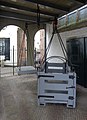
 Buren weigh scales.JPG 3,264 × 2,448; 3.22 MB
-
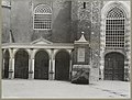 Waag tegen de kerk aan gebouwd - Buren - 20325781 - RCE.jpg 1,200 × 914; 217 KB
.jpg)
.jpg)
.jpg)

