Category:St Mary the Virgin's church, Woodnesborough
Jump to navigation
Jump to search
| Object location | | View all coordinates using: OpenStreetMap |
|---|
church in Woodnesborough, Kent, England, United Kingdom  | |||||
| Upload media | |||||
| Instance of | |||||
|---|---|---|---|---|---|
| Dedicated to | |||||
| Location | Woodnesborough, Dover, Kent, South East England, England | ||||
| Diocese | |||||
| Heritage designation |
| ||||
| Religion or worldview | |||||
 | |||||
Subcategories
This category has the following 2 subcategories, out of 2 total.
Media in category "St Mary the Virgin's church, Woodnesborough"
The following 13 files are in this category, out of 13 total.
-
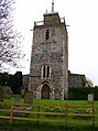
 Church of St Mary the Virgin, Woodnesborough, Kent - tower at west.jpg 2,000 × 3,000; 5.42 MB
-
 Church of St Mary the Virgin, Woodnesborough, Kent - churchyard path at west.jpg 2,000 × 3,000; 5.37 MB
-
 Church of St Mary the Virgin, Woodnesborough, Kent - north aisle northwest buttress.jpg 2,000 × 3,000; 5.05 MB
-
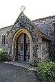 Church of St Mary the Virgin, Woodnesborough, Kent - north porch.jpg 2,000 × 3,000; 4.31 MB
-
 Church of St Mary the Virgin, Woodnesborough, Kent - north porch door.jpg 2,000 × 3,000; 5.19 MB
-
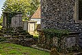 Church of St Mary the Virgin, Woodnesborough, Kent - churchyard table tombs.jpg 6,050 × 4,033; 28.12 MB
-
 Church of St Mary the Virgin, Woodnesborough, Kent - churchyard and chancel.jpg 2,250 × 3,000; 5.08 MB
-

-
 St Mary the Virgin, Woodnesborough, Kent - geograph.org.uk - 325997.jpg 480 × 640; 160 KB
-
 St Mary Woodnesborough 1.jpg 3,826 × 5,715; 7.74 MB
-
 St Mary's Church, Woodnesborough - geograph.org.uk - 219653.jpg 478 × 640; 100 KB
-
 Woodnesborough church - geograph.org.uk - 626607.jpg 640 × 480; 58 KB
-


