Category:St Mary's, East Compton, Dorset (ruined church)
Jump to navigation
Jump to search
This is a category about listed building number 1004551. |
This is a category about listed building number 1172395. |
| Object location | | View all coordinates using: OpenStreetMap |
|---|
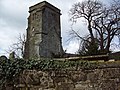
tower, formerly part of church in East Compton, Compton Abbas, Dorset, United Kingdom  | |||||
| Upload media | |||||
| Instance of | |||||
|---|---|---|---|---|---|
| Location | East Compton, Compton Abbas, Dorset, South West England, England | ||||
| Heritage designation | |||||
 | |||||
Media in category "St Mary's, East Compton, Dorset (ruined church)"
The following 7 files are in this category, out of 7 total.
-
 At the church gate, East Compton - geograph.org.uk - 369962.jpg 640 × 480; 147 KB
-
 Compton Abbas, the old church - geograph.org.uk - 503994.jpg 429 × 640; 85 KB
-

-
-

-
 St Mary's Church, Compton Abbas - geograph.org.uk - 4480632.jpg 480 × 640; 73 KB
-


