Category:St Faith's Church, Waterloo
Jump to navigation
Jump to search
| Object location | | View all coordinates using: OpenStreetMap |
|---|
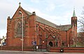
Grade II listed church in Sefton, Merseyside, L22  | |||||
| Upload media | |||||
| Instance of | |||||
|---|---|---|---|---|---|
| Dedicated to | |||||
| Location | Sefton, Merseyside, North West England, England | ||||
| Diocese | |||||
| Heritage designation |
| ||||
| Religion or worldview | |||||
| official website | |||||
 | |||||
Media in category "St Faith's Church, Waterloo"
The following 5 files are in this category, out of 5 total.
-
 North porch of St Faith's, Waterloo.jpg 4,862 × 3,358; 22.04 MB
-
 South porch of St Faith's, Waterloo.jpg 4,868 × 3,286; 21 MB
-
 St Faith's Church, Waterloo 1.jpg 4,837 × 3,122; 17.39 MB
-
 St Faith's Church, Waterloo 2.jpg 4,719 × 3,353; 15.73 MB
-
 St Faith's Church, Waterloo 3.jpg 4,320 × 2,771; 12.27 MB


