Category:St Cleer Holy Well
Jump to navigation
Jump to search
| Object location | | View all coordinates using: OpenStreetMap |
|---|
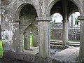
Grade I listed structure in St Cleer, Cornwall, United Kingdom  | |||||
| Upload media | |||||
| Instance of | |||||
|---|---|---|---|---|---|
| Part of |
| ||||
| Location | St Cleer, Cornwall, South West England, England | ||||
| Heritage designation |
| ||||
 | |||||
Media in category "St Cleer Holy Well"
The following 6 files are in this category, out of 6 total.
-
 Close up of The Holy Well at St. Cleer, Cornwall (geograph 2099977).jpg 640 × 480; 102 KB
-
 Holy Well at St Cleer - geograph.org.uk - 93815.jpg 591 × 388; 127 KB
-
 Saint Cleer's (Clare) well, Liskeard, Cornwall. Wellcome M0002532.jpg 1,832 × 1,465; 943 KB
-
 St Cleer Holy Well - geograph.org.uk - 361931.jpg 640 × 452; 156 KB
-
 St Cleer holy well.jpg 3,040 × 2,288; 2.89 MB
-
 The Holy Well of St. Cleer, Cornwall (geograph 2099966).jpg 640 × 480; 106 KB
.jpg)

_well,_Liskeard,_Cornwall._Wellcome_M0002532.jpg)

.jpg)