Category:St Benet's Chapel, Netherton
Jump to navigation
Jump to search
| Object location | | View all coordinates using: OpenStreetMap |
|---|
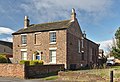
former church in the United Kingdom  | |||||
| Upload media | |||||
| Instance of | |||||
|---|---|---|---|---|---|
| Location | Sefton, Merseyside, North West England, England | ||||
| Heritage designation |
| ||||
| Inception |
| ||||
| Date of official closure |
| ||||
| official website | |||||
 | |||||
Media in category "St Benet's Chapel, Netherton"
The following 3 files are in this category, out of 3 total.
-
 St Benet's Chapel, Netherton 1.jpg 4,191 × 3,232; 19.4 MB
-
 St Benet's Chapel, Netherton 2.jpg 4,448 × 3,033; 18.5 MB
-
 St Benet's Chapel, Netherton.jpg 1,944 × 1,776; 919 KB

