Category:St. Theodul (Sachseln)
Jump to navigation
Jump to search
| Object location | | View all coordinates using: OpenStreetMap |
|---|
church building in Sachslen in the canton of Obwalden, Switzerland   | |||||
| Upload media | |||||
| Instance of | |||||
|---|---|---|---|---|---|
| Part of | |||||
| Location | Sachseln, Obwalden, Switzerland | ||||
| Street address |
| ||||
| Architectural style | |||||
| Diocese | |||||
| Heritage designation | |||||
 | |||||
Media in category "St. Theodul (Sachseln)"
The following 68 files are in this category, out of 68 total.
-
 2014-Sachseln-Dorothee.jpg 1,500 × 1,500; 2.06 MB
-
 600 Jahre Bruder Klaus in Sachseln.jpg 3,346 × 5,021; 2.99 MB
-
 Betrachtungsbild mit Beschreibung.jpg 3,178 × 4,608; 2.42 MB
-
 ETH-BIB-Sachseln Kirche, Klaus-Altar und Kanzel-Dia 247-13745.tif 3,098 × 3,470; 10.32 MB
-
 ETH-BIB-Sachseln, Kirche Gibel von Norden-Dia 247-13746.tif 2,936 × 3,458; 9.76 MB
-
 ETH-BIB-Sachseln, Kirche von oben (Südost)-Dia 247-13747.tif 2,997 × 3,464; 9.99 MB
-
 Grabstätte Web.jpg 763 × 600; 85 KB
-
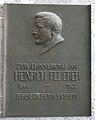 HeinrichFederer Gedenktafel Ehrenbürger Sachseln.jpg 571 × 723; 80 KB
-
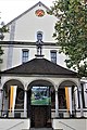
 Katholische Pfarr- und Wallfahrtskirche St. Theodul.jpg 2,448 × 3,264; 6.99 MB
-
 Kirche Sachseln Altar.jpg 1,024 × 557; 124 KB
-
 Kirche Sachseln Altarraum.jpg 1,024 × 711; 181 KB
-
 Kirche Sachseln Barbara.jpg 497 × 1,024; 95 KB
-
 Kirche Sachseln Benedikt.jpg 498 × 1,024; 96 KB
-
 Kirche Sachseln Betrachtungsbild.jpg 968 × 1,024; 179 KB
-
 Kirche Sachseln Dominik.jpg 498 × 1,024; 94 KB
-
 Kirche Sachseln Empore.jpg 1,024 × 715; 185 KB
-
 Kirche Sachseln Eremitenrock.jpg 468 × 1,024; 84 KB
-
 Kirche Sachseln Frontfassade.jpg 780 × 1,024; 206 KB
-
 Kirche Sachseln Gemälde Rückwand.jpg 781 × 1,024; 104 KB
-
 Kirche Sachseln Johannes Evangelist.jpg 498 × 1,024; 100 KB
-
 Kirche Sachseln Johannes Täufer.jpg 498 × 1,024; 98 KB
-
 Kirche Sachseln Josef.jpg 498 × 1,024; 95 KB
-
 Kirche Sachseln Katharina.jpg 498 × 1,024; 106 KB
-
 Kirche Sachseln Linke Seitenaltäre.jpg 1,024 × 683; 186 KB
-
 Kirche Sachseln mit Friedhof.jpg 3,059 × 2,146; 1.15 MB
-
 Kirche Sachseln Mosaik links.jpg 1,024 × 975; 243 KB
-
 Kirche Sachseln Mosaik rechts.jpg 2,392 × 2,512; 1.09 MB
-
 Kirche Sachseln Orgel.jpg 1,024 × 583; 128 KB
-
 Kirche Sachseln Petrus.jpg 497 × 1,024; 108 KB
-
 Kirche Sachseln Pieta.jpg 2,192 × 2,784; 919 KB
-
 Kirche Sachseln Rechte Seitenaltäre.jpg 3,196 × 2,359; 1.25 MB
-
 Kirche Sachseln Taufbecken.jpg 1,955 × 3,311; 884 KB
-
 Kirche Sachseln Turm.jpg 495 × 1,024; 111 KB
-
 Kirche Sachseln Wappentafel.jpg 1,911 × 2,172; 658 KB
-
 Kirche Sachseln.jpg 1,024 × 825; 186 KB
-
 Meyers Universum Band 15 35.jpg 3,830 × 2,942; 5.66 MB
-
 Nicholas-Flue.jpg 250 × 390; 48 KB
-
 Pfarr- und Wallfahrtskirche Sachseln innen Blockalter.jpg 2,584 × 3,586; 5.47 MB
-
 Pfarr- und Wallfahrtskirche Sachseln innen.jpg 2,587 × 3,106; 4.86 MB
-

-
 Pfarr- und Wallfahrtskirche Sachseln, Empore.jpg 1,024 × 670; 139 KB
-
 Pfarr- und Wallfahrtskirche Sachseln, Portal.jpg 683 × 1,024; 204 KB
-
 Pfarr- und Wallfahrtskirche St. Thedul, Sachseln.jpg 3,000 × 4,000; 7.46 MB
-
 Pfarr- und Wallfahrtskirche St. Theodul in Sachseln OW.jpg 3,246 × 3,600; 7.1 MB
-
 Picswiss OW-26-38.jpg 300 × 450; 43 KB
-
 Picswiss OW-26-45.jpg 300 × 450; 43 KB
-
 Picswiss OW-26-46.jpg 500 × 333; 61 KB
-
 Picswiss OW-26-47.jpg 296 × 450; 40 KB
-
 Sachseln OW Eglise 2.jpg 1,536 × 2,048; 1.46 MB
-
 Sachseln OW Eglise 6, robe de bure de Nicolas de Flüe.jpg 1,536 × 2,048; 616 KB
-
 Sachseln OW Kirche 3.jpg 1,536 × 2,048; 1.43 MB
-
 Sachseln OW Kirche 4 linteau de porte daté 1778.jpg 2,048 × 1,536; 1.13 MB
-
 Sachseln OW Kirche 5 ferrures de porte, 1778.jpg 1,536 × 2,048; 1.07 MB
-
 Sachseln-am-Sarnersee.jpg 800 × 533; 120 KB
-
 Sachseln-Pfarrkirche.jpg 1,800 × 1,210; 1.8 MB
-
 Sachseln. Dettaglio del portale ligneo con iscrizione della chiesa di Sankt Theodul.jpg 3,000 × 2,033; 886 KB
-
 Sachseln. Dettaglio del soffitto e dell'altare della chiesa di Sankt Theodul.jpg 3,000 × 2,067; 533 KB
-
 Sachseln. Interno della chiesa di Sankt Theodul (DOI 24984).jpg 1,998 × 3,000; 276 KB
-
 Sachseln. Interno della chiesa di Sankt Theodul.jpg 3,000 × 2,075; 377 KB
-
 Sachseln. Navata centrale e altare della chiesa di Sankt Theodul.jpg 1,986 × 3,000; 425 KB
-
 Sachseln. Portale ligneo della chiesa di Sankt Theodul.jpg 2,050 × 3,000; 734 KB
-
 Sachseln. Retro della porta della chiesa di Sankt Theodul.jpg 2,052 × 3,000; 502 KB
-
 Sachseln. Veduta della chiesa di Sankt Theodul (DOI 24979).jpg 2,051 × 3,000; 834 KB
-
 Sachseln. Veduta della chiesa di Sankt Theodul (DOI 24986).jpg 2,063 × 3,000; 979 KB
-
 Sachseln. Veduta della chiesa di Sankt Theodul.jpg 2,068 × 3,000; 779 KB
-
 The sepulchre of Nicholas von der Flueh, Sachseln, Unterwald, Switzerland-LCCN2001703265.jpg 2,755 × 3,674; 3.19 MB
-
 Wallfahrtskerzen vor Pietâ in Sachseln OW, Schweiz.jpg 2,667 × 4,000; 7.04 MB
-
 Meyer’s Universum Bd. 15. 1852 (140313068).jpg 4,675 × 3,376; 19.31 MB


.jpg)


.jpg)
.jpg)


.jpg)