Category:St. Leonarduskerk, Oosterhout
Jump to navigation
Jump to search
| Object location | | View all coordinates using: OpenStreetMap |
|---|
church in Oosterhout (Gld), Netherlands  | |||||
| Upload media | |||||
| Instance of | |||||
|---|---|---|---|---|---|
| Part of |
| ||||
| Location | Oosterhout, Overbetuwe, Gelderland, Netherlands | ||||
| Street address |
| ||||
| Located on street |
| ||||
| Heritage designation |
| ||||
| Religion or worldview | |||||
 | |||||
|
This is a category about rijksmonumentcomplex number 523905
|
Kerk
|
This is a category about rijksmonument number 523906
|
Pastorie
|
This is a category about rijksmonument number 523907
|
Kruisbeeld
|
This is a category about rijksmonument number 523908
|
| Address |
|
Subcategories
This category has the following 2 subcategories, out of 2 total.
Media in category "St. Leonarduskerk, Oosterhout"
The following 7 files are in this category, out of 7 total.
-
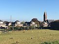 Oosterhout gem. Overbetuwe vanaf dijk.jpg 3,264 × 2,448; 1.31 MB
-
 Oosterhout kerk RM 523906 en pastorie RM 523907 achterkant.JPG 3,648 × 2,736; 4.23 MB
-
 Oosterhout kerk RM 523906 en pastorie RM 523907 voorkant.JPG 3,648 × 2,736; 3.77 MB
-
 Oosterhout Rijksmonument 523906 kerk absis.JPG 2,736 × 3,648; 3.6 MB
-
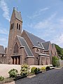 Oosterhout Rijksmonument 523906 kerk.JPG 2,736 × 3,648; 3.46 MB
-
 Oosterhout, de Sint-Leonarduskerk RM523906 IMG 4127 2020-04-05 18.35.jpg 3,553 × 5,330; 11.12 MB
-
 Oosterhout, kerk foto1 2011-05-02 11.46.jpg 4,416 × 3,312; 7.64 MB


