Category:St. Josef (Schmitten)
Jump to navigation
Jump to search
| Object location | | View all coordinates using: OpenStreetMap |
|---|
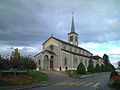
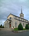
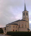
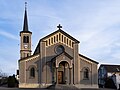
church building in Schmitten in the canton of Fribourg, Switzerland  | |||||
| Upload media | |||||
| Instance of | |||||
|---|---|---|---|---|---|
| Part of | |||||
| Location | Schmitten, Sense District, Canton of Fribourg, Switzerland | ||||
| Street address |
| ||||
| Diocese | |||||
| Architect | |||||
| Heritage designation | |||||
| Inception |
| ||||
 | |||||
Media in category "St. Josef (Schmitten)"
The following 11 files are in this category, out of 11 total.
-
 2001-09-16 Pfarrkirche Sankt Joseph Schmitten FR 05.JPG 2,400 × 1,800; 628 KB
-
 Pfarrkirche Schmitten.jpg 4,608 × 3,072; 4.57 MB
-
 PfarrkircheKreuzauffindung.jpg 2,904 × 2,439; 458 KB
-
 2001-09-16 Pfarrkirche Sankt Joseph Schmitten FR 06.jpg 1,800 × 2,280; 953 KB
-
 Schmittenaurore modifié-1.jpg 2,544 × 2,905; 611 KB
-
 Schmittenaurore.jpg 2,544 × 2,905; 601 KB
-
 Schmitteneglise1.jpg 2,904 × 2,439; 453 KB
-
 Schmittenrose.JPG 2,604 × 3,472; 3 MB
-
 Schmittenroseblanche.jpg 2,604 × 3,472; 1.06 MB
-
 Église Saint-Joseph de Schmitten - Vue de l'ouest.jpg 8,629 × 6,472; 24.18 MB
-
 Église Saint-Joseph de Schmitten - Vue du sud-ouest.jpg 12,049 × 6,778; 34.45 MB


