Category:St. Jakob (Munich)
Jump to navigation
Jump to search
| Object location | | View all coordinates using: OpenStreetMap |
|---|
This is the category of the Bavarian Baudenkmal (cultural heritage monument) with the ID D-1-62-000-7887 (Wikidata)
|
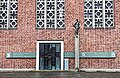
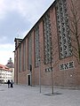
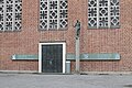
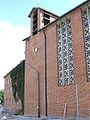
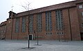
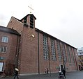
Deutsch: Katholische Kloster- und Institutskirche St. Jakob am Anger, Unterer Anger/St.-Jakobs-Platz, München. Schlichter Sichtziegelbau, 1955–1956 von Friedrich Haindl; lichter, hallenartiger Innenraum mit freskierter Flachdecke, dreiseitiger Empore und zweigeschossigem Oratorium; mit Ausstattung.
church   | |||||
| Upload media | |||||
| Instance of | |||||
|---|---|---|---|---|---|
| Named after | |||||
| Made from material | |||||
| Location | Altstadt (Munich), Munich, Upper Bavaria, Bavaria, Germany | ||||
| Street address |
| ||||
| Located on street | |||||
| Has part(s) |
| ||||
| Heritage designation | |||||
| Inception |
| ||||
| Date of official opening |
| ||||
 | |||||
English: The Catholic Monastery and Institute Church St. Jakob am Anger, Lower Anger / St. Jakobs Platz, Munich. The simple red brick building, 1955-1956 by Friedrich Haindl; has a hall-like interior with a frescoed flat ceiling, three-sided gallery and two-story oratory.
Subcategories
This category has the following 3 subcategories, out of 3 total.
Media in category "St. Jakob (Munich)"
The following 23 files are in this category, out of 23 total.
-
 Eingang in Kirche und Kloster St. Jakob am Anger.jpg 5,100 × 3,310; 18.54 MB
-
 Gemeinde von St. Lukas vor St. Jakob am Anger.jpg 5,100 × 2,731; 12.23 MB
-
 Kloster und Gymnasium von St. Jakob in München.jpg 5,100 × 2,966; 14.38 MB
-
 München (9591742211).jpg 3,456 × 4,608; 3.09 MB
-
 München - St. Jakob.JPG 2,816 × 2,112; 2.23 MB
-
 St Jakob am Anger Denkmal Gerhardinger.jpg 2,448 × 3,264; 2.46 MB
-
 St Jakob am Anger Grabmal Gerhardinger detail.jpg 3,264 × 2,448; 2.86 MB
-
 St Jakob am Anger.jpg 2,448 × 3,264; 2.37 MB
-
 St. Jakob 19-05-20 451.jpg 4,608 × 3,072; 4.57 MB
-
 St. Jakob 19-05-20 452.jpg 4,608 × 3,072; 4.11 MB
-
 St. Jakob Muenchen-1.jpg 900 × 1,200; 460 KB
-
 St. Jakob Muenchen-5.jpg 789 × 1,200; 308 KB
-
 St. Jakob München, Kirche und Turm.jpg 4,895 × 5,100; 19.56 MB
-
 St. Jakob Orgel und Empore mit Lukas-Chor 5.jpg 5,100 × 3,343; 12.27 MB
-
 St. Lukas im Baustellenmodus 5.jpg 5,100 × 2,843; 19.55 MB
-
 St.-Jakob-München.jpg 1,650 × 1,029; 439 KB
-
 Umzug von St. Lukas nach St. Jakob 26.jpg 5,100 × 3,255; 15.24 MB
-
 Umzug von St. Lukas nach St. Jakob 36.jpg 5,100 × 2,899; 10.1 MB
-
 Umzug von St. Lukas nach St. Jakob 37.jpg 5,100 × 3,404; 13.02 MB
-
 Umzug von St. Lukas nach St. Jakob 38.jpg 5,100 × 2,702; 10.52 MB
-
 Umzug von St. Lukas nach St. Jakob 39.jpg 5,100 × 2,644; 12.66 MB
-
 Église St Jacob Munich 1.jpg 4,929 × 4,738; 17.01 MB
-
 Église St Jacob Munich 2.jpg 4,757 × 4,538; 16.55 MB


.jpg)


Categories:
- 1950s churches in Munich
- Saint James the Greater churches in Upper Bavaria
- St.-Jakobs-Platz (München)
- Modernist architecture in Munich
- Churches in Munich Altstadt
- Cultural heritage monuments in Munich Altstadt
- Churches in the Roman Catholic Archdiocese of Munich and Freising
- Built in Munich in 1956
- Churches in Bavaria built in 1956
- Kloster St. Jakob am Anger (München)
- Monastery churches in Bavaria