Category:Spurwerkturm
Jump to navigation
Jump to search
| Object location | | View all coordinates using: OpenStreetMap |
|---|
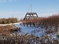
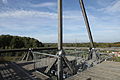
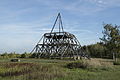
sculpture and observation tower on Halde Brockenscheid near Waltrop  | |||||
| Upload media | |||||
| Instance of | |||||
|---|---|---|---|---|---|
| Made from material | |||||
| Location | Waltrop, Recklinghausen, Münster Government Region, North Rhine-Westphalia, Germany | ||||
| Height |
| ||||
 | |||||
Media in category "Spurwerkturm"
The following 35 files are in this category, out of 35 total.
-
 Coal mine Waltrop Spurwerkturm 1.jpg 3,338 × 3,338; 2.88 MB
-
 Coal mine Waltrop Spurwerkturm 2.jpg 3,960 × 2,970; 3.84 MB
-
 Denkmal in Waltrop.JPG 3,840 × 2,160; 3.22 MB
-
 Halde Brockenscheidt 1.jpg 3,264 × 2,448; 2.62 MB
-
 Waltrop - Hiberniastraße + Halde Brockenscheidt 01 ies.jpg 5,616 × 3,744; 15.08 MB
-
 Waltrop - Landabsatz - Halde Brockenscheidt - Spurwerkturm 01 ies.jpg 5,616 × 3,744; 12.34 MB
-
 Waltrop - Landabsatz - Halde Brockenscheidt - Spurwerkturm 02 ies.jpg 5,616 × 3,744; 12.76 MB
-
 Waltrop - Landabsatz - Halde Brockenscheidt - Spurwerkturm 03 ies.jpg 5,616 × 3,744; 12.72 MB
-
 Waltrop - Landabsatz - Halde Brockenscheidt - Spurwerkturm 04 ies.jpg 3,744 × 5,616; 12.1 MB
-
 Waltrop - Landabsatz - Halde Brockenscheidt - Spurwerkturm 05 ies.jpg 5,616 × 3,744; 11.33 MB
-
 Waltrop - Landabsatz - Halde Brockenscheidt - Spurwerkturm 06 ies.jpg 3,744 × 5,616; 15.01 MB
-
 Waltrop - Landabsatz - Halde Brockenscheidt - Spurwerkturm 07 ies.jpg 5,616 × 3,744; 14.69 MB
-
 Waltrop - Landabsatz - Halde Brockenscheidt - Spurwerkturm 08 ies.jpg 5,616 × 3,744; 12.51 MB
-
 Waltrop - Landabsatz - Halde Brockenscheidt - Spurwerkturm 09 ies.jpg 5,616 × 3,744; 15.41 MB
-
 Waltrop - Landabsatz - Halde Brockenscheidt - Spurwerkturm 10 ies.jpg 3,744 × 5,616; 13.75 MB
-
 Waltrop - Landabsatz - Halde Brockenscheidt - Spurwerkturm 11 ies.jpg 5,616 × 3,744; 12.9 MB
-
 Waltrop - Landabsatz - Halde Brockenscheidt - Spurwerkturm 12 ies.jpg 5,616 × 3,744; 12.63 MB
-
 Waltrop - Landabsatz - Halde Brockenscheidt - Spurwerkturm 13 ies.jpg 5,616 × 3,744; 15.19 MB
-
 Waltrop - Landabsatz - Halde Brockenscheidt - Spurwerkturm 14 ies.jpg 5,616 × 3,744; 14.38 MB
-
 Waltrop - Landabsatz - Halde Brockenscheidt - Spurwerkturm 15 ies.jpg 5,616 × 3,744; 14.88 MB
-
 Waltrop - Landabsatz - Halde Brockenscheidt - Spurwerkturm 16 ies.jpg 3,744 × 5,616; 11.62 MB
-
 Waltrop - Landabsatz - Halde Brockenscheidt - Spurwerkturm 17 ies.jpg 5,616 × 3,744; 16.58 MB
-
 Waltrop - Landabsatz - Halde Brockenscheidt - Spurwerkturm 18 ies.jpg 5,616 × 3,744; 11.85 MB
-
 Waltrop - Landabsatz - Halde Brockenscheidt - Spurwerkturm 19 ies.jpg 5,616 × 3,744; 14.88 MB
-
 Waltrop - Landabsatz - Halde Brockenscheidt - Spurwerkturm 20 ies.jpg 3,744 × 5,616; 11.41 MB
-
 Waltrop - Landabsatz - Halde Brockenscheidt - Spurwerkturm 21 ies.jpg 5,616 × 3,744; 17.26 MB
-
 Waltrop - Landabsatz - Halde Brockenscheidt - Spurwerkturm 22 ies.jpg 5,616 × 3,744; 17.61 MB
-
 Waltrop - Landabsatz - Halde Brockenscheidt - Spurwerkturm 23 ies.jpg 5,616 × 3,744; 15.72 MB
-
 Waltrop - Landabsatz - Halde Brockenscheidt - Spurwerkturm 24 ies.jpg 5,616 × 3,744; 14.76 MB
-
 Waltrop - Landabsatz - Halde Brockenscheidt - Spurwerkturm 25 ies.jpg 5,616 × 3,744; 14.79 MB
-
 Waltrop - Landabsatz - Halde Brockenscheidt - Spurwerkturm 26 ies.jpg 5,616 × 3,744; 13.15 MB
-
 Waltrop - Landabsatz - Halde Brockenscheidt - Spurwerkturm 27 ies.jpg 3,744 × 5,616; 14.44 MB
-
 Waltrop - Landabsatz - Halde Brockenscheidt - Spurwerkturm 28 ies.jpg 5,616 × 3,744; 16.68 MB
-
 Waltrop - Landabsatz - Halde Brockenscheidt - Spurwerkturm 29 ies.jpg 5,616 × 3,744; 14.73 MB
-
 Waltrop - Landabsatz - Halde Brockenscheidt - Spurwerkturm 30 ies.jpg 5,616 × 3,744; 15.92 MB


