Category:Split Rock (Wyoming)
Jump to navigation
Jump to search
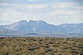
English: Split Rock (Wyoming)
| Camera location | | View all coordinates using: OpenStreetMap |
|---|
The wayside and monuments are along U.S. 287, west of the geologic feature.
| Camera location | | View all coordinates using: OpenStreetMap |
|---|
Media in category "Split Rock (Wyoming)"
The following 12 files are in this category, out of 12 total.
-
 $10000 Split Rock wolf.png 946 × 731; 1.34 MB
-
 From the West 2017-09- 1425.jpg 4,608 × 3,072; 3.97 MB
-
 From the West 2017-09- 1426.jpg 4,608 × 3,072; 3.15 MB
-
 Information 2017-09- 1401.jpg 4,608 × 2,592; 2.83 MB
-
 Split Rock Monument 2017-09- 1397.jpg 4,608 × 3,072; 3.61 MB
-
 Split Rock Monument 2017-09- 1398.jpg 3,072 × 4,608; 3.1 MB
-
 Split Rock Monument 2017-09- 1402.jpg 4,608 × 2,592; 4.78 MB
-
 View from west 2017-09- 1394.jpg 4,608 × 3,072; 3.07 MB
-
 View from west 2017-09- 1395.jpg 4,608 × 3,072; 3.28 MB
-
 View from west 2017-09- 1396.jpg 4,608 × 3,072; 2.82 MB
-
 View from west 2017-09- 1399.jpg 4,608 × 2,592; 2.82 MB
-
 View from west 2017-09- 1400.jpg 4,608 × 2,592; 3.01 MB


