Category:South Tibet (disputed territory)
Jump to navigation
Jump to search
conflict geographic area  | |||||
| Upload media | |||||
| Instance of | |||||
|---|---|---|---|---|---|
| Location |
| ||||
| Different from | |||||
| |||||
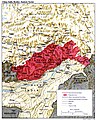
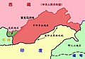
South Tibet (藏南; Zàngnán) is a term mainly used by the People's Republic of China (PRC) to refer to the territories located south of the McMahon Line, established through the Simla Accord (1913), administered by India as part of Arunachal Pradesh and Assam. The area is claimed by both the PRC and Taiwan.
Media in category "South Tibet (disputed territory)"
The following 7 files are in this category, out of 7 total.
-
 China India eastern border 88.jpg 1,019 × 1,265; 297 KB
-
 China India eastern border.jpg 1,048 × 1,294; 359 KB
-
 MacMahon Line.jpg 750 × 528; 46 KB
-
 增补藏南地区公开使用地名(第三批)分布图.jpg 5,827 × 4,114; 6.32 MB
-
 增补藏南地区公开使用地名(第二批).jpg 1,000 × 650; 168 KB
-
 增补藏南地区公开使用地名(第二批)分布图.jpg 5,827 × 4,114; 6.48 MB
-
 增补藏南地区公开使用地名(第四批)分布图.png 3,966 × 2,800; 6.57 MB


