Category:Sloepenloods, Brielle
Jump to navigation
Jump to search
| Object location | | View all coordinates using: OpenStreetMap |
|---|
.jpg) | |||||
| Upload media | |||||
| Instance of |
| ||||
|---|---|---|---|---|---|
| Location | Brielle, Voorne aan Zee, South Holland, Netherlands | ||||
| Street address |
| ||||
| Located on street | |||||
| Heritage designation |
| ||||
| Inception |
| ||||
| Date of official closure |
| ||||
 | |||||
|
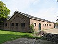
This is a category about rijksmonument number 518190
|
| Address |
|
Media in category "Sloepenloods, Brielle"
The following 5 files are in this category, out of 5 total.
-
 Overzicht sloepenloods - Brielle - 20377316 - RCE.jpg 1,200 × 956; 219 KB
-
 Overzicht vanaf de gracht - Brielle - 20377315 - RCE.jpg 1,200 × 1,200; 341 KB
-
 RM518190 Brielle - Maarland Noordzijde 104 (foto 1).jpg 2,592 × 1,944; 1.47 MB
-
 RM518190 Brielle - Maarland Noordzijde 104 (foto 2).jpg 2,592 × 1,944; 1.54 MB
-
 RM518190 Brielle - Maarland Noordzijde 104 (foto 3).jpg 2,592 × 1,944; 1.83 MB


.jpg)
.jpg)