Category:Slavery-related maps
Jump to navigation
Jump to search
Subcategories
This category has the following 2 subcategories, out of 2 total.
M
- Maps of the Third Servile War (27 F)
- Maps of the triangular trade (23 F)
Media in category "Slavery-related maps"
The following 59 files are in this category, out of 59 total.
-
-

-
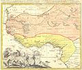
 1750 Bellin Map of the Senegal - Geographicus - Senegal-bellin-1750.jpg 1,985 × 2,784; 1.13 MB
-
 Abolition of slavery in the United States SVG map.svg 942 × 595; 183 KB
-
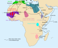
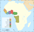 Africa slave Regions-ar.svg 1,525 × 1,440; 795 KB
-
 Africa slave Regions-es.svg 1,525 × 1,440; 565 KB
-
 Africa slave Regions.svg 1,525 × 1,440; 565 KB
-
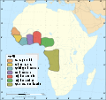
 African slave trade2-es.svg 1,525 × 1,440; 748 KB
-
 Alboran Sea map ar.svg 1,004 × 1,028; 420 KB
-
-
 Demerara rebellion of 1823 map.svg 940 × 477; 412 KB
-
 Emancipation Proclamation.PNG 1,513 × 983; 54 KB
-
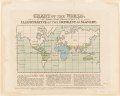
 Esclavatge - Comèrci mondiau sègle XVIII.png 2,727 × 2,249; 1,004 KB
-
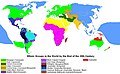 Ethnic Groups in the World.jpg 1,366 × 844; 593 KB
-
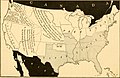
 Freeandslavestates.gif 570 × 384; 10 KB
-

-

-
 Joseph Cross, The Impolicy of Slavery, 1823 Cornell CUL PJM 1039 01.jpg 4,131 × 3,320; 2.19 MB
-
 Localisation du Memorail ACTe dans la Caraïbe.png 2,000 × 1,718; 211 KB
-

-
-
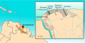
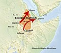 Map Slave Routes Ethiopia.jpg 772 × 667; 410 KB
-
 Maps Global Slavery Index 2019.png 1,239 × 530; 381 KB
-
 Medieval Arab Slave Trade.svg 13,834 × 11,508; 154 KB
-
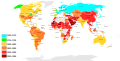
 Modern incidence of slavery.png 1,425 × 625; 53 KB
-
 Johnston's map of the United States of North America (NYPL b20643931-5564119).jpg 8,928 × 6,986; 58.21 MB
-
 OpenStreetMapPointsMentionsArticlesWikipédiaPortailEsclavageArticlesliés.png 1,077 × 791; 171 KB
-
 Proposed state of Kanawha (West Virginia) 1861 as first proposed.jpg 11,354 × 8,470; 34.33 MB
-
 Reynolds's Political Map of the United States 1856.jpg 7,813 × 7,090; 19.76 MB
-
 Ryans-mart-layout-sc1.jpg 250 × 250; 12 KB
-
 Slave and Free States before the American Civil War 2.svg 651 × 404; 110 KB
-
 Slave and Free States before the American Civil War-unbiased.png 800 × 502; 83 KB
-
 Slave and Free States before the American Civil War.svg 882 × 553; 105 KB
-
 Slave population.JPG 432 × 346; 45 KB
-
 SlavePopulationUS1860.jpg 10,503 × 8,380; 15.5 MB
-
 Slavery abolition.svg 2,754 × 1,398; 1.38 MB
-
 Slavery in the 13 colonies.jpg 550 × 611; 109 KB
-
 Slavery US 1820.png 600 × 790; 200 KB
-

-
 The free and slave states of America Wellcome V0050146.jpg 2,294 × 3,497; 3.39 MB
-
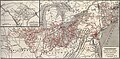
 The student's American history (1899) (14770946401).jpg 2,250 × 1,456; 364 KB
-
 Trafficking in Persons.svg 863 × 443; 1.66 MB
-
 Trafficking-in-persons-map-2010.png 2,753 × 1,400; 119 KB
-
 Traite musulmane medievale-es.svg 799 × 663; 358 KB
-
 Undergroundrailroadsmall2.jpg 1,035 × 600; 274 KB
-
 United States Slavery Map 1860.jpg 1,903 × 1,146; 455 KB
-
 United States 1860-1870.gif 787 × 483; 49 KB
-
 United States Slavery Map 1860-sw.jpg 1,200 × 672; 167 KB
-
 US Slave Free 1789-1861-de.gif 774 × 468; 111 KB
-
 US Slave Free 1789-1861.gif 774 × 468; 100 KB
-
 US SlaveFree1789.gif 774 × 468; 20 KB
-
 US SlaveFree1800.gif 774 × 468; 22 KB
-
 US SlaveFree1821.gif 774 × 468; 24 KB
-
 US SlaveFree1837.gif 774 × 468; 24 KB
-
 US SlaveFree1846 2.gif 774 × 468; 22 KB
-
 US SlaveFree1846 Wilmot.gif 774 × 468; 26 KB
-
 US SlaveFree1858.gif 774 × 468; 25 KB
-
 US SlaveFree1860.gif 774 × 468; 25 KB
-
 Vereinigte Staaten 1837 freie und Sklavenstaaten.png 1,000 × 627; 82 KB
_%22Guinea%22_-_Geographicus_-_Aethiopia-hmhr-1743.jpg)


.jpg)
_1861_as_first_proposed_(cropped).jpg)


.jpg)

_1861_as_first_proposed.jpg)


_(14586753370).jpg)

_(14770946401).jpg)


