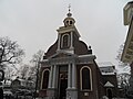
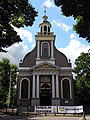
Category:Sint Petrus' Banden (Driebergen-Rijsenburg)
Jump to navigation
Jump to search
| Object location | | View all coordinates using: OpenStreetMap |
|---|
church building in Utrechtse Heuvelrug, Netherlands  | |||||
| Upload media | |||||
| Instance of | |||||
|---|---|---|---|---|---|
| Dedicated to | |||||
| Location | Driebergen-Rijsenburg, Utrecht, Netherlands | ||||
| Street address |
| ||||
| Located on street | |||||
| Architect | |||||
| Heritage designation |
| ||||
| Inception |
| ||||
| Religion or worldview | |||||
 | |||||
Nederlands: Petrus Bandenkerk - anno 1809
|
This is a category about rijksmonument number 14099
|
| Address |
|
Media in category "Sint Petrus' Banden (Driebergen-Rijsenburg)"
The following 56 files are in this category, out of 56 total.
-
 Altar.SintPetrusBanden.Driebergen-Rijsenburg.JPG 3,039 × 2,278; 1.49 MB
-
 DRIEBERGEN ST.PETRUSBANDENKERK.jpg 2,592 × 4,608; 1.5 MB
-
 En kerkplein - Driebergen-Rijsenburg - 20063850 - RCE.jpg 1,200 × 1,180; 417 KB
-
 En kerkplein - Driebergen-Rijsenburg - 20063851 - RCE.jpg 1,200 × 1,186; 357 KB
-
 Exterieur met plein, reproductie van oude foto - Rijsenburg - 20187534 - RCE.jpg 1,200 × 877; 285 KB
-
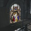
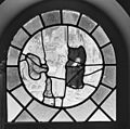 Exterieur OVERZICHT GLAS IN LOODRAAM (RBK) - Rijsenburg - 20298834 - RCE.jpg 1,200 × 1,185; 294 KB
-
 Exterieur toegankelijkheid voor invaliden - Rijsenburg - 20187535 - RCE.jpg 1,188 × 1,200; 424 KB
-
 Gebrandschilderd raam - Rijsenburg - 20187523 - RCE.jpg 1,190 × 1,200; 274 KB
-
 Gebrandschilderd raam - Rijsenburg - 20187524 - RCE.jpg 1,190 × 1,200; 258 KB
-
 Gebrandschilderd raam - Rijsenburg - 20187525 - RCE.jpg 1,190 × 1,200; 273 KB
-
 Gebrandschilderd raam - Rijsenburg - 20187526 - RCE.jpg 1,192 × 1,200; 249 KB
-
 Gebrandschilderd raam - Rijsenburg - 20187527 - RCE.jpg 1,200 × 1,197; 254 KB
-
 Gebrandschilderd raam - Rijsenburg - 20187528 - RCE.jpg 1,190 × 1,200; 245 KB
-

-

-
 Interieur - Rijsenburg - 20187521 - RCE.jpg 1,200 × 799; 144 KB
-
 Interieur - Rijsenburg - 20187522 - RCE.jpg 803 × 1,200; 135 KB
-
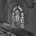
 Interieur koor - Rijsenburg - 20187529 - RCE.jpg 1,200 × 950; 142 KB
-
 Interieur naar het westen - Rijsenburg - 20187530 - RCE.jpg 951 × 1,200; 154 KB
-
 Interieur naar het zuid-westen - Rijsenburg - 20187532 - RCE.jpg 960 × 1,200; 158 KB
-
 Interieur naar het zuidtransept - Rijsenburg - 20187533 - RCE.jpg 961 × 1,200; 136 KB
-

-
 Interieur sacristie, gebrandschilderd glas - Driebergen-Rijsenburg - 20365922 - RCE.jpg 1,200 × 1,199; 258 KB
-
 Interieur schip naar het westen - Rijsenburg - 20187531 - RCE.jpg 960 × 1,200; 169 KB
-

-

-
 Interieur, ciborie - Driebergen-Rijsenburg - 20002489 - RCE.jpg 1,192 × 1,200; 168 KB
-
 Interieur, ciborie - Driebergen-Rijsenburg - 20370837 - RCE.jpg 1,197 × 1,200; 163 KB
-

-
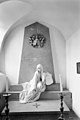 Interieur, grafkapel - Driebergen-Rijsenburg - 20002488 - RCE.jpg 803 × 1,200; 149 KB
-

-
 INTERIEUR, OVERZICHT GLAS IN LOODRAAM (RBK) - Rijsenburg - 20298835 - RCE.jpg 960 × 1,200; 238 KB
-
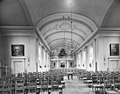
 Interieur, overzicht naar het koor - Driebergen-Rijsenburg - 20002486 - RCE.jpg 1,200 × 945; 204 KB
-

-
-
-

-

-

-

-

-
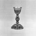 Interieur, zilveren kelk - Driebergen-Rijsenburg - 20370835 - RCE.jpg 1,197 × 1,200; 175 KB
-
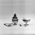 Interieur, zilveren wierrookvat en scheepje - Driebergen-Rijsenburg - 20370834 - RCE.jpg 1,200 × 1,197; 154 KB
-
 Interior.SintPetrusBanden.Driebergen-Rijsenburg.JPG 3,648 × 2,736; 2.27 MB
-
 KerkOpPleinInDriebergen2009.jpg 3,072 × 2,304; 2.94 MB
-
 Kerkplein Driebergen-Rijssenburg.jpg 4,404 × 2,464; 2.16 MB
-
 OosthuyseChapel.SintPetrusBanden.Driebergen-Rijsenburg.JPG 2,736 × 3,648; 2.07 MB
-

-
 Overzicht van af de Hoofdstraat - Rijsenburg - 20187543 - RCE.jpg 1,200 × 961; 261 KB
-
 Overzicht westgevel - Driebergen-Rijsenburg - 20002477 - RCE.jpg 950 × 1,200; 318 KB
-
 Overzicht westgevel met omgeving - Driebergen-Rijsenburg - 20063852 - RCE.jpg 894 × 1,200; 307 KB
-
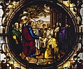 Rijsenburg - detail Petrusraam (1841) van Joannes van Rijckevorsel.jpg 1,245 × 1,026; 355 KB
-
 Sint Petrus bandenkerk.jpg 900 × 675; 99 KB
-
 SintPetrusBanden.Driebergen-Rijsenburg.JPG 2,736 × 3,648; 2.01 MB
-
 Verbod voor vrouwen om met kniekousen of halve kousen ter communie te gaan.jpeg 6,017 × 3,885; 3.02 MB
-
 Voorgevel - Rijsenburg - 20187520 - RCE.jpg 802 × 1,200; 196 KB


_-_Rijsenburg_-_20298834_-_RCE.jpg)


_-_Rijsenburg_-_20298835_-_RCE.jpg)


_van_Joannes_van_Rijckevorsel.jpg)


