Category:Sint Martinus, Didam
Jump to navigation
Jump to search
| Object location | | View all coordinates using: OpenStreetMap |
|---|
windmill in Didam, Gelderland, Netherlands  | |||||
| Upload media | |||||
| Instance of | |||||
|---|---|---|---|---|---|
| Location | Didam, Montferland, Gelderland, Netherlands | ||||
| Street address |
| ||||
| Has use | |||||
| Heritage designation |
| ||||
| Inception |
| ||||
| Source of energy | |||||
 | |||||
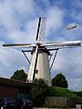
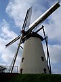
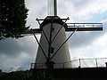
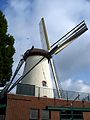
Nederlands: De windmolen Sint Martinus in Didam (in de gemeente Montferland in de Nederlandse provincie Gelderland) is een ronde stenen beltmolen uit 1855.
|
This is a category about rijksmonument number 12869
|
| Address |
|
Media in category "Sint Martinus, Didam"
The following 25 files are in this category, out of 25 total.
-
 2023 Didam, Sint-Martensmûne.jpg 2,604 × 2,605; 3.06 MB
-

-
 Baard van korenmolen St. Martinus te Didam - Didam - 20056869 - RCE.jpg 1,200 × 788; 180 KB
-
 Didam StMartinus 01.JPG 3,000 × 4,000; 1.46 MB
-
 Didam StMartinus 02.JPG 3,000 × 4,000; 1.46 MB
-
 Didam StMartinus 03.JPG 3,000 × 4,000; 1.4 MB
-
 Didam StMartinus 04.JPG 4,000 × 3,000; 1.01 MB
-
 Didam StMartinus 05.JPG 4,000 × 3,000; 1.24 MB
-
 Didam StMartinus 06.JPG 3,000 × 4,000; 1.66 MB
-
 Didam, molen Sint Martinus foto5 2010-07-17 12.49.JPG 2,592 × 3,456; 3.54 MB
-

-
 Ronde stenen beltmolen schuin van opzij gefotografeerd - Didam - 20056871 - RCE.jpg 1,200 × 1,183; 189 KB
-

-

-

-

-
 Ronde stenen beltmolen van opzij gefotografeerd - Didam - 20362242 - RCE.jpg 1,200 × 1,193; 161 KB
-

-

-

-

-

-
 Ronde stenen beltmolen van voren gefotografeerd - Didam - 20362243 - RCE.jpg 1,200 × 1,196; 184 KB
-
 Ronde stenen beltmolen van voren gefotografeerd - Didam - 20362244 - RCE.jpg 1,200 × 1,200; 181 KB
-


