Category:Sint-Vincentiuskerk (Amsterdam)
Jump to navigation
Jump to search
| Object location | | View all coordinates using: OpenStreetMap |
|---|
 | |||||
| Upload media | |||||
| Instance of | |||||
|---|---|---|---|---|---|
| Named after | |||||
| Dedicated to | |||||
| Location | Amsterdam Oud-West, Amsterdam-West, Amsterdam, North Holland, Netherlands | ||||
| Street address |
| ||||
| Located on street | |||||
| Inception |
| ||||
| Dissolved, abolished or demolished date |
| ||||
| Religion or worldview | |||||
| official website | |||||
 | |||||
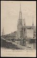
Nederlands: Amsterdam, Jacob van Lennepkade - Vincentius a Paulokerk (1901 - 1989)
English: Vincentius church in Amsterdam (West).
| Address |
|
Media in category "Sint-Vincentiuskerk (Amsterdam)"
The following 26 files are in this category, out of 26 total.
-
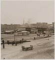 Columbusplein in aanbouw - Stadsarchief Amsterdam, Afb OSIM00004001993.jpg 1,956 × 2,124; 334 KB
-
 Jacob van Lennepkade - Vincentiuskerk (ansichtkaart, kleur) 1907.jpg 1,280 × 813; 489 KB
-
 Jacob van Lennepkade - Vincentiuskerk (ansichtkaart,) ~1930.jpg 612 × 960; 88 KB
-
 Jacob van Lennepkade met links de R.K. Kerk Vincentius a Paulo, Afb B00000008249.jpg 1,698 × 1,145; 422 KB
-
-
 Kijkdagen, veilingen, inboedels, kerken, Bestanddeelnr 934-4315.jpg 3,712 × 2,445; 2.22 MB
-
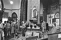
 Kinderen bekijken een biechtstoel, Bestanddeelnr 934-4316.jpg 3,712 × 2,445; 2.02 MB
-
 Stadsarchief Amsterdam, Afb ANWR00280000001.jpg 1,472 × 1,667; 206 KB
-
 Staringplein 2-6a - Stadsarchief Amsterdam, Afb ANWR00322000001.jpg 2,006 × 1,480; 400 KB
-

-

-
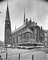
 Van Lennepkade en Vincentiuskerk - Amsterdam - 20305489 - RCE.jpg 1,200 × 960; 227 KB
-
 Van Lennepkade en Vincentiuskerk - Amsterdam - 20305494 - RCE.jpg 960 × 1,200; 242 KB
-
 Van Lennepkade en Vincentiuskerk - Stadsarchief Amsterdam, Afb B00000008251.jpg 1,718 × 1,137; 287 KB
-
 Vincentiuskerk (1990) Amsterdam.jpg 1,600 × 1,200; 690 KB
-
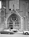
 Vincentiuskerk - Amsterdam - 20305490 - RCE.jpg 944 × 1,200; 271 KB
-
 Vincentiuskerk - Amsterdam - 20305491 - RCE.jpg 949 × 1,200; 212 KB
-
 Vincentiuskerk - Amsterdam - 20305492 - RCE.jpg 952 × 1,200; 324 KB
-
 Vincentiuskerk - Amsterdam - 20305493 - RCE.jpg 958 × 1,200; 229 KB
-
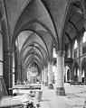
 Vincentiuskerk, interieur tijdens sloop - Amsterdam - 20305495 - RCE.jpg 959 × 1,200; 265 KB
-
 Vincentiuskerk, interieur tijdens sloop - Amsterdam - 20305496 - RCE.jpg 951 × 1,200; 287 KB
-
 Vincentiuskerk, interieur tijdens sloop - Amsterdam - 20305497 - RCE.jpg 942 × 1,200; 260 KB
-
 Vincentiuskerk, Interieur tijdens sloop - Amsterdam - 20305498 - RCE.jpg 956 × 1,200; 267 KB
-
 Vincentiuskerk, interieur tijdens sloop - Amsterdam - 20305499 - RCE.jpg 953 × 1,200; 298 KB
-
 Vincentiuskerk, interieur tijdens sloop - Amsterdam - 20305500 - RCE.jpg 946 × 1,200; 291 KB
-
 Vincentiuskerk, zijaltaar oostzijde - Amsterdam - 20305501 - RCE.jpg 958 × 1,200; 280 KB

_1907.jpg)
_~1930.jpg)


_in_Amsterdam_tegen_regime_in_Turkije,_Bestanddeelnr_932-2006.jpg)
_in_Amsterdam_tegen_regime_in_Turkije,_Bestanddeelnr_932-2007.jpg)


_Amsterdam.jpg)


