Category:Sint-Jozefkerk, Delfzijl
Jump to navigation
Jump to search
| Object location | | View all coordinates using: OpenStreetMap |
|---|
 | |||||
| Upload media | |||||
| Instance of | |||||
|---|---|---|---|---|---|
| Part of | |||||
| Location | Delfzijl, Eemsdelta, Groningen, Netherlands | ||||
| Street address |
| ||||
| Located on street |
| ||||
| Heritage designation |
| ||||
 | |||||
Nederlands: Roman Catholic Church, Delfzijl
|
This is a category about rijksmonumentcomplex number 516182
|
|
This is a category about rijksmonument number 516183
|
|
This is a category about rijksmonument number 516184
|
| Address |
|
Media in category "Sint-Jozefkerk, Delfzijl"
The following 55 files are in this category, out of 55 total.
-
-

-
 Delfzijl, kerk1 foto2 2009-06-28 13.59.JPG 1,704 × 2,272; 1.06 MB
-

-
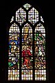 Interieur, , glas-in-loodraam in het transept - Delfzijl - 20530630 - RCE.jpg 800 × 1,200; 208 KB
-
 Interieur, doopvont - Delfzijl - 20530614 - RCE.jpg 800 × 1,200; 140 KB
-

-

-
 Interieur, glas-in-loodraam in het koor - Delfzijl - 20530624 - RCE.jpg 800 × 1,200; 123 KB
-
 Interieur, glas-in-loodraam in het koor - Delfzijl - 20530625 - RCE.jpg 800 × 1,200; 129 KB
-
 Interieur, glas-in-loodraam in het koor - Delfzijl - 20530626 - RCE.jpg 800 × 1,200; 119 KB
-
 Interieur, glas-in-loodraam in het koor - Delfzijl - 20530627 - RCE.jpg 800 × 1,200; 121 KB
-
 Interieur, glas-in-loodraam in het koor - Delfzijl - 20530628 - RCE.jpg 800 × 1,200; 95 KB
-
 Interieur, glas-in-loodraam in het transept - Delfzijl - 20530629 - RCE.jpg 800 × 1,200; 188 KB
-
 Interieur, hangend kruisbeeld in de viering - Delfzijl - 20530613 - RCE.jpg 800 × 1,200; 137 KB
-
-
-
 Interieur, kerkbanken in het schip - Delfzijl - 20530611 - RCE.jpg 1,200 × 800; 167 KB
-
 Interieur, kleuronderzoek in de kerk - Delfzijl - 20530618 - RCE.jpg 1,200 × 800; 102 KB
-
 Interieur, kleuronderzoek in de kerk - Delfzijl - 20530619 - RCE.jpg 800 × 1,200; 92 KB
-
 Interieur, kleuronderzoek op een van de pilaren - Delfzijl - 20530617 - RCE.jpg 800 × 1,200; 146 KB
-
-

-
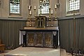
 Interieur, overzicht hoofdaltaar - Delfzijl - 20530609 - RCE.jpg 1,200 × 800; 156 KB
-
 Interieur, overzicht hoofdaltaar - Delfzijl - 20530610 - RCE.jpg 1,200 × 800; 154 KB
-
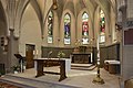 Interieur, overzicht koor met altaar - Delfzijl - 20530607 - RCE.jpg 1,200 × 800; 166 KB
-
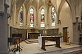 Interieur, overzicht koor met altaar - Delfzijl - 20530608 - RCE.jpg 1,200 × 800; 168 KB
-
-

-
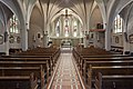
 Interieur, overzicht naar het noordoosten - Delfzijl - 20530603 - RCE.jpg 1,200 × 800; 164 KB
-

-
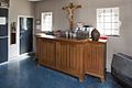
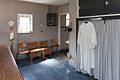 Interieur, overzicht sacristie - Delfzijl - 20530623 - RCE.jpg 1,200 × 800; 118 KB
-

-

-
 Interieur, vloer met tegels in het schip - Delfzijl - 20530612 - RCE.jpg 800 × 1,200; 178 KB
-

-
-
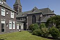
 Overzicht achtergevel met rechts de kerk - Delfzijl - 20530594 - RCE.jpg 1,200 × 800; 210 KB
-

-
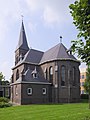
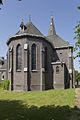 Overzicht oostzijde van de kerk, koor - Delfzijl - 20530598 - RCE.jpg 800 × 1,200; 187 KB
-
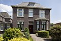
 Overzicht pastorie en de westzijde van de kerk - Delfzijl - 20530584 - RCE.jpg 1,200 × 800; 184 KB
-

-

-
-

-

-

-

-

-
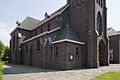
 Overzicht zuidoostzijde van de kerk - Delfzijl - 20530597 - RCE.jpg 800 × 1,200; 204 KB
-
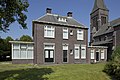
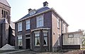 Pastorie Sint-Josephkerk Delfzijl.jpg 1,824 × 1,152; 418 KB
-
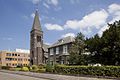
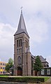
 Sint-Josephkerk Delfzijl.jpg 1,368 × 1,596; 440 KB
-
 Sint-Jozefkerk, Delfzijl 1416.jpg 2,796 × 4,601; 3.89 MB
-
 Sint-Jozefkerk, Delfzijl 1430.jpg 3,464 × 4,632; 7.23 MB
-
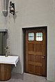
 Westgevel van de kerktoren met ingangspartij - Delfzijl - 20530587 - RCE.jpg 800 × 1,200; 197 KB


_met_omgeving_-_Delfzijl_-_20530583_-_RCE.jpg)


