Category:Siegfried-Rädel-Straße (Pirna)
Jump to navigation
Jump to search
| Object location | | View all coordinates using: OpenStreetMap |
|---|

street in Pirna, Saxony, Germany | |||||
| Upload media | |||||
| Instance of | |||||
|---|---|---|---|---|---|
| Location | Pirna, Sächsische Schweiz-Osterzgebirge, Saxony, Germany | ||||
 | |||||
Subcategories
This category has the following 13 subcategories, out of 13 total.
A
- Allotment "Fortschritt", Pirna (29 F)
B
H
- Hospitalkrankenhaus Pirna (1 F)
O
- OBI (Pirna) (36 F)
R
S
- Siegfried Rädel Straße 13, Pirna (46 F)
- Sächsische Sandsteinwerke GmbH (111 F)
Media in category "Siegfried-Rädel-Straße (Pirna)"
The following 200 files are in this category, out of 270 total.
(previous page) (next page)-
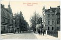
 17665-Pirna-1914-Kaiser-Wilhelm-Straße-Brück & Sohn Kunstverlag.jpg 1,507 × 1,000; 494 KB
-
 17666-Pirna-1914-Weststraße-Brück & Sohn Kunstverlag.jpg 1,512 × 1,000; 502 KB
-
 2007072201 DDR-Moped Habicht.jpg 3,008 × 2,008; 4.22 MB
-
 2007072202 DDR-Moped Habicht.jpg 2,008 × 3,008; 4.3 MB
-
 Absperrung Kanalarbeiten Siegfried-Raedel-Strasse Pirna 2019.jpg 6,016 × 4,000; 12.91 MB
-
 Brachgrundstueck Siegfried-Raedel-Strasse 2020.jpg 6,016 × 4,000; 13.08 MB
-
 Breite-strasse-26 zentralperspektive 2022.jpg 6,016 × 4,000; 7.04 MB
-
 Brunnen auf dem Gelände des Hospitalkrankenhauses Siegfried-Rädel-Straße 11.jpg 6,016 × 4,000; 10.99 MB
-
 DDR-Moped Habicht 2007.jpg 3,008 × 2,008; 4.22 MB
-
 Elbe-Hochwasser in Pirna-Juni 2013-108.JPG 4,320 × 2,432; 1.39 MB
-
 Elbe-Hochwasser in Pirna-Juni 2013-109.JPG 4,320 × 2,432; 1.16 MB
-
 Gottleuba 2021.jpg 6,016 × 4,000; 17.42 MB
-
 Hospitalkirche und Brunnen Siegfried-Räde-St. 11.jpg 6,016 × 4,000; 12.93 MB
-
 Hospitalstraße Pirna (42466781621).jpg 3,648 × 2,736; 4.87 MB
-
 Karl Liebknecht Straße Pirna - Siegfried Rädel Straße Pirna (43841004134).jpg 1,297 × 1,727; 1.18 MB
-
 Karl Liebknecht Straße Pirna - Siegfried Rädel Straße Pirna (43841004814).jpg 1,944 × 2,592; 2.31 MB
-
 Karl Liebknecht Straße Pirna - Siegfried Rädel Straße Pirna (44509762072).jpg 1,298 × 1,727; 1.21 MB
-
 KLS - SRS Pirna 2018 moza.jpg 1,298 × 1,727; 1.09 MB
-
 PIR Gottleuba (01) 2006-03-31.jpg 1,432 × 835; 1.2 MB
-

-
 Pirna, Germany - panoramio (2516).jpg 5,184 × 3,888; 15.23 MB
-
 S R Straße Pirna 2018 Casa verde.jpg 3,578 × 2,642; 4.91 MB
-
 Siegfried R Straße Pirna 2018 18.jpg 3,648 × 2,736; 5.89 MB
-
 Siegfried Rädel Straße Pirna (27876622667).jpg 3,648 × 2,736; 4.45 MB
-
 Siegfried Rädel Straße Pirna (27876723377).jpg 3,648 × 2,736; 4.41 MB
-
 Siegfried Rädel Straße Pirna (27876740357).jpg 3,648 × 2,736; 4.3 MB
-
 Siegfried Rädel Straße Pirna (27877057087).jpg 3,648 × 2,736; 4.19 MB
-
 Siegfried Rädel Straße Pirna (27877097037).jpg 3,648 × 2,736; 4.48 MB
-
 Siegfried Rädel Straße Pirna (27877183197).jpg 3,648 × 2,736; 4.13 MB
-
 Siegfried Rädel Straße Pirna (27877222967).jpg 3,648 × 2,736; 4.35 MB
-
 Siegfried Rädel Straße Pirna (27877394487).jpg 3,648 × 2,736; 5.22 MB
-
 Siegfried Rädel Straße Pirna (27877429867).jpg 3,648 × 2,736; 4.84 MB
-
 Siegfried Rädel Straße Pirna (27877793477).jpg 3,648 × 2,736; 4.11 MB
-
 Siegfried Rädel Straße Pirna (27877846587).jpg 3,482 × 2,498; 3.57 MB
-
 Siegfried Rädel Straße Pirna (27877895637).jpg 3,648 × 2,736; 4.99 MB
-
 Siegfried Rädel Straße Pirna (27877981047).jpg 3,492 × 2,514; 3.48 MB
-
 Siegfried Rädel Straße Pirna (27878088117).jpg 3,648 × 2,736; 4.34 MB
-
 Siegfried Rädel Straße Pirna (27878177397).jpg 3,648 × 2,736; 4.71 MB
-
 Siegfried Rädel Straße Pirna (27878272027).jpg 3,648 × 2,736; 5.1 MB
-
 Siegfried Rädel Straße Pirna (27878510417).jpg 3,648 × 2,736; 3.78 MB
-
 Siegfried Rädel Straße Pirna (28316259927).jpg 5,184 × 2,920; 6.4 MB
-
 Siegfried Rädel Straße Pirna (28316289147).jpg 5,184 × 2,920; 5.53 MB
-
 Siegfried Rädel Straße Pirna (28316365217).jpg 5,184 × 2,920; 6.88 MB
-
 Siegfried Rädel Straße Pirna (28316599017).jpg 5,184 × 2,920; 7.19 MB
-
 Siegfried Rädel Straße Pirna (28316643047).jpg 3,648 × 2,736; 5.15 MB
-
 Siegfried Rädel Straße Pirna (28872339318).jpg 3,648 × 2,736; 4.64 MB
-
 Siegfried Rädel Straße Pirna (28872417198).jpg 3,648 × 2,736; 4.88 MB
-
 Siegfried Rädel Straße Pirna (28872467248).jpg 3,648 × 2,736; 4.68 MB
-
 Siegfried Rädel Straße Pirna (28872649248).jpg 3,648 × 2,736; 4.11 MB
-
 Siegfried Rädel Straße Pirna (28872838608).jpg 3,648 × 2,736; 5.94 MB
-
 Siegfried Rädel Straße Pirna (28873041188).jpg 3,648 × 2,736; 4.69 MB
-
 Siegfried Rädel Straße Pirna (28873089708).jpg 3,648 × 2,736; 4.27 MB
-
 Siegfried Rädel Straße Pirna (28873111468).jpg 3,648 × 2,736; 4.81 MB
-
 Siegfried Rädel Straße Pirna (28873196688).jpg 3,614 × 2,690; 5.13 MB
-
 Siegfried Rädel Straße Pirna (28873238438).jpg 3,524 × 2,562; 3.93 MB
-
 Siegfried Rädel Straße Pirna (28873430738).jpg 3,648 × 2,736; 5.68 MB
-
 Siegfried Rädel Straße Pirna (28873576258).jpg 3,648 × 2,736; 5.16 MB
-
 Siegfried Rädel Straße Pirna (28873605318).jpg 3,648 × 2,736; 5.65 MB
-
 Siegfried Rädel Straße Pirna (28873626898).jpg 3,552 × 2,604; 4.36 MB
-
 Siegfried Rädel Straße Pirna (28873664418).jpg 3,602 × 2,674; 4.38 MB
-
 Siegfried Rädel Straße Pirna (28873756238).jpg 3,648 × 2,736; 4.46 MB
-
 Siegfried Rädel Straße Pirna (28873803078).jpg 3,648 × 2,736; 4.33 MB
-
 Siegfried Rädel Straße Pirna (28873999898).jpg 2,562 × 3,524; 4.95 MB
-
 Siegfried Rädel Straße Pirna (28874207398).jpg 3,648 × 2,736; 5.04 MB
-
 Siegfried Rädel Straße Pirna (40935016280).jpg 3,648 × 2,736; 6.83 MB
-
 Siegfried Rädel Straße Pirna (40935321440).jpg 3,648 × 2,736; 4.31 MB
-
 Siegfried Rädel Straße Pirna (40935465990).jpg 3,648 × 2,736; 6.24 MB
-
 Siegfried Rädel Straße Pirna (40935567740).jpg 3,648 × 2,736; 5.05 MB
-
 Siegfried Rädel Straße Pirna (40935711780).jpg 3,648 × 2,736; 4.76 MB
-
 Siegfried Rädel Straße Pirna (40935843230).jpg 3,648 × 2,736; 5.26 MB
-
 Siegfried Rädel Straße Pirna (40935907710).jpg 3,648 × 2,736; 4.28 MB
-
 Siegfried Rädel Straße Pirna (40935971670).jpg 2,736 × 3,648; 4.79 MB
-
 Siegfried Rädel Straße Pirna (40936001340).jpg 3,448 × 2,444; 4.35 MB
-
 Siegfried Rädel Straße Pirna (40936143820).jpg 3,498 × 2,522; 4.81 MB
-
 Siegfried Rädel Straße Pirna (40936456570).jpg 3,648 × 2,736; 5.05 MB
-
 Siegfried Rädel Straße Pirna (40936470740).jpg 3,648 × 2,736; 4.72 MB
-
 Siegfried Rädel Straße Pirna (40936517990).jpg 3,528 × 2,570; 3.41 MB
-
 Siegfried Rädel Straße Pirna (40936630550).jpg 3,648 × 2,736; 4.51 MB
-
 Siegfried Rädel Straße Pirna (41375409110).jpg 3,648 × 2,736; 4.93 MB
-
 Siegfried Rädel Straße Pirna (41378865050).jpg 5,128 × 2,816; 5.45 MB
-
 Siegfried Rädel Straße Pirna (41845789795).jpg 3,648 × 2,736; 4.6 MB
-
 Siegfried Rädel Straße Pirna (41845812355).jpg 3,646 × 2,732; 4.21 MB
-
 Siegfried Rädel Straße Pirna (41845994605).jpg 3,648 × 2,736; 4.04 MB
-
 Siegfried Rädel Straße Pirna (41846266545).jpg 3,586 × 2,652; 3.38 MB
-
 Siegfried Rädel Straße Pirna (41846292535).jpg 3,648 × 2,736; 3.39 MB
-
 Siegfried Rädel Straße Pirna (41846320405).jpg 3,648 × 2,736; 4.25 MB
-
 Siegfried Rädel Straße Pirna (41846360265).jpg 3,648 × 2,736; 3.4 MB
-
 Siegfried Rädel Straße Pirna (41846428105).jpg 3,648 × 2,736; 5.26 MB
-
 Siegfried Rädel Straße Pirna (41846497955).jpg 3,648 × 2,736; 5.2 MB
-
 Siegfried Rädel Straße Pirna (41846612375).jpg 3,514 × 2,546; 4.8 MB
-
 Siegfried Rädel Straße Pirna (41846812875).jpg 3,648 × 2,736; 5.61 MB
-
 Siegfried Rädel Straße Pirna (41846969445).jpg 3,648 × 2,736; 5.72 MB
-
 Siegfried Rädel Straße Pirna (41847185635).jpg 3,648 × 2,736; 4.96 MB
-
 Siegfried Rädel Straße Pirna (41847203375).jpg 2,736 × 3,648; 4.92 MB
-
 Siegfried Rädel Straße Pirna (41847339515).jpg 2,736 × 3,648; 6.9 MB
-
 Siegfried Rädel Straße Pirna (41847620115).jpg 3,648 × 2,736; 3.7 MB
-
 Siegfried Rädel Straße Pirna (42028500594).jpg 3,648 × 2,736; 4.19 MB
-
 Siegfried Rädel Straße Pirna (42028539504).jpg 3,648 × 2,736; 5.35 MB
-
 Siegfried Rädel Straße Pirna (42028650454).jpg 3,648 × 2,736; 4.8 MB
-
 Siegfried Rädel Straße Pirna (42028847804).jpg 3,648 × 2,736; 3.18 MB
-
 Siegfried Rädel Straße Pirna (42029075164).jpg 3,648 × 2,736; 5.11 MB
-
 Siegfried Rädel Straße Pirna (42029239464).jpg 3,648 × 2,736; 5.25 MB
-
 Siegfried Rädel Straße Pirna (42029269344).jpg 3,648 × 2,736; 4.53 MB
-
 Siegfried Rädel Straße Pirna (42029322444).jpg 3,648 × 2,736; 4.07 MB
-
 Siegfried Rädel Straße Pirna (42029660664).jpg 3,648 × 2,736; 3.87 MB
-
 Siegfried Rädel Straße Pirna (42029733064).jpg 3,648 × 2,736; 5.65 MB
-
 Siegfried Rädel Straße Pirna (42029785034).jpg 3,534 × 2,576; 3.5 MB
-
 Siegfried Rädel Straße Pirna (42029796374).jpg 3,648 × 2,736; 4.24 MB
-
 Siegfried Rädel Straße Pirna (42029841824).jpg 3,648 × 2,736; 4.1 MB
-
 Siegfried Rädel Straße Pirna (42029945694).jpg 3,648 × 2,736; 3.81 MB
-
 Siegfried Rädel Straße Pirna (42029954714).jpg 3,648 × 2,736; 3.99 MB
-
 Siegfried Rädel Straße Pirna (42029976514).jpg 3,648 × 2,736; 5.72 MB
-
 Siegfried Rädel Straße Pirna (42281504785).jpg 5,184 × 2,920; 6.35 MB
-
 Siegfried Rädel Straße Pirna (42281526255).jpg 5,184 × 2,920; 7.1 MB
-
 Siegfried Rädel Straße Pirna (42281578115).jpg 5,184 × 2,920; 6.21 MB
-
 Siegfried Rädel Straße Pirna (42281596045).jpg 3,648 × 2,736; 5.49 MB
-
 Siegfried Rädel Straße Pirna (42467358414).jpg 5,184 × 2,920; 6.09 MB
-
 Siegfried Rädel Straße Pirna (42467679774).jpg 5,052 × 2,658; 6.14 MB
-
 Siegfried Rädel Straße Pirna (42469168354).jpg 5,184 × 2,920; 7.2 MB
-
 Siegfried Rädel Straße Pirna (42696496162).jpg 3,648 × 2,736; 4.34 MB
-
 Siegfried Rädel Straße Pirna (42696525212).jpg 3,648 × 2,736; 5.31 MB
-
 Siegfried Rädel Straße Pirna (42696566132).jpg 3,648 × 2,736; 5.21 MB
-
 Siegfried Rädel Straße Pirna (42696644012).jpg 3,648 × 2,736; 4.55 MB
-
 Siegfried Rädel Straße Pirna (42696713622).jpg 3,648 × 2,736; 5.05 MB
-
 Siegfried Rädel Straße Pirna (42696730152).jpg 3,648 × 2,736; 4.76 MB
-
 Siegfried Rädel Straße Pirna (42696851452).jpg 3,648 × 2,736; 5.15 MB
-
 Siegfried Rädel Straße Pirna (42696945652).jpg 3,648 × 2,736; 3.44 MB
-
 Siegfried Rädel Straße Pirna (42696972852).jpg 3,648 × 2,736; 3.64 MB
-
 Siegfried Rädel Straße Pirna (42697004812).jpg 3,648 × 2,736; 3.81 MB
-
 Siegfried Rädel Straße Pirna (42697084772).jpg 3,648 × 2,736; 5.43 MB
-
 Siegfried Rädel Straße Pirna (42697268712).jpg 2,736 × 3,648; 3.9 MB
-
 Siegfried Rädel Straße Pirna (42697433842).jpg 3,648 × 2,736; 4.2 MB
-
 Siegfried Rädel Straße Pirna (42697559342).jpg 3,648 × 2,736; 5.05 MB
-
 Siegfried Rädel Straße Pirna (42697649692).jpg 3,648 × 2,736; 5.95 MB
-
 Siegfried Rädel Straße Pirna (42697813302).jpg 3,648 × 2,736; 5.23 MB
-
 Siegfried Rädel Straße Pirna (42697869082).jpg 3,648 × 2,736; 4.97 MB
-
 Siegfried Rädel Straße Pirna (42697999412).jpg 3,648 × 2,736; 4.42 MB
-
 Siegfried Rädel Straße Pirna (42698114882).jpg 3,582 × 2,648; 3.91 MB
-
 Siegfried Rädel Straße Pirna (42698299182).jpg 3,566 × 2,624; 4.08 MB
-
 Siegfried Rädel Straße Pirna (42698354012).jpg 3,648 × 2,736; 5.16 MB
-
 Siegfried Rädel Straße Pirna (42745850861).jpg 3,648 × 2,736; 5.17 MB
-
 Siegfried Rädel Straße Pirna (42745882881).jpg 3,648 × 2,736; 5.11 MB
-
 Siegfried Rädel Straße Pirna (42746001851).jpg 3,648 × 2,736; 5.31 MB
-
 Siegfried Rädel Straße Pirna (42746142251).jpg 3,648 × 2,736; 5.71 MB
-
 Siegfried Rädel Straße Pirna (42746187281).jpg 3,648 × 2,736; 5.62 MB
-
 Siegfried Rädel Straße Pirna (42746207491).jpg 3,648 × 2,736; 5.59 MB
-
 Siegfried Rädel Straße Pirna (42746226871).jpg 3,648 × 2,736; 4.94 MB
-
 Siegfried Rädel Straße Pirna (42746253991).jpg 3,648 × 2,736; 3.2 MB
-
 Siegfried Rädel Straße Pirna (42746289001).jpg 3,648 × 2,736; 5.43 MB
-
 Siegfried Rädel Straße Pirna (42746339531).jpg 3,648 × 2,736; 4.6 MB
-
 Siegfried Rädel Straße Pirna (42746551261).jpg 3,282 × 2,096; 3.97 MB
-
 Siegfried Rädel Straße Pirna (42746564811).jpg 3,648 × 2,736; 4.31 MB
-
 Siegfried Rädel Straße Pirna (42746612281).jpg 3,648 × 2,736; 3.66 MB
-
 Siegfried Rädel Straße Pirna (42746631261).jpg 3,648 × 2,736; 4.75 MB
-
 Siegfried Rädel Straße Pirna (42746655381).jpg 3,648 × 2,736; 4.21 MB
-
 Siegfried Rädel Straße Pirna (42746706171).jpg 3,648 × 2,736; 3.9 MB
-
 Siegfried Rädel Straße Pirna (42746834741).jpg 3,648 × 2,736; 4.53 MB
-
 Siegfried Rädel Straße Pirna (42746932811).jpg 3,648 × 2,736; 4.16 MB
-
 Siegfried Rädel Straße Pirna (42747017421).jpg 3,648 × 2,736; 5.05 MB
-
 Siegfried Rädel Straße Pirna (42747070091).jpg 3,648 × 2,736; 6.43 MB
-
 Siegfried Rädel Straße Pirna (42747154941).jpg 3,648 × 2,736; 4.59 MB
-
 Siegfried Rädel Straße Pirna (42747263901).jpg 3,648 × 2,736; 5.51 MB
-
 Siegfried Rädel Straße Pirna (42747507901).jpg 3,498 × 2,522; 3.08 MB
-
 Siegfried Rädel Straße Pirna (42747908311).jpg 3,648 × 2,736; 4.14 MB
-
 Siegfried Rädel Straße Pirna (42747957451).jpg 3,648 × 2,736; 4.35 MB
-
 Siegfried Rädel Straße Pirna (43135792212).jpg 5,184 × 2,920; 5.27 MB
-
 Siegfried Rädel Straße Pirna (43135967042).jpg 5,184 × 2,920; 7.45 MB
-
 Siegfried Rädel Straße Pirna (43136002512).jpg 5,184 × 2,920; 6.16 MB
-
 Siegfried Rädel Straße Pirna (43136039252).jpg 5,184 × 2,920; 6.4 MB
-
 Siegfried Rädel Straße Pirna (43136091662).jpg 5,052 × 2,658; 5.35 MB
-
 Siegfried Rädel Straße Pirna (43185588071).jpg 5,184 × 2,920; 5.85 MB
-
 Siegfried Rädel Straße Pirna (43185890551).jpg 3,648 × 2,736; 5.19 MB
-
 Siegfried Rädel Straße Pirna (43800893391).jpg 5,184 × 2,920; 7.64 MB
-
 Siegfried Rädel Straße Pirna 2018 arces .jpg 5,184 × 2,920; 6.11 MB
-
 Siegfried Rädel Straße Pirna gimnasio 2018.jpg 5,120 × 2,800; 6.25 MB
-
 Siegfried Rädel Straße, Pirna 123712732.jpg 5,184 × 3,888; 12.8 MB
-
 Siegfried Rädel Straße, Pirna 123712738.jpg 4,908 × 3,486; 11.12 MB
-
 Siegfried Rädel Straße, Pirna 123712743.jpg 5,184 × 3,888; 13.15 MB
-
 Siegfried Rädel Straße, Pirna 123712747.jpg 5,184 × 3,888; 13.67 MB
-
 Siegfried Rädel Straße, Pirna 123712750.jpg 4,860 × 3,406; 11.95 MB
-
 Siegfried Rädel Straße, Pirna 123712754.jpg 5,184 × 3,888; 13.21 MB
-
 Siegfried Rädel Straße, Pirna 123712758.jpg 4,868 × 3,420; 10.29 MB
-
 Siegfried Rädel Straße, Pirna 123712772.jpg 5,184 × 3,888; 10.78 MB
-
 Siegfried Rädel Straße, Pirna 123712776.jpg 5,184 × 3,888; 11.86 MB
-
 Siegfried Rädel Straße, Pirna 123712787.jpg 5,184 × 3,888; 11.87 MB
-
 Siegfried Rädel Straße, Pirna 123712803.jpg 5,184 × 3,888; 13.37 MB
-
 Siegfried Rädel Straße, Pirna 123712812.jpg 5,184 × 3,888; 11.59 MB
-
 Siegfried Rädel Straße, Pirna 123712817.jpg 5,184 × 3,888; 14.33 MB
-
 Siegfried Rädel Straße, Pirna 123712824.jpg 5,184 × 3,888; 14.96 MB
-
 Siegfried Rädel Straße, Pirna 123712840.jpg 5,184 × 3,888; 14.07 MB
-
 Siegfried Rädel Straße, Pirna 123712887.jpg 5,184 × 3,888; 14.67 MB
-
 Siegfried Rädel Straße, Pirna 123712895.jpg 5,184 × 3,888; 13.26 MB
-
 Siegfried Rädel Straße, Pirna 123712899.jpg 5,184 × 3,888; 13.77 MB
-
 Siegfried Rädel Straße, Pirna 123712902.jpg 5,184 × 3,888; 13.11 MB
-
 Siegfried Rädel Straße, Pirna 123712906.jpg 5,184 × 3,888; 13.47 MB
-
 Siegfried Rädel Straße, Pirna 123712910.jpg 5,184 × 3,888; 12.15 MB
-
 Siegfried Rädel Straße, Pirna 123712911.jpg 5,184 × 3,888; 15.05 MB
-
 Siegfried Rädel Straße, Pirna 123712916.jpg 5,184 × 3,888; 15 MB
-
 Siegfried Rädel Straße, Pirna 123713024.jpg 5,184 × 3,888; 13.54 MB
-
 Siegfried Rädel Straße, Pirna 123713027.jpg 5,184 × 3,888; 14.47 MB


.jpg)
.jpg)
.jpg)
.jpg)

_2006-03-31.jpg)

.jpg)


.jpg)
.jpg)
.jpg)
.jpg)
.jpg)
.jpg)
.jpg)
.jpg)
.jpg)
.jpg)
.jpg)
.jpg)
.jpg)
.jpg)
.jpg)
.jpg)
.jpg)
.jpg)
.jpg)
.jpg)
.jpg)
.jpg)
.jpg)
.jpg)
.jpg)
.jpg)
.jpg)
.jpg)
.jpg)
.jpg)
.jpg)
.jpg)
.jpg)
.jpg)
.jpg)
.jpg)
.jpg)
.jpg)
.jpg)
.jpg)
.jpg)
.jpg)
.jpg)
.jpg)
.jpg)
.jpg)
.jpg)
.jpg)
.jpg)
.jpg)
.jpg)
.jpg)
.jpg)
.jpg)
.jpg)
.jpg)
.jpg)
.jpg)
.jpg)
.jpg)
.jpg)
.jpg)
.jpg)
.jpg)
.jpg)
.jpg)
.jpg)
.jpg)
.jpg)
.jpg)
.jpg)
.jpg)
.jpg)
.jpg)
.jpg)
.jpg)
.jpg)
.jpg)
.jpg)
.jpg)
.jpg)
.jpg)
.jpg)
.jpg)
.jpg)
.jpg)
.jpg)
.jpg)
.jpg)
.jpg)
.jpg)
.jpg)
.jpg)
.jpg)
.jpg)
.jpg)
.jpg)
.jpg)
.jpg)
.jpg)
.jpg)
.jpg)
.jpg)
.jpg)
.jpg)
.jpg)
.jpg)
.jpg)
.jpg)
.jpg)
.jpg)
.jpg)
.jpg)
.jpg)
.jpg)
.jpg)
.jpg)
.jpg)
.jpg)
.jpg)
.jpg)
.jpg)
.jpg)
.jpg)
.jpg)
.jpg)
.jpg)
.jpg)
.jpg)
.jpg)
.jpg)
.jpg)
.jpg)
.jpg)
.jpg)
.jpg)
.jpg)
.jpg)
.jpg)
.jpg)
.jpg)
.jpg)
.jpg)
.jpg)
.jpg)
.jpg)
.jpg)
.jpg)
.jpg)
.jpg)


&filefrom=Siegfried+R%C3%A4del+Stra%C3%9Fe%2C+Pirna+123713031.jpg#mw-category-media)