Category:ShakeMaps of earthquakes in Mexico
Jump to navigation
Jump to search
Media in category "ShakeMaps of earthquakes in Mexico"
The following 42 files are in this category, out of 42 total.
-
 1985 Mexico Earthquake 19850919 1317 UTC loc.jpg 612 × 721; 156 KB
-
 1985 Mexico Earthquake 21091985 0137 UTC loc.jpg 612 × 720; 171 KB
-
 1995 Chiapas Earthquake.jpg 863 × 995; 328 KB
-
 1999 Puebla M7 Intensity.jpg 612 × 722; 199 KB
-
 2014 Guerrero Earthquake ShakeMap.jpg 612 × 717; 108 KB
-
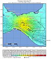
 2017 Intensity of the earthquake in Mexico (Chiapas).jpg 612 × 723; 110 KB
-
-
 2018 Oaxaca earthquake shake map.jpg 612 × 718; 103 KB
-
 2019-02-01 Frontera Hidalgo, Mexico M6.5 earthquake shakemap (USGS).jpg 879 × 1,072; 307 KB
-
 2019-02-01 Puerto Madero, Mexico M6.6 earthquake shakemap (USGS).jpg 612 × 718; 106 KB
-
 2019-11-20 Puerto Madero, Mexico M6.3 earthquake shakemap (USGS).jpg 812 × 1,024; 167 KB
-
 2020-05-22 San Jose del Cabo, Mexico M6.1 earthquake shakemap (USGS).jpg 835 × 998; 153 KB
-

-
-
 2021-09-08 Acapulco, Mexico M7 earthquake shakemap (USGS).jpg 787 × 996; 310 KB
-
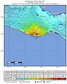
 2021-12-22 La Cruz de Loreto, Mexico M6 earthquake shakemap (USGS).jpg 790 × 998; 158 KB
-
 2021-12-23 La Cruz de Loreto, Mexico M6 earthquake shakemap (USGS).jpg 787 × 995; 161 KB
-
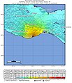
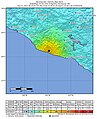
 2022-09-19 Aquila, Mexico M7.6 earthquake shakemap (USGS).jpg 788 × 1,000; 142 KB
-

-
 2022-09-22 Aguililla, Mexico M6.8 earthquake shakemap (USGS).jpg 811 × 999; 137 KB
-
 April 2010 Baja California aftershock intensity USGS.jpg 863 × 1,077; 559 KB
-
 April 2010 Baja California earthquake intensity USGS.jpg 612 × 718; 123 KB
-
 1995 Chiapas earthquake USGS shakemap.jpg 612 × 717; 119 KB
-
 Colima 1995 10 09 USGS loc.jpg 612 × 723; 156 KB
-
 Earthquake 5 km ENE of Raboso, Mexico, 2017.jpg 612 × 718; 117 KB
-
 2011 Guerrero earthquake USGS shakemap.jpg 541 × 662; 174 KB
-
 Intensidad del terremoto en Chiapas, México, 2017.png 648 × 874; 437 KB
-

-
 Intensity (1).jpg 612 × 718; 95 KB
-
 Intensity chiapas 2014.jpg 612 × 717; 97 KB
-
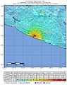
 M 7.7 - Oaxaca, Mexico (1978).jpg 787 × 984; 270 KB
-

-
 Mapa del temblor.jpg 612 × 717; 117 KB
-
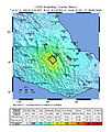
 Michoacan Earthquake 2012.jpg 612 × 718; 103 KB
-
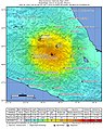
 Intensity Oaxaca 2012.jpg 612 × 720; 118 KB
-
 ShakeMap 7.5 Colima, Mexico.jpg 612 × 717; 102 KB
-
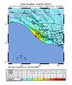
 ShakeMap 7.6 Michoacan, Mexico.jpg 2,466 × 3,116; 788 KB
-
 Shakemap USGS 7.5 Ch.jpg 833 × 1,078; 324 KB
-
 Sismo Guerrero-Oaxaca abril 2012.jpg 612 × 717; 101 KB
-
 USGS Guerrero shakemap.png 524 × 537; 456 KB
-
 USGS Shakemap - 1979 Imperial Valley earthquake.jpg 612 × 722; 185 KB
-
 USGS Shakemap 2011 Guerrero Mexico Earthquake.jpg 612 × 717; 126 KB


.jpg)
.jpg_(Datei).jpg)

.jpg)
.jpg)
.jpg)
.jpg)
.jpg)
.jpg)
.jpg)
.jpg)
.jpg)
.jpg)
.jpg)
.jpg)


.jpg)
.jpg)

.jpg)


