Category:Schoolmeesterswoning, Jeruzalemstraat 11 (Gouda)
Jump to navigation
Jump to search
| Object location | | View all coordinates using: OpenStreetMap |
|---|
cultural center in Gouda, the Netherlands  | |||||
| Upload media | |||||
| Instance of | |||||
|---|---|---|---|---|---|
| Location |
| ||||
| Inception |
| ||||
 | |||||
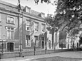
English: Former Schoolmasters house. Dated 1850 - 1875, Gouda NL
|
This is a category about a municipal monument in Gouda with number 73 |
Media in category "Schoolmeesterswoning, Jeruzalemstraat 11 (Gouda)"
The following 8 files are in this category, out of 8 total.
-
 Huis. Jeruzalemstraat 11, Gouda.jpg 3,240 × 4,320; 9.27 MB
-
 Jeruzalemstr. - Gouda - 20082361 - RCE.jpg 1,200 × 951; 328 KB
-
 Jeruzalemstr.11, inwendig - Gouda - 20082362 - RCE.jpg 890 × 1,200; 210 KB
-
 Jeruzalemstr.11, voorgevel - Gouda - 20082363 - RCE.jpg 1,200 × 891; 266 KB
-
 Voormalige schoolmeesterwoning, Jeruzalemstraat 11, Gouda (1) Interieur.jpg 3,240 × 4,320; 8.51 MB
-
 Voormalige schoolmeesterwoning, Jeruzalemstraat 11, Gouda (2) Interieur.jpg 4,320 × 3,240; 5.05 MB
-
 Voormalige schoolmeesterwoning, Jeruzalemstraat 11, Gouda (3) Graf.jpg 4,320 × 3,240; 5.32 MB
-
 Voormalige schoolmeesterwoning, Jeruzalemstraat 11, Gouda (4).jpg 4,320 × 3,240; 8.83 MB


_Interieur.jpg)
_Interieur.jpg)
_Graf.jpg)
.jpg)