Category:Schloss Dahme
Jump to navigation
Jump to search
| Object location | | View all coordinates using: OpenStreetMap |
|---|
castle in Landkreis Teltow-Fläming, Brandenburg, Germany  | |||||
| Upload media | |||||
| Instance of | |||||
|---|---|---|---|---|---|
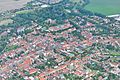
| Location | Dahme/Mark, Amt Dahme/Mark, Teltow-Fläming District, Brandenburg, Germany | ||||
| Heritage designation | |||||
 | |||||
This is the category of the Brandenburger Baudenkmal (cultural heritage monument) with the ID 09105126 (Wikidata)
|
Information about the castle: [1]
Media in category "Schloss Dahme"
The following 34 files are in this category, out of 34 total.
-
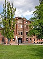
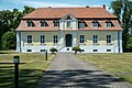
 20150508400MDR Dahme (Mark) Schloß.jpg 4,040 × 1,991; 5.69 MB
-
 20150508405DR Dahme (Mark) Schloß.jpg 1,797 × 2,455; 3.93 MB
-
 20150508410DR Dahme (Mark) Schloß.jpg 2,495 × 1,875; 4.17 MB
-
 20150508415DR Dahme (Mark) Schloß Wappen.jpg 3,000 × 1,832; 3.22 MB
-
 20150508420MDR Dahme (Mark) Schloß.jpg 3,708 × 1,890; 5.75 MB
-
 20150508425MDR Dahme (Mark) Schloß.jpg 3,494 × 1,914; 5.43 MB
-
 20150508430DR Dahme (Mark) Schloß INFO.jpg 2,589 × 2,988; 4.33 MB
-
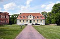 20150508440DR Dahme (Mark) Kavaliershaus.jpg 2,457 × 1,622; 3.34 MB
-
 20150508445DR Dahme (Mark) Kavaliershaus.jpg 2,416 × 1,648; 3.25 MB
-
 Dahme Schlossruine.jpg 960 × 920; 332 KB
-
 DahmeMark Kavaliershaus.jpg 5,472 × 3,648; 1.53 MB
-
 DahmeMark Kavaliershaus1.jpg 5,182 × 3,455; 1.62 MB
-
 DahmeMark Schloss.jpg 8,978 × 4,837; 1.38 MB
-
 Lausitz Luftsport- & Techniktage 2013-Rueckflug by-RaBoe 100.jpg 2,600 × 1,727; 936 KB
-
 Lausitz Luftsport- & Techniktage 2013-Rueckflug by-RaBoe 101.jpg 2,600 × 1,727; 902 KB
-
 Schloss Ruine Dahme Mark.jpg 4,928 × 3,264; 12.53 MB
-
 Schlossruine Dahme 01.jpg 4,503 × 3,377; 2.48 MB
-
 Schlossruine Dahme 02.jpg 4,608 × 3,456; 3.35 MB
-
 Schlossruine Dahme 03.jpg 4,608 × 3,456; 4.34 MB
-
 Schlossruine Dahme 04.jpg 4,608 × 3,456; 4.18 MB
-
 Schlossruine Dahme 05.jpg 4,608 × 3,456; 4.12 MB
-
 Schlossruine Dahme 06.jpg 4,503 × 3,377; 2.41 MB
-
 Schlossruine Dahme 07.jpg 4,608 × 3,456; 4.06 MB
-
 Schlossruine Dahme 08.jpg 4,608 × 3,456; 5.26 MB
-
 Schlossruine Dahme 09.jpg 4,608 × 3,456; 4.25 MB
-
 Schlossruine Dahme 10.jpg 4,608 × 3,456; 3.08 MB
-
 Schlossruine Dahme 11.jpg 4,503 × 3,377; 2.23 MB
-
 Schlossruine Dahme 12.jpg 4,608 × 3,456; 3.44 MB
-
 Schlossruine Dahme 13.jpg 4,608 × 3,456; 3.87 MB
-
 Schlossruine Dahme 14.jpg 4,608 × 3,456; 3.7 MB
-
 Schlossruine Dahme 15.jpg 4,608 × 3,456; 3.34 MB
-
 Schlossruine Dahme 16.jpg 4,608 × 3,456; 2.41 MB
-
 Schlossruine Dahme 17.jpg 4,608 × 3,456; 3.32 MB
-
 Schlossruine Dahme 18.jpg 4,608 × 3,456; 3.96 MB
_Schlo%C3%9F.jpg)
_Schlo%C3%9F.jpg)
_Schlo%C3%9F.jpg)
_Schlo%C3%9F_Wappen.jpg)
_Schlo%C3%9F.jpg)
_Schlo%C3%9F.jpg)
_Schlo%C3%9F_INFO.jpg)
_Kavaliershaus.jpg)
_Kavaliershaus.jpg)


