Category:Satellite pictures of glaciers of Greenland
Jump to navigation
Jump to search
Subcategories
This category has only the following subcategory.
Media in category "Satellite pictures of glaciers of Greenland"
The following 18 files are in this category, out of 18 total.
-
 Envisat image of Rinks Isbrae glacier, Greenland ESA220629.jpg 1,500 × 865; 1,012 KB
-
 Glaciers at the Dove Bay, Greenland (51968884731).png 12,000 × 8,098; 167.52 MB
-
 Glaciers breaking into Baffin Bay, Greenland (51998942417).png 15,000 × 9,966; 186.26 MB
-
 Glaciers Flow into a Greenland Valley.jpg 2,559 × 3,207; 981 KB
-
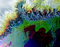
 Glaciers of Eastern Greenland (51746417024).png 10,000 × 6,712; 139.7 MB
-
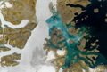
 Glaciers of Western Greenland (50096557146).png 16,480 × 11,000; 178.61 MB
-
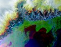
 Greenland Glaciers (51746106788).png 9,672 × 6,712; 128.66 MB
-
 Greenland Ilulissat.jpg 924 × 764; 493 KB
-
 Greenland tmo 2003186.jpg 540 × 405; 99 KB
-
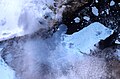 Ice Island Calves off Petermann Glacier - Flickr - NASA Goddard Photo and Video.jpg 2,618 × 1,733; 3.72 MB
-

-
 Kangerlussuaq Glacier, Greenland ESA23893037.jpeg 10,004 × 7,809; 14.85 MB
-
 Kangerlussuaq Glacier, Greenland ESA23893037.tiff 10,004 × 7,809; 223.53 MB
-
 Major Greenland Glacier Is Growing.jpeg 6,707 × 4,471; 7.08 MB
-
 Petermann Glacier - calving event July 16, 2012.jpg 5,000 × 5,000; 6.7 MB
-
 Petermann Glacier September 2008 (High Res) - Flickr - NASA Goddard Photo and Video.jpg 5,010 × 3,099; 5.05 MB
-

-
 Sermeq Kujalleq, Greenland Glacier (49657770236).png 13,575 × 8,767; 153.94 MB

.png)
.png)

.png)
.png)
.png)


_-_Flickr_-_NASA_Goddard_Photo_and_Video.jpg)
_-_Flickr_-_NASA_Goddard_Photo_and_Video.jpg)
.png)