Category:Sanborn maps of the Bronx published in 1908, V. A
Jump to navigation
Jump to search
Maps from: Insurance maps of the City of New York Borough of the Bronx. Volume A. (New York: Sanborn Map Company, 1908), comprising title page, two-page street index (with additions dated May 1916 and February 1917), volume key, key to house numbers, and 68 plates (maps). Plates 41–45 and Plate 48, in addition to the volume key and the first page of the street index, are missing from this category.
Source: The New York Public Library Digital Collections website, Vol. A
Media in category "Sanborn maps of the Bronx published in 1908, V. A"
The following 65 files are in this category, out of 65 total.
-

-
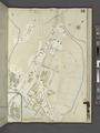
 Additional Index NYPL2021059.tiff 5,412 × 7,216, 2 pages; 111.79 MB
-
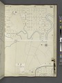
 Key Plan Showing the System of House Numbers NYPL2021062.tiff 5,412 × 7,216, 2 pages; 111.79 MB
-
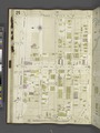
 Bronx, V. A, Plate No. 1 (Map bounded by Bronx Park East, Boston Rd., Bronx River, Bronx and Pelham Parkway.) NYPL2021064.tiff 5,412 × 7,216, 2 pages; 111.79 MB
-
 Bronx, V. A, Plate No. 2 (Map bounded by Barnes Ave., Lydig Ave., Bronx Park East, Pelham Parkway South.) NYPL2021065.tiff 5,412 × 7,216, 2 pages; 111.79 MB
-
 Bronx, V. A, Plate No. 3 (Map bounded by Bogart Ave., Neil Ave., Unionport Rd., Bronx Park East, Lydig Ave.) NYPL2021066.tiff 5,412 × 7,216, 2 pages; 111.79 MB
-
 Bronx, V. A, Plate No. 4 (Map bounded by Fowler Ave., Morris Park Ave., Unionport Rd., Neil Ave.) NYPL2021067.tiff 5,412 × 7,216, 2 pages; 111.79 MB
-

-
 Bronx, V. A, Plate No. 6 (Map bounded by Williamsbridge Rd., Sacket Ave., Bronxdale Ave., Morris Park Ave.) NYPL2021069.tiff 5,412 × 7,216, 2 pages; 111.79 MB
-
 Bronx, V. A, Plate No. 7 (Map bounded by Morris Park Ave., Barnes Ave., East Tremont Ave., Unionport Rd., Victor St.) NYPL2021070.tiff 5,412 × 7,216, 2 pages; 111.79 MB
-
 Bronx, V. A, Plate No. 8 (Map bounded by Morris Park Ave., Bronxdale Ave., East Tremont Ave., Barnes Ave.) NYPL2021071.tiff 5,412 × 7,216, 2 pages; 111.79 MB
-
 Bronx, V. A, Plate No. 9 (Map bounded by Morris Park Ave., Melville St., Walker Ave., East Tremont Ave.) NYPL2021072.tiff 5,412 × 7,216, 2 pages; 111.79 MB
-

-
 Bronx, V. A, Plate No. 11 (Map bounded by Unionport Rd., Morris Park Ave., Bronx Park.) NYPL2021074.tiff 5,412 × 7,216, 2 pages; 111.79 MB
-
 Bronx, V. A, Plate No. 12 (Map bounded by Bronx International Exposition, E. 177th St., East Tremont Ave.) NYPL2021075.tiff 5,412 × 7,216, 2 pages; 111.79 MB
-
 Bronx, V. A, Plate No. 13 (Map bounded by Watson's Lane, Manor Ave., Westchester Ave., Bronx River.) NYPL2021076.tiff 5,412 × 7,216, 2 pages; 111.79 MB
-
 Bronx, V. A, Plate No. 14 (Map bounded by Westchester Ave.) NYPL2021077.tiff 5,412 × 7,216, 2 pages; 111.79 MB
-
 Bronx, V. A, Plate No. 15 (Map bounded by East Tremont Ave., Beach Ave., E. 174th St., Rosedale Ave.) NYPL2021078.tiff 5,412 × 7,216, 2 pages; 111.79 MB
-
 Bronx, V. A, Plate No. 16 (Map bounded by East Tremont Ave., Gary St., Wood Ave., Beach Ave.) NYPL2021079.tiff 5,412 × 7,216, 2 pages; 111.79 MB
-
 Bronx, V. A, Plate No. 17 (Map bounded by East Tremont Ave., Unionport Rd., McGraw Ave., Gray St.) NYPL2021080.tiff 5,412 × 7,216, 2 pages; 111.79 MB
-
 Bronx, V. A, Plate No. 18 (Map bounded by Bronxdale Ave., Zerega Ave., Raymond St., Protectory Ave.) NYPL2021081.tiff 5,412 × 7,216, 2 pages; 111.79 MB
-
 Bronx, V. A, Plate No. 19 (Map bounded by Gray St., Westchester Ave., Commonwealth Ave., Wood Ave.) NYPL2021082.tiff 5,412 × 7,216, 2 pages; 111.79 MB
-
 Bronx, V. A, Plate No. 20 (Map bounded by Olmstead Ave., Ellis Ave., Virginia Ave., McGraw Ave.) NYPL2021083.tiff 5,412 × 7,216, 2 pages; 111.79 MB
-
 Bronx, V. A, Plate No. 21 (Map bounded by Olmstead Ave., Blackrock Ave., Virginia Ave., Ellis Ave.) NYPL2021084.tiff 5,412 × 7,216, 2 pages; 111.79 MB
-
 Bronx, V. A, Plate No. 22 (Map bounded by Olmstead Ave., Houghton Ave., White Plains Rd., Blackrock Ave.) NYPL2021085.tiff 5,412 × 7,216, 2 pages; 111.79 MB
-
 Bronx, V. A, Plate No. 23 (Map bounded by Havemeyer Ave., Ludlow Ave., Olmstead Ave., Powell Ave.) NYPL2021086.tiff 5,412 × 7,216, 2 pages; 111.79 MB
-
 Bronx, V. A, Plate No. 24 (Map bounded by Havemeyer Ave., Hermany Ave., Olmstead Ave., Ludlow Ave.) NYPL2021087.tiff 5,412 × 7,216, 2 pages; 111.79 MB
-
 Bronx, V. A, Plate No. 25 (Map bounded by Havemeyer Ave., Powell Ave., Olmstead Ave., Westchester Ave.) NYPL2021088.tiff 5,412 × 7,216, 2 pages; 111.79 MB
-

-
 Bronx, V. A, Plate No. 27 (Map bounded by Westchester Creek, Ludlow Ave., Havemeyer Ave., Haviland Ave.) NYPL2021090.tiff 5,412 × 7,216, 2 pages; 111.79 MB
-
 Bronx, V. A, Plate No. 28 (Map bounded by Westchester Creek, Turnbull Ave., Havemeyer Ave., Ludlow Ave.) NYPL2021091.tiff 5,412 × 7,216, 2 pages; 111.79 MB
-
 Bronx, V. A, Plate No. 29 (Map bounded by East Tremont Ave., Maud Pl., Seberry Creek, Balcom Ave.) NYPL2021092.tiff 5,412 × 7,216, 2 pages; 111.79 MB
-
 Bronx, V. A, Plate No. 30 (Map bounded by Balcom Ave., Chidsey St., E. 177th St., Westchester Creek.) NYPL2021093.tiff 5,412 × 7,216, 2 pages; 111.79 MB
-
 Bronx, V. A, Plate No. 31 (Map bounded by Protectory Ave., Raymond Ave., Parker St., Westchester Ave.) NYPL2021094.tiff 5,412 × 7,216, 2 pages; 111.79 MB
-
 Bronx, V. A, Plate No. 32 (Map bounded by Glebe Ave., St. Peter's St., Seabury Ave., Waterbury Ave., Glover St.) NYPL2021095.tiff 5,412 × 7,216, 2 pages; 111.79 MB
-

-
 Bronx, V. A, Plate No. 34 (Map bounded by Westchester Creek, Ericson Pl., East Tremont Ave., Blondell Ave.) NYPL2021097.tiff 5,412 × 7,216, 2 pages; 111.79 MB
-
 Bronx, V. A, Plate No. 35 (Map bounded by Poplar St., Overing St., Glebe Ave., Zerega Ave., Castle Hill Ave.) NYPL2021098.tiff 5,412 × 7,216, 2 pages; 111.79 MB
-
 Bronx, V. A, Plate No. 36 (Map bounded by Barlow St., Blondell Ave., Halperin Ave., Overing St.) NYPL2021099.tiff 5,412 × 7,216, 2 pages; 111.79 MB
-
 Bronx, V. A, Plate No. 37 (Map bounded by Bronx and Pelham Parkway, Elberon Ave., Morris Park Ave., Williamsbridge Rd.) NYPL2021100.tiff 5,412 × 7,216, 2 pages; 111.79 MB
-
 Bronx, V. A, Plate No. 38 (Map bounded by Saratoga Ave., Morris Park Ave., Westchester Creek, Williamsbridge Rd.) NYPL2021101.tiff 5,412 × 7,216, 2 pages; 111.79 MB
-
 Bronx, V. A, Plate No. 39 (Map bounded by Elberon Ave., Bronx and Pelham Parkway, Pilgrim Ave., Morris Park Ave.) NYPL2021102.tiff 5,412 × 7,216, 2 pages; 111.79 MB
-
 Bronx, V. A, Plate No. 40 (Map bounded by Bronx and Pelham Parkway, Eastern Blvd., Morris Park Ave., Pilgrim Ave.) NYPL2021103.tiff 5,412 × 7,216, 2 pages; 111.79 MB
-
 Bronx, V. A, Plate No. 46 (Map bounded by Latting St., Eastern Boulevard, East Tremont Ave., Mayflower Ave.) NYPL2021109.tiff 5,412 × 7,216, 2 pages; 111.79 MB
-
 Bronx, V. A, Plate No. 47 (Map bounded by St. Joseph's Ave., E. 177th St., Westchester Creek.) NYPL2021110.tiff 5,412 × 7,216, 2 pages; 111.79 MB
-
 Bronx, V. A, Plate No. 49 (Map bounded by Turnbull Ave., Westchester Creek, Castle Hill Ave.) NYPL2021112.tiff 5,412 × 7,216, 2 pages; 111.79 MB
-
 Bronx, V. A, Plate No. 50 (Map bounded by E. 177th St., Verris Ave., Westchester Creek.) NYPL2021113.tiff 5,412 × 7,216, 2 pages; 111.79 MB
-
 Bronx, V. A, Plate No. 51 (Map bounded by Pugsley's Creek, Underhill Ave., Patterson Ave., St. Lawrence Ave.) NYPL2021114.tiff 5,412 × 7,216, 2 pages; 111.79 MB
-
 Bronx, V. A, Plate No. 52 (Map bounded by Pugsley's Creek, Olmstead Ave., Sound View Ave.) NYPL2021115.tiff 5,412 × 7,216, 2 pages; 111.79 MB
-
 Bronx, V. A, Plate No. 53 (Map bounded by White Plains Rd., Watson Ave., Clauson's Point Rd., Westchester Ave.) NYPL2021116.tiff 5,412 × 7,216, 2 pages; 111.79 MB
-
 Bronx, V. A, Plate No. 54 (Map bounded by Underhill Ave., Pugsley's Creek Sound View Ave., Watson Ave.) NYPL2021117.tiff 5,412 × 7,216, 2 pages; 111.79 MB
-
 Bronx, V. A, Plate No. 55 (Map bounded by Westchester Ave., Bronx River.) NYPL2021118.tiff 5,412 × 7,216, 2 pages; 111.79 MB
-
 Bronx, V. A, Plate No. 56 (Map bounded by Westchester Ave., Old Clason's Point Rd., Story Ave., Craighill Ave.) NYPL2021119.tiff 5,412 × 7,216, 2 pages; 111.79 MB
-
 Bronx, V. A, Plate No. 57 (Map bounded by Bronx River.) NYPL2021120.tiff 5,412 × 7,216, 2 pages; 111.79 MB
-
 Bronx, V. A, Plate No. 58 (Map bounded by Pugsley's Creek, Westchester Creek, East River.) NYPL2021121.tiff 5,412 × 7,216, 2 pages; 111.79 MB
-
 Bronx, V. A, Plate No. 59 (Map bounded by East River, Westchester Creek.) NYPL2021122.tiff 5,412 × 7,216, 2 pages; 111.79 MB
-
 Bronx, V. A, Plate No. 60 (Map bounded by East Tremont Ave., East River.) NYPL2021123.tiff 5,412 × 7,216, 2 pages; 111.79 MB
-
 Bronx, V. A, Plate No. 61 (Map bounded by Fort Schuyler Rd., Hammond's Creek, East River, East Tremont Ave.) NYPL2021124.tiff 5,412 × 7,216, 2 pages; 111.79 MB
-
 Bronx, V. A, Plate No. 62 (Map bounded by East Tremont Ave., Weir Creek, Long Island Sound, Morgan Ave.) NYPL2021125.tiff 5,412 × 7,216, 2 pages; 111.79 MB
-
 Bronx, V. A, Plate No. 63 (Map bounded by E. 177th St., Philip Ave., Long Island Sound, Dewey Ave.) NYPL2021126.tiff 5,412 × 7,216, 2 pages; 111.79 MB
-

-
 Bronx, V. A, Plate No. 65 (Map bounded by Eastern Boulevard, North Road, Eastchester Bay, Layton Ave.) NYPL2021128.tiff 5,412 × 7,216, 2 pages; 111.79 MB
-
 Bronx, V. A, Plate No. 66 (Map bounded by Eastern Boulevard, Eastchester Bay, North Rd.) NYPL2021129.tiff 5,412 × 7,216, 2 pages; 111.79 MB
-
 Bronx, V. A, Plate No. 67 (Map bounded by Eastern Boulevard, Pelham Bay Park, Eastchester Bay.) NYPL2021130.tiff 5,412 × 7,216, 2 pages; 111.79 MB
-
 Bronx, V. A, Plate No. 68 (Map bounded by Fordham Rd., Eastchester Bay, Eastern Boulevard.) NYPL2021131.tiff 5,412 × 7,216, 2 pages; 111.79 MB