Category:San Andrés (Tenerife)
Jump to navigation
Jump to search
| Camera location | | View all coordinates using: OpenStreetMap |
|---|
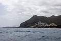
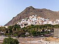
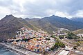
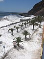
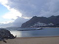
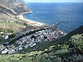
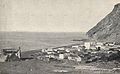
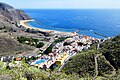
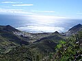
English: Pictures of San Andrés (Tenerife) a village belongs to the municipality Santa Cruz de Tenerife in the northeastern part of the island of Tenerife one of the islands of the Canary Islands in Spain. San Andrés (Tenerife) is near the beach Playa de Las Teresitas and the Mirador Las Teresitas. San Andrés (Tenerife) is also not far of the Anaga Massif and the mountain range Macizo de Anaga
Español: San Andrés (Santa Cruz de Tenerife), un pueblo de Santa Cruz de Tenerife, Islas Canarias en España
English: San Andrés (Santa Cruz de Tenerife), a village of Santa Cruz de Tenerife on the island Tenerife one of the Canary Islands in Spain
Deutsch: San Andrés (Teneriffa), ein Ort in der Gemeinde Santa Cruz de Tenerife auf der kanarischen Insel Teneriffa die größte der Kanarische Inseln in Spanien
village in Santa Cruz de Tenerife   | |||||
| Upload media | |||||
| Instance of | |||||
|---|---|---|---|---|---|
| Location | Santa Cruz de Tenerife, Santa Cruz de Tenerife Province, Canary Islands, Spain | ||||
| Elevation above sea level |
| ||||
 | |||||
Subcategories
This category has the following 11 subcategories, out of 11 total.
B
- Barranco de San Andrés (8 F)
H
I
P
- Playa de las Gaviotas (4 F)
S
- San Andrés Castle (21 F)
- San Andrés cemetery (17 F)
T
V
- Valle de las Huertas (3 F)
Media in category "San Andrés (Tenerife)"
The following 42 files are in this category, out of 42 total.
-
 38729 San Andrés, Santa Cruz de Tenerife, Spain - panoramio (1).jpg 2,048 × 1,153; 727 KB
-
 38729 San Andrés, Santa Cruz de Tenerife, Spain - panoramio (2).jpg 2,048 × 1,153; 538 KB
-
 38729 San Andrés, Santa Cruz de Tenerife, Spain - panoramio.jpg 2,048 × 1,153; 873 KB
-
 At Playa de Las Teresitas, Tenerife 2021 027.jpg 6,960 × 4,640; 23.5 MB
-
 At Playa de Las Teresitas, Tenerife 2021 028.jpg 6,960 × 4,640; 18.84 MB
-
 At Tenerife 2020 189.jpg 6,960 × 4,640; 22.27 MB
-
 Avenida Marítima de San Andrés (Tenerife).JPG 2,816 × 2,112; 1.17 MB
-
 Bandera del pueblo de San Andrés, Tenerife.jpg 373 × 259; 3 KB
-
 Barranco de Las Huertas.JPG 2,112 × 2,816; 1.27 MB
-
 Berg im Anaga Gebirge auf Teneriffa, Spanien (48225390257).jpg 2,383 × 3,581; 5.73 MB
-
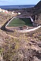 Campo de fútbol de San Andrés (Tenerife).jpg 1,728 × 2,592; 1.39 MB
-
 CDSanandres.jpg 947 × 1,585; 271 KB
-
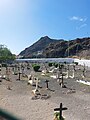 Cementerio de San Andres Teneriffe.jpg 3,468 × 4,624; 6.06 MB
-
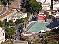 Centro cultural y cancha del grupo escolar de San Andrés..JPG 2,816 × 2,112; 1.31 MB
-
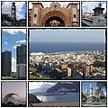 Collage Santa Cruz de Tenerife.jpg 404 × 404; 83 KB
-
 El Cercado (San Andrés, Tenerife).jpg 1,600 × 1,200; 734 KB
-
 El Cresal.JPG 2,048 × 1,536; 1.33 MB
-
 Escuela Estévez, San Andrés (Tenerife).jpg 1,200 × 1,600; 707 KB
-
 Kivimaalaus3.jpg 4,137 × 3,016; 2.94 MB
-
 Ladera de San Andrés (Tenerife).JPG 2,816 × 2,112; 1.24 MB
-
 Las Barranqueras y El Regente, San Andrés (Tenerife).JPG 2,816 × 2,112; 1.53 MB
-
 Localidad de San Andrés (Tenerife) wv banner.jpg 2,814 × 402; 370 KB
-
 Localidad de San Andrés (Tenerife).JPG 2,816 × 2,112; 1.27 MB
-
 Luftbild von San Andrés, Teneriffa (48225311891).jpg 5,464 × 3,640; 13 MB
-
 Mapa San Andres.jpg 962 × 551; 37 KB
-
 Oleaje.jpg 1,536 × 2,048; 436 KB
-
 Palmeral en la Viña Vieja (San Andrés, Tenerife).JPG 2,816 × 2,112; 1.48 MB
-
 Panorámica de San Andrés desde las Teresitas.JPG 1,280 × 960; 477 KB
-
 Pueblo de San Andrés.JPG 1,600 × 1,200; 423 KB
-
 San Andres Teneriffe.jpg 4,624 × 3,468; 2.29 MB
-
 San Andrés (Tenerife).JPG 640 × 480; 140 KB
-
 San Andrés (Teneriffa).JPG 4,288 × 2,848; 6.24 MB
-
 San Andrés - panoramio.jpg 5,166 × 3,428; 7.18 MB
-
 San Andrés 1905.jpg 2,440 × 1,500; 1.33 MB
-

-
 San Andrés Stadtviertel am Fuß des Anaga Gebirges auf Teneriffa, Spanien (48225293761).jpg 4,671 × 3,112; 10.87 MB
-
 San Andrés, Tenerife.jpg 4,720 × 3,147; 6.02 MB
-
 San Andrés, valley.jpg 4,032 × 3,024; 2.4 MB
-
 Steep coast near San Andrés Mountains on Tenerife, Spain (48225303621).jpg 5,464 × 3,640; 12.29 MB
-
 Steep side of San Andrés and Anaga Mountain on Tenerife, Spain (48225389167).jpg 3,847 × 2,560; 5.98 MB
-
 Tenerife coast near San Andrés.jpg 2,592 × 1,944; 2.14 MB
-
 Valle de San Andrés, Tenerife.JPG 640 × 480; 92 KB
.jpg)
.jpg)


.JPG)


.jpg)
.jpg)


.jpg)

.jpg)

.JPG)
.JPG)
.JPG)
.jpg)

.JPG)


.JPG)
.JPG)


.jpg)
.jpg)


.jpg)
.jpg)


_wv_banner.jpg)