Category:Saint-Paul City Fire Station
Jump to navigation
Jump to search
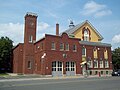
Français : Caserne de pompier de Côte-Saint-Paul, 5505 rue Anger, Montréal
| Object location | | View all coordinates using: OpenStreetMap |
|---|
Media in category "Saint-Paul City Fire Station"
The following 6 files are in this category, out of 6 total.
-
 Caserne de pompier de Cote-Saint-Paul.jpg 4,000 × 3,000; 3.36 MB
-
 WTMTL T14 IMG 5241.JPG 3,456 × 5,184; 4.87 MB
-
 WTMTL T29 DSC00114.JPG 4,592 × 3,056; 4.88 MB
-
 WTMTL T29 DSC00118.JPG 4,592 × 3,056; 4.84 MB
-
 WTMTL T29 DSC00119.JPG 4,592 × 3,056; 4.94 MB
-
 WTMTL T29 DSC00120.JPG 4,592 × 3,056; 4.91 MB


