Category:SVG maps of Svalbard
Jump to navigation
Jump to search
Subcategories
This category has the following 2 subcategories, out of 2 total.
Media in category "SVG maps of Svalbard"
The following 23 files are in this category, out of 23 total.
-
 Edgeøya LocationMap-lv.svg 1,480 × 1,950; 953 KB
-
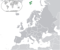 Europe-Svalbard.svg 2,045 × 1,720; 2.1 MB
-
 Festningen Geotope Protected Area map.svg 678 × 791; 822 KB
-
 Flag-map of Svalbard.svg 1,100 × 1,554; 162 KB
-
 Hopen map.svg 981 × 2,348; 85 KB
-
 Indre Wijdefjorden National Park map.svg 672 × 1,005; 10.71 MB
-
 Nordaustlandet LocationMap-lv.svg 1,480 × 1,950; 953 KB
-
 Norway Svalbard location map.svg 1,304 × 1,825; 495 KB
-
 Norway-Svalbard.svg 2,045 × 1,720; 7.35 MB
-
 Ossian Sars Nature Reserve map.svg 818 × 639; 1.9 MB
-
 Rescue of airship Italia by icebreaker Krasin.svg 152 × 152; 1.92 MB
-
 Shpitsbergen (PosMap).svg 2,197 × 2,835; 75 KB
-
 Spitsbergen LocationMap-lv.svg 1,480 × 1,950; 953 KB
-
 Spitsbergen.svg 329 × 355; 345 KB
-
 Svalbard geoflag.svg 212 × 214; 79 KB
-
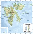
 Svalbard location map conic.svg 1,228 × 1,737; 7.53 MB
-
 Svalbard outline.svg 200 × 265; 21 KB
-
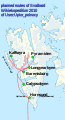 Svalbard Wikiexpedition 2010-project of routes-v1.svg 716 × 1,317; 377 KB
-
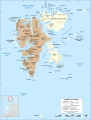
 Topographic map of Svalbard de.svg 2,497 × 2,537; 1.4 MB
-
 Topographic map of Svalbard lv.svg 2,497 × 2,537; 1.37 MB
-
 Topographic map of Svalbard ru.svg 2,497 × 2,537; 4.58 MB
-
 Topographic map of Svalbard uk.svg 2,497 × 2,537; 4.61 MB
-
 Topographic map of Svalbard.svg 2,497 × 2,537; 1.56 MB


.svg)


