Category:SVG locator maps of districts of Mizoram
Jump to navigation
Jump to search
States of India: Andhra Pradesh · Arunachal Pradesh · Assam · Bihar · Chhattisgarh · Goa · Gujarat · Haryana · Himachal Pradesh · Jharkhand · Karnataka · Kerala · Madhya Pradesh · Maharashtra · Manipur · Meghalaya · Mizoram · Nagaland · Odisha · Rajasthan · Sikkim · Tamil Nadu · Telangana · Tripura · Uttar Pradesh · Uttarakhand · West Bengal
Union territories: Jammu and Kashmir · Ladakh ·
Former states of India:
Former union territories:
Union territories: Jammu and Kashmir · Ladakh ·
Former states of India:
Former union territories:
Media in category "SVG locator maps of districts of Mizoram"
The following 11 files are in this category, out of 11 total.
-
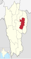
 Aizawl in Mizoram (India).svg 782 × 1,481; 909 KB
-
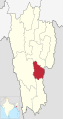
 Champhai in Mizoram (India).svg 782 × 1,481; 909 KB
-
 Hnahthial in Mizoram (India).svg 782 × 1,481; 909 KB
-
 Khawzawl in Mizoram (India).svg 782 × 1,481; 909 KB
-
 Kolasib in Mizoram (India).svg 782 × 1,481; 909 KB
-
 Lawngtai in Mizoram (India).svg 782 × 1,481; 909 KB
-
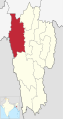
 Lunglei in Mizoram (India).svg 782 × 1,481; 909 KB
-
 Mamit in Mizoram (India).svg 782 × 1,481; 909 KB
-
 Saiha in Mizoram (India).svg 782 × 1,481; 909 KB
-
 Saitual in Mizoram (India).svg 782 × 1,481; 909 KB
-
 Serchhip in Mizoram (India).svg 782 × 1,481; 909 KB
.svg)
.svg)
.svg)
.svg)
.svg)
.svg)
.svg)
.svg)
.svg)
.svg)
.svg)