Category:SVG locator maps of districts of Jammu and Kashmir (location map scheme)
Jump to navigation
Jump to search
Media in category "SVG locator maps of districts of Jammu and Kashmir (location map scheme)"
The following 23 files are in this category, out of 23 total.
-
 Anantnag district in Jammu and Kashmir.svg 757 × 741; 473 KB
-
 Bandipora district in Jammu and Kashmir.svg 757 × 741; 473 KB
-
 Baramulla district in Jammu and Kashmir.svg 757 × 741; 473 KB
-
 Jammu and Kashmir Anantnag district.svg 836 × 641; 166 KB
-
 Jammu and Kashmir Bandipora district.svg 836 × 641; 166 KB
-
 Jammu and Kashmir Baramulla district.svg 836 × 641; 164 KB
-
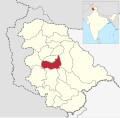
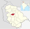
 Jammu and Kashmir Budgam district.svg 757 × 741; 473 KB
-
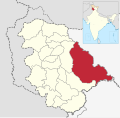
 Jammu and Kashmir Doda district.svg 757 × 741; 473 KB
-
 Jammu and Kashmir Ganderbal district.svg 757 × 741; 473 KB
-
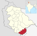
 Jammu and Kashmir Jammu district.svg 757 × 741; 473 KB
-
 Jammu and Kashmir Kathua district.svg 757 × 741; 473 KB
-
 Jammu and Kashmir Kishtwar district.svg 757 × 741; 473 KB
-
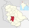
 Jammu and Kashmir Kulgam district.svg 757 × 741; 473 KB
-
 Jammu and Kashmir Kupwara district.svg 757 × 741; 473 KB
-
 Jammu and Kashmir Poonch district.svg 757 × 741; 473 KB
-
 Jammu and Kashmir Rajouri district.svg 757 × 741; 473 KB
-
 Jammu and Kashmir Ramban district.svg 757 × 741; 473 KB
-
 Jammu and Kashmir Reasi district.svg 757 × 741; 473 KB
-
 Jammu and Kashmir Samba district.svg 757 × 741; 473 KB
-
 Jammu and Kashmir Shopian district.svg 757 × 741; 473 KB
-
 Jammu and Kashmir Srinagar district.svg 757 × 741; 473 KB
-
 Jammu and Kashmir Udhampur district.svg 757 × 741; 473 KB
-
 Pulwama district in Jammu and Kashmir.svg 757 × 741; 473 KB


