Category:SVG locator maps of counties in Sweden (location map scheme)
Jump to navigation
Jump to search

|
SVG maps in this category are part of a locator map series applying the (de) widespread location map scheme. Please see root category to browse for more. |
.svg)
.svg)
.svg)
.svg)
.svg)
.svg)
.svg)
Locator maps design recommendations ▼ | |
|---|---|
Principles
Design Guidelines are based on ▸location map design of the German map shop (in German). It's preferable to derive new locator maps from existing location maps. Please keep both size and ratio in this case. Thus the new locator maps may still be applied as location map (▸Guide). Marker color is supposed to be darkred. Waterbodies may be transparent, to show other objects better. Please be aware that this guide is only a recommendation. It’s not an inevitable law!
Highlight small areas
“Remote” areas and mini maps
Mini maps show where the depicted area actually is situated. Check out ▸Vorlage:Positionskarte+ (in German) and ▸Modèle:Carte en coin (in French) of how to insert a mini map in virtually every map.
Disputed areas
Greyed special objects
Backgrounds
|

-en.svg)

.svg)
.svg)
.svg)

_(US48).svg)
_(small_islands_magnified)_(-mini_map_-rivers).svg)
.svg)
_(extra_close)_(US48).svg)
.svg)
_(zoom).svg)

.svg)


_(UNMIK).svg)
.svg)
_(disputed_hatched).svg)
_(claimed_and_disputed_hatched).svg)
.svg)
.svg)
_(%2Ball_claims_hatched).svg)

.svg)
_(shade).svg)
_(shade)_(special_marker).svg)
_(-mini_map).svg)
_(-mini_map).svg)
_(-mini_map).svg)


.svg)

.svg)
Media in category "SVG locator maps of counties in Sweden (location map scheme)"
The following 21 files are in this category, out of 21 total.
-
 Blekinge län in Sweden.svg 954 × 1,837; 2.21 MB
-
 Dalarnas län in Sweden.svg 954 × 1,837; 2.21 MB
-
 Gotlands län in Sweden.svg 954 × 1,837; 2.21 MB
-
 Gävleborgs län in Sweden.svg 954 × 1,837; 2.21 MB
-
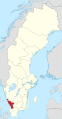 Hallands län in Sweden.svg 954 × 1,837; 2.21 MB
-
 Jämtlands län in Sweden.svg 954 × 1,837; 2.21 MB
-
 Jönköpings län in Sweden.svg 954 × 1,837; 2.21 MB
-
 Kalmar län in Sweden.svg 954 × 1,837; 2.21 MB
-
 Kronobergs län in Sweden.svg 954 × 1,837; 2.21 MB
-
 Norrbottens län in Sweden.svg 954 × 1,837; 2.21 MB
-
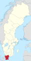 Skåne län in Sweden.svg 954 × 1,837; 2.21 MB
-
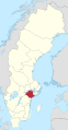
 Stockholms län in Sweden.svg 954 × 1,837; 2.21 MB
-
 Södermanlands län in Sweden.svg 954 × 1,837; 2.21 MB
-
 Uppsala län in Sweden.svg 954 × 1,837; 2.21 MB
-
 Värmlands län in Sweden.svg 954 × 1,837; 2.21 MB
-
 Västerbottens län in Sweden.svg 954 × 1,837; 2.21 MB
-
 Västernorrlands län in Sweden.svg 954 × 1,837; 2.21 MB
-
 Västmanlands län in Sweden.svg 954 × 1,837; 2.21 MB
-
 Västra Götalands län in Sweden.svg 954 × 1,837; 2.21 MB
-
 Örebro län in Sweden.svg 954 × 1,837; 2.21 MB
-
 Östergötlands län in Sweden.svg 954 × 1,837; 2.21 MB


