Category:SVG locator maps of British Overseas Territories in the United Kingdom (location map scheme)
Jump to navigation
Jump to search

|
SVG maps in this category are part of a locator map series applying the (de) widespread location map scheme. Please see root category to browse for more. |
.svg)
.svg)
.svg)
.svg)
.svg)
.svg)
.svg)
Locator maps design recommendations ▼ | |
|---|---|
Principles
Design Guidelines are based on ▸location map design of the German map shop (in German). It's preferable to derive new locator maps from existing location maps. Please keep both size and ratio in this case. Thus the new locator maps may still be applied as location map (▸Guide). Marker color is supposed to be darkred. Waterbodies may be transparent, to show other objects better. Please be aware that this guide is only a recommendation. It’s not an inevitable law!
Highlight small areas
“Remote” areas and mini maps
Mini maps show where the depicted area actually is situated. Check out ▸Vorlage:Positionskarte+ (in German) and ▸Modèle:Carte en coin (in French) of how to insert a mini map in virtually every map.
Disputed areas
Greyed special objects
Backgrounds
|

-en.svg)

.svg)
.svg)
.svg)

_(US48).svg)
_(small_islands_magnified)_(-mini_map_-rivers).svg)
.svg)
_(extra_close)_(US48).svg)
.svg)
_(zoom).svg)

.svg)


_(UNMIK).svg)
.svg)
_(disputed_hatched).svg)
_(claimed_and_disputed_hatched).svg)
.svg)
.svg)
_(%2Ball_claims_hatched).svg)

.svg)
_(shade).svg)
_(shade)_(special_marker).svg)
_(-mini_map).svg)
_(-mini_map).svg)
_(-mini_map).svg)


.svg)

.svg)
Media in category "SVG locator maps of British Overseas Territories in the United Kingdom (location map scheme)"
The following 17 files are in this category, out of 17 total.
-
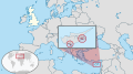 Akrotiri and Dhekelia in United Kingdom.svg 578 × 325; 6.97 MB
-
 Anguilla in United Kingdom.svg 1,021 × 575; 7.22 MB
-
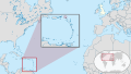
 Bermuda in United Kingdom.svg 689 × 387; 6.9 MB
-
 British Antarctic Territory in United Kingdom.svg 1,279 × 1,645; 7.03 MB
-
 British Indian Ocean Territory in United Kingdom.svg 1,466 × 810; 7.1 MB
-
 British Virgin Islands in United Kingdom.svg 1,021 × 575; 7.22 MB
-
 Cayman Islands in United Kingdom.svg 1,021 × 575; 6.95 MB
-
 Falkland Islands in United Kingdom.svg 1,559 × 1,541; 7.13 MB
-
 Gibraltar in United Kingdom.svg 537 × 302; 6.87 MB
-
 Montserrat in United Kingdom.svg 1,021 × 575; 7.21 MB
-
 Pitcairn Islands in United Kingdom.svg 5,519 × 3,104; 9 MB
-
 Saint Helena, Ascension and Tristan da Cunha in United Kingdom.svg 1,559 × 1,147; 6.97 MB
-
 South Georgia and the South Sandwich Islands in United Kingdom.svg 1,559 × 1,541; 7.13 MB
-
 Turks and Caicos Islands in United Kingdom (special marker).svg 1,021 × 575; 7.01 MB
-
 Turks and Caicos Islands in United Kingdom.svg 1,021 × 575; 7.01 MB
-
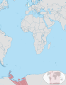
 United Kingdom in its region (Caribbean special).svg 351 × 197; 6.88 MB
-
 United Kingdom in its region (North America special).svg 415 × 233; 6.89 MB


.svg)

.svg)
.svg)