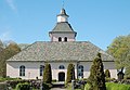
Category:Rudskoga kyrka
Jump to navigation
Jump to search
| Object location | | View all coordinates using: OpenStreetMap |
|---|
church building in Kristinehamn Municipality, Sweden  | |||||
| Upload media | |||||
| Instance of | |||||
|---|---|---|---|---|---|
| Location | Kristinehamn Municipality, Värmland County, Sweden | ||||
| Diocese | |||||
| Has use |
| ||||
| Occupant | |||||
| Heritage designation |
| ||||
| Inception |
| ||||
 | |||||
Svenska: Rudskoga kyrka tillhör Rudskoga församling, Kristinehamns pastorat, Östra Värmlands kontrakt, Lunds stift / Diocese of Lund.
|
This is a category about an ecclesiastical monument in Sweden, number 21300000004244 in the RAÄ buildings database.
|
|
This is a category about a protected building in Sweden, number 21400000440316 in the RAÄ buildings database.
|
Media in category "Rudskoga kyrka"
The following 33 files are in this category, out of 33 total.
-
 Rudskoga kyrka - KMB - 16000200147512.jpg 917 × 600; 83 KB
-
 Rudskoga kyrka - KMB - 16000200147513.jpg 898 × 600; 86 KB
-
 Rudskoga kyrka - KMB - 16000200147519.jpg 920 × 600; 47 KB
-
 Rudskoga kyrka - KMB - 16000200147523.jpg 778 × 600; 118 KB
-
 Rudskoga kyrka - KMB - 16000200147525.jpg 850 × 600; 74 KB
-
 Rudskoga kyrka - KMB - 16000200147527.jpg 442 × 600; 35 KB
-
 Rudskoga kyrka - KMB - 16000200147528.jpg 836 × 600; 78 KB
-
 Rudskoga kyrka - KMB - 16000200147529.jpg 747 × 600; 68 KB
-
 Rudskoga kyrka - KMB - 16000200147531.jpg 784 × 600; 75 KB
-
 Rudskoga kyrka - KMB - 16000200147534.jpg 863 × 600; 114 KB
-
 Rudskoga kyrka - KMB - 16000200147536.jpg 292 × 600; 44 KB
-
 Rudskoga kyrka - KMB - 16000200147540.jpg 839 × 600; 58 KB
-
 Rudskoga kyrka - KMB - 16000200147542.jpg 459 × 600; 63 KB
-
 Rudskoga kyrka - KMB - 16000200147543.jpg 872 × 600; 66 KB
-
 Rudskoga kyrka - KMB - 16000200147545.jpg 465 × 600; 70 KB
-
 Rudskoga kyrka - KMB - 16000200147548.jpg 775 × 600; 103 KB
-
 Rudskoga kyrka - KMB - 16000200147550.jpg 418 × 600; 36 KB
-
 Rudskoga kyrka - KMB - 16000200147551.jpg 442 × 600; 44 KB
-
 Rudskoga kyrka - KMB - 16000200147552.jpg 440 × 600; 52 KB
-
 Rudskoga kyrka - KMB - 16000200147553.jpg 441 × 600; 23 KB
-
 Rudskoga kyrka - KMB - 16000200147554.jpg 441 × 600; 31 KB
-
 Rudskoga kyrka - KMB - 16000200147555.jpg 441 × 600; 44 KB
-
 Rudskoga kyrka - KMB - 16000200147556.jpg 443 × 600; 27 KB
-
 Rudskoga kyrka - KMB - 16000200147557.jpg 405 × 600; 21 KB
-
 Rudskoga kyrka 11.JPG 2,048 × 1,422; 2.14 MB
-
 Rudskoga kyrka 12.JPG 1,993 × 1,536; 3.1 MB
-
 Rudskoga kyrka old1.jpg 791 × 600; 64 KB
-
 Rudskoga Kyrkas altare 2019.jpg 4,928 × 3,264; 4.3 MB
-
 Rudskoga Kyrkas dopfunt 2019.jpg 4,928 × 3,264; 3.79 MB
-
 Rudskoga Kyrkas kyrkorgel 2019.jpg 4,928 × 3,264; 4.56 MB
-
 Rudskoga Kyrkas kyrksal 2019.jpg 4,928 × 3,264; 4.29 MB
-
 Rudskoga Kyrkas predikstol 2019.jpg 3,264 × 4,928; 4.45 MB
-
 Rudskoga-Elin-Altarskåp-1400-talets-sista-fjärdedel.jpg 366 × 493; 45 KB


Categories:
- 1770s churches in Värmland County
- Built in Kristinehamn Municipality in 1777
- Churches in the Diocese of Karlstad
- Churches in Kristinehamn Municipality
- Churches in Värmland
- Churches in Sweden built in 1777
- Neoclassical churches in Värmland County
- Listed churches in Kristinehamn Municipality
- Stone churches in Sweden
- White churches in Sweden
- Rudskoga
- Aisleless churches in Sweden