Category:Ruder Club Leer
Jump to navigation
Jump to search
| Object location | | View all coordinates using: OpenStreetMap |
|---|
Media in category "Ruder Club Leer"
The following 3 files are in this category, out of 3 total.
-
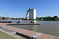 Leer - Hafen + Agravis + Bernic (Hafenufer Bürgermeister-Dieckmann-Straße) 10 ies.jpg 5,616 × 3,745; 16.94 MB
-
 Leer - Hafenufer Bürgermeister-Dieckmann-Straße + Hafen 05 ies.jpg 5,616 × 3,744; 17.8 MB
-
 Leer - Hafenufer Bürgermeister-Dieckmann-Straße + Hafen 10 ies.jpg 5,616 × 3,744; 19.51 MB
_10_ies.jpg)

