Category:Rottumeroog
Jump to navigation
Jump to search
Frisian Islands: Ameland · Amrum · Baltrum · Borkum · Engelsmanplaat · Föhr · Griend · Hamburger Hallig · Heligoland · Hallig Hooge · Japsand · Juist · Jungnamensand · Kachelotplate · Karkhof · Langeneß · Langeoog · Lütje Hörn · Mellum · Memmert · Minsener Oog · Noorderhaaks · Norderney · Norderoog · Norderoogsand · Nordstrand · Pellworm · Richel · Rif · Rottumeroog · Rottumerplaat · Schiermonnikoog · Simonszand · Spiekeroog · Süderoogsand · Sylt · Terschelling · Texel · Trischen · Vlieland · Wangerooge · Zuiderduintjes ·
island in the Netherlands  | |||||
| Upload media | |||||
| Spoken text audio | |||||
|---|---|---|---|---|---|
| Instance of | |||||
| Part of |
| ||||
| Named after | |||||
| Location |
| ||||
| Located in or next to body of water | |||||
| Width |
| ||||
| Length |
| ||||
| Population |
| ||||
| Area |
| ||||
 | |||||
Media in category "Rottumeroog"
The following 16 files are in this category, out of 16 total.
-
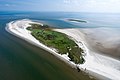
 Aerial photo of Rottumeroog 2.jpg 3,833 × 2,555; 1.62 MB
-
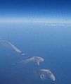
 Aerial photo of Rottumeroog.jpg 3,888 × 2,592; 1.67 MB
-
 Am Stande von Borkum 1867 Originalzeichnung von C. Bertling 0817 10013 0001.jpg 5,325 × 3,743; 5.25 MB
-
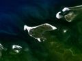 Borkum 6.72782E 53.59398N.jpg 1,280 × 958; 87 KB
-
 Ecomare - kwelder Rottum (ed-rottum-24-ck).jpg 2,592 × 1,944; 2.23 MB
-
 Ecomare - kwelderexcusie Rottumeroog (ed-rottum-28-ck).jpg 2,592 × 1,944; 1.93 MB
-
 Emder Kaap.jpg 3,543 × 4,724; 4.86 MB
-
 Landscape of Rottumeroog 1.jpg 3,072 × 2,048; 2.27 MB
-
Luchtopnamen Rottum-4714750.webm 4 min 0 s, 1,024 × 576; 32.64 MB
-
Nl-Rottumeroog-article.ogg 6 min 48 s; 3.92 MB
-
Nl-Rottumeroog.ogg 1.4 s; 17 KB
-
 Rottumeroog en Zuiderduintjes.jpg 219 × 221; 40 KB
-
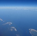
 Rottumeroog Rottumerplaat 6.53663E 53.54001N.jpg 1,280 × 958; 444 KB
-
 Rottumeroogpanorama.png 3,638 × 454; 1.36 MB
-
 Waddeneilanden 1.jpg 2,794 × 3,311; 3.89 MB
-
 Waddeneilanden 2.jpg 3,520 × 3,492; 5.02 MB


.jpg)
.jpg)


